
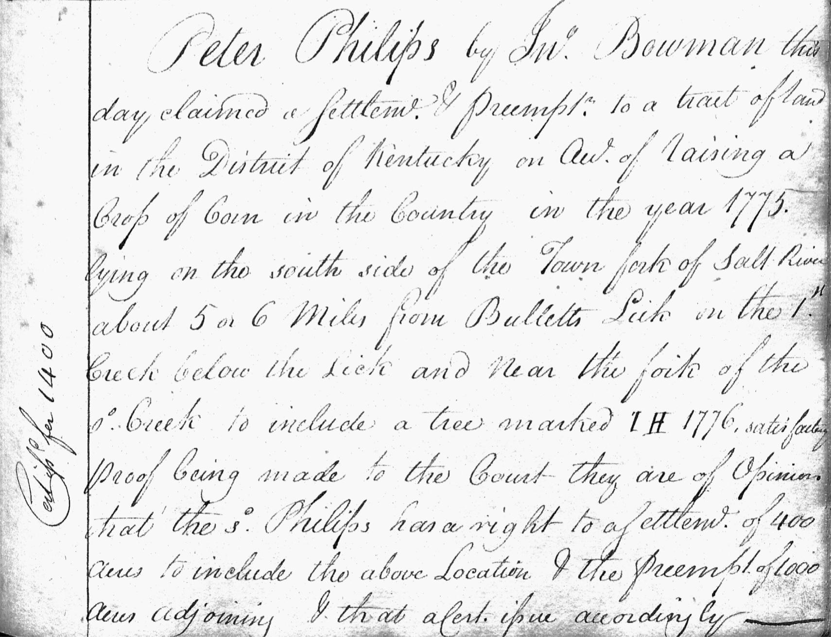
On 15 Feb 1780 at Harrodsburg, John Bowman appeared before the land commissioners carrying Peter Phillips' claim for settlement and preemption land as shown and transcribed below from page 347 of the Kentucky Doomsday Book.
"Peter Philips by Jno Bowman this day claimed a settlement & preemption to a tract of land in the District of Kentucky on account of raising a crop of corn in the Country in the year 1775, lying on the south side of the Town fork of Salt River about 5 or 6 miles from Bullitts Lick on the 1st creek below the lick and near the fork of the said creek to include a tree marked I H 1776, satisfactory proof being made to the court, they are of opinion that the said Philips has a right to a settlement of 400 acres to include the above location & the preemption of 1000 acres adjoining & that a certificate issue accordingly."
It was not uncommon for one individual to bring another person's claim before the commission, and the commissioners were satisfied with the claim and awarded the certificate.
On 28 Jun 1784, Benjamin Patton surveyed Phillips' settlement and preemption tracts, as shown below.
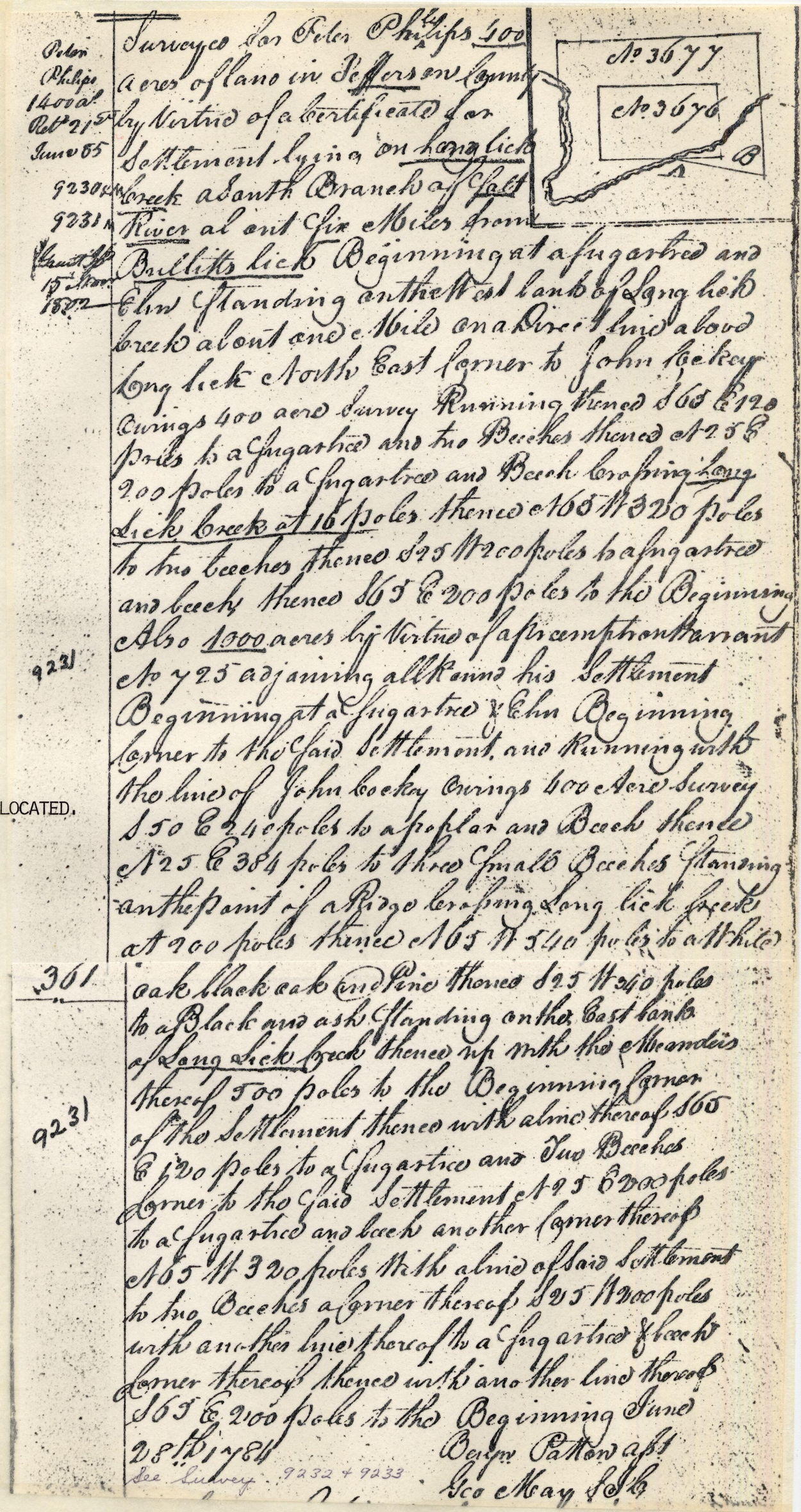
We have transcribed this document below. The various corner points are numbered with reference to the drawing that follows.
"Surveyed for Peter Phillips 400 acres of land in Jefferson County by virtue of a certificate for settlement lying on Long Lick Creek, a south branch of Salt River about five miles from Bullitt's Lick. Beginning at [1] a sugartree and elm standing on the west bank of Long Lick Creek about one mile on a direct line above Long Lick North East corner to John Cockey Owings 400 acre survey, running thence S 65 E 120 poles to [2] a sugartree and two beeches, thence N 25 E 200 poles to [3] a sugar tree and beech crossing Long Lick Creek at 16 poles, thence N 65 W 320 poles to [4] two beeches, thence S 25 W 200 poles to [5] a sugartree and beech, thence S 65 E 200 poles to [1] the Beginning.
Also 1000 acres by virtue of a presumption warrant No 725 adjoining ... his settlement. Beginning at [1] a sugartree & elm beginning corner to the said settlement and running with the line of John Cocky Owings 400 acre survey S 50 E 240 poles to [6] a poplar and beech, thence N 25 E 384 poles to [7] three small beeches standing on the point of a ridge crossing Long Lick Creek at 200 poles, thence N 65 W 540 poles to [8] a white oak, black oak and pine, thence S 25 W 340 poles to [9] a black and ash standing on the east bank of Long Lick Creek, thence up with the meanders thereof 500 poles to [1] the beginning corner of the settlement, thence with a line thereof S 65 E 120 poles to [2] a sugartree and two beeches corner to the said settlement, N 25 E 200 poles to [3] a sugartree and beech another corner thereof, N 65 W 320 poles with a line of said settlement to [4] two beeches a... thereof, S 25 W 200 poles with another line thereof to [5] a sugartree and beech corner thereof, thence with another line thereof S 65 E 200 poles to [1] the Beginning. June 28th 1784.
Benjamin Patton

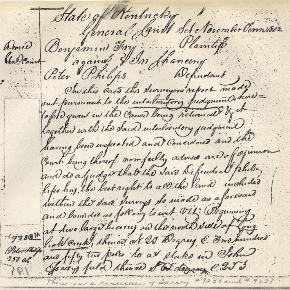
Before a deed could be obtained for these two tracts, Benjamin Frye filed a caveat, apparently claiming that part of these tracts interfered with his claims. We do not have the caveat itself, or the ensuing arguments, but apparently the two sides came to an agreement, for the General Court of the state of Kentucky in November 1802 made the following order, transcribed and shown below. As you will see, the boundary lines of the two Phillips' tracts were adjusted and the size of his tracts reduced. We have added letter markers to the description that refer to the map above.
State of Kentucky General Court Sct., November Term 1802
Benjamin Fry, plaintiff, against Peter Philips, defendant.
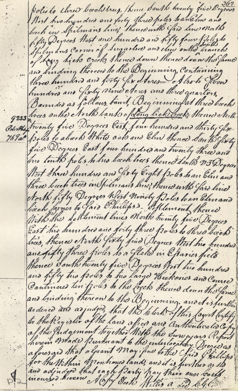
In this case the surveyor's report made out pursuant to the interlocutory judgment heretofore given in the cause being returned and it together in the said interlocutory judgment having been inspected and considered and the court being thereof now fully advised are of opinion and do adjudge that the said defendant Philips has the best right to all the land included within the said surveys so made as aforesaid and bounded as following to wit, viz: Beginning at [A] two large hickory on the north side of Long Lick Creek, thence N 25 degrees E two hundred and fifty two poles to [B] a stake in John Essary's field, thence S 65 degrees E 253 poles to [C] three beech trees, thence South twenty five degrees West two hundred and forty three poles to [D] an elm and beech in Spelman's line, thence with said line North fifty degrees West one hundred and fifty four poles to [E] Spelman's corner of sugartree and elm on the south branch of Long Lick Creek, thence down the same and binding thereon to [A] the beginning, containing three hundred and forty five acres. Also to seven hundred and sixty nine acres and three quarters, bounded as follows to wit, Beginning at [F] three beech trees on the North bank of Long Lick Creek, thence North twenty five degrees East four hundred and thirty six poles to [G] a beech, white oak and elm, thence South sixty five degrees East four hundred and twenty three and two tenth poles to [H] two beech trees, thence South 25 degrees West three hundred and sixty eight poles to [J] an elm and three beech trees in Spelman's line, thence with said line North fifty degrees West ninety poles to [D] an elm and beech corner to said Phillips' settlement, thence with the settlement lines North twenty five degrees East two hundred and forty three poles to [C] three beech trees, thence North sixty five degrees West two hundred and fifty three poles to [B] a stake in Essary's field, thence South twenty five degrees West two hundred and fifty two poles to [A] two large hickories and course continued ten poles to the creek, thence down the same and binding thereon to [F] the beginning. And it is further ordered and adjudged that the clerk of this court certify to the register of the land office an authenticated copy of the judgment together with the surveyor's report aforesaid that a grant may issue to the said Phillips for the within mentioned land, and it is further ordered and adjudged that each party pay their own costs. A copy teste Willis A. Lee CGC
By this time Matthew Thompson had obtained the original surveys and had assigned it to Matthew Patton Sr. A transcription of the deed that passed the land into Patton's hands is shown below.
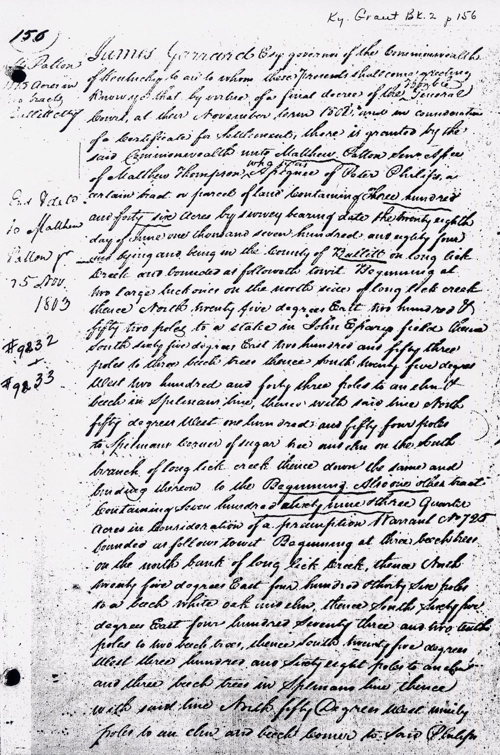
Kentucky Grant Book 2, page 156
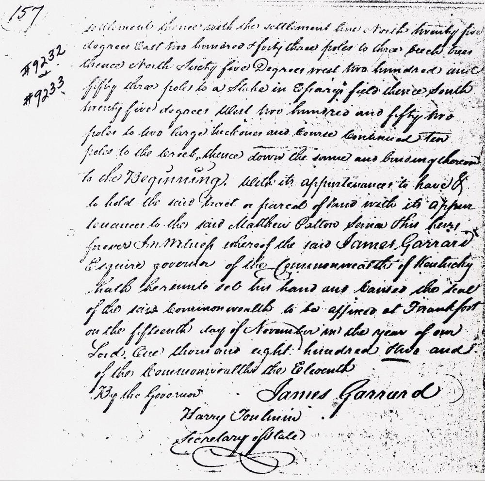
James Garrard Esquire, Governor of the Commonwealth of Kentucky to all to whom these presents shall come, greeting. Know ye that by virtue of a final decree of the ... General Court at their November term 1802, and in consideration of a certificate of settlement, there is granted by the said Commonwealth unto Matthew Patton Senior, assignee of Matthew Thompson who was assignee of Peter Philips, a certain tract or parcel of land containing three hundred and forty six acres by survey bearing date the twenty eighth day of June one thousand seven hundred and eighty four, and lying and being in the county of Bullitt on Long Lick Creek and bounded as followeth towit. Beginning at two large hickories on the north side of Long Lick Creek thence north twenty five degrees east two hundred and fifty two poles to a stake in John Essarys field, thence south sixty five degrees east two hundred and fifty three poles to three beech trees, thence south twenty five degrees west two hundred and forty three poles to an elm and beech in Spilman's line, thence with said line north fifty degrees west one hundred and fifty four poles to Spilman's corner of sugar tree and elm on the south branch of Long Lick Creek, thence down the same and binding thereon to the Beginning. Also one other tract containing seven hundred sixty nine and three quarters acres in consideration of a presumption warrant No. 725, bounded as followeth towit. Beginning at three beech trees on the north bank of Long Lick Creek, thence north twenty five degrees east four hundred thirty six poles to a beech, white oak and elm, thence south sixty five degrees east four hundred seventy three and two tenths poles to two beech trees, thence south twenty five degrees west three hundred and sixty eight poles to an elm and three beech trees in Spilman's line, thence with said line north fifty degrees west ninety poles to an elm and beech corner to said Philips' settlement, thence with the settlement line north twenty five degrees east two hundred and forty three poles to three beech trees, thence north sixty five degrees west two hundred and fifty three poles to a stake in Essary's field, thence south twenty five degrees west two hundred and fifty two poles to two large hickories and course continued ten poles to the creek, thence down the same and binding thereon to the Beginning with its appurtenances to have and to hold the said tract or parcel of land with its appurtenances to the said Matthew Patton Senior and his heirs forever. In witness whereof the said James Garrard Esquire, Governor of the Commonwealth of Kentucky hath hereunto set his hand and caused the seal of the said Commonwealth to be affixed at Frankfort on the fifteenth day of November in the year of our Lord, one thousand eight hundred and two and of the Commonwealth the eleventh.
By the Governor, James Garrard
A discussion of the relationship of these survey with adjacent ones may be found on another page.
If you, the reader, have an interest in any particular part of our county history, and wish to contribute to this effort, use the form on our Contact Us page to send us your comments about this, or any Bullitt County History page. We welcome your comments and suggestions. If you feel that we have misspoken at any point, please feel free to point this out to us.
The Bullitt County History Museum, a service of the Bullitt County Genealogical Society, is located in the county courthouse at 300 South Buckman Street (Highway 61) in Shepherdsville, Kentucky. The museum, along with its research room, is open 10 a.m. to 4 p.m. Monday through Friday. Saturday appointments are available by calling 502-921-0161 during our regular weekday hours. Admission is free. The museum, as part of the Bullitt County Genealogical Society, is a 501(c)3 tax exempt organization and is classified as a 509(a)2 public charity. Contributions and bequests are deductible under section 2055, 2106, or 2522 of the Internal Revenue Code. Page last modified: 12 Jan 2024 . Page URL: bullittcountyhistory.org/bchistory/peterphilipssurveys.html