
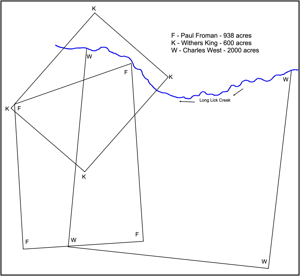
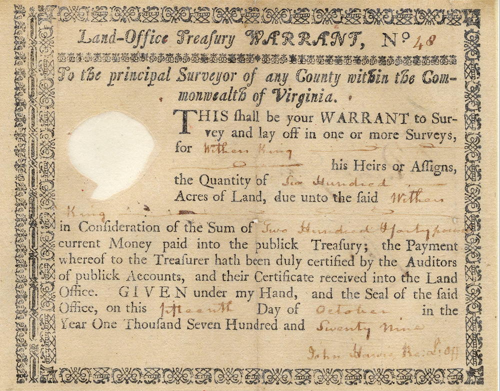
On 13 Feb 1783, Thomas Whitledge surveyed 600 acres for Withers King on the waters of Long Lick Creek. King received his deed for the land on 3 Jan 1786.
The surveyed tracts of Withers King, Paul Froman and Charles West along the upper reaches of Long Lick Creek overlap as shown on this drawing that is based on a survey conducted by Casper Herps by order of the Bullitt Circuit Court in an 1858 suit between Patterson, Moore and Company as plaintiff against George Magruder, defendant. The original survey is located in the T.C. Carroll plat cabinet in the county clerk's office. By original survey date, the King tract was the earliest surveyed.
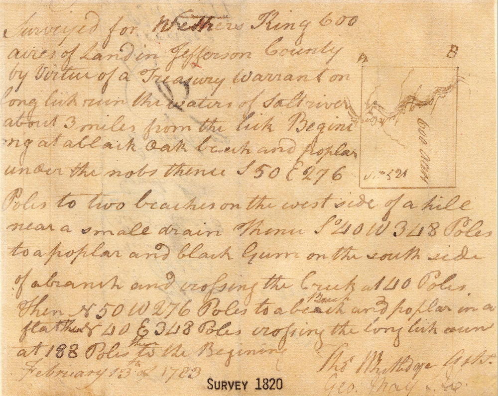
Survey
Surveyed for Withers King 600 acres of land in Jefferson County by virtue of a treasury warrant on Long Lick Run, the waters of Salt River, about 3 miles from the lick. Beginning at a black oak, beech and poplar under the knobs, thence S 50° E 276 poles to two beeches on the west side of a hill near a small drain, thence S 40° W 348 poles to a poplar and black gum on the south side of a branch and crossing the creek at 40 poles, then N 50° W 276 poles to a beech and poplar on a flat, thence N 40° E 348 poles crossing the Long Lick Run at 188 poles to the beginning. February 13th of 1783. Thomas Whitledge, surveyor.
Deed
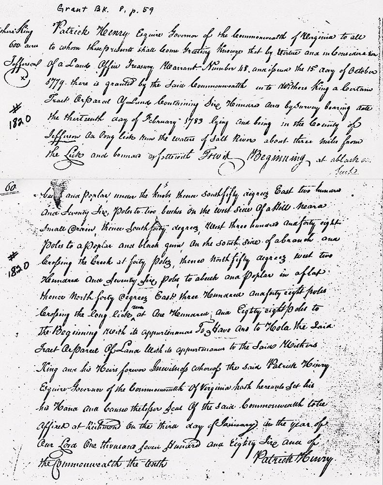
Virginia Grant Book 8, Page 59
Patrick Henry, Esquire, Governor of the Commonwealth of Virginia, to all to whom these presents shall come, greeting. Know ye that by virtue and in consideration of a land office treasury warrant Number 48, and issued the 15th day of October 1779, there is granted by the said Commonwealth unto Withers King a certain tract or parcel of land containing six hundred acres by survey bearing date the thirteenth day of February 1783, lying and being in the County of Jefferson on Long Lick Run, the waters of Salt River about three miles from the lick and bounded as followeth, to wit.
Beginning at a black oak, beech and poplar under the knobs, thence South 50° East 276 poles to two beeches on the west side of a hill near a small drain, thence South 40° West 348 poles to a poplar and black gum on the south side of a branch and crossing the creek at 40 poles, then North 50° West 276 poles to a beech and poplar on a flat, thence North 40° East 348 poles crossing the Long Lick Run at 188 poles to the beginning with its appurtenances, to have and to hold the said tract or parcel of land with its appurtenances to the said Withers King and his heirs forever. In witness whereof the said Patrick Henry, Esquire, Governor of the Commonwealth of Virginia hath hereunto set his hand and caused the lesser seal of the said Commonwealth to be affixed at Richmond on the third day of January in the year of our Lord one thousand seven hundred and eighty-six, and of the Commonwealth the tenth. (signed) Patrick Henry
Warrant
If you, the reader, have an interest in any particular part of our county history, and wish to contribute to this effort, use the form on our Contact Us page to send us your comments about this, or any Bullitt County History page. We welcome your comments and suggestions. If you feel that we have misspoken at any point, please feel free to point this out to us.
The Bullitt County History Museum, a service of the Bullitt County Genealogical Society, is located in the county courthouse at 300 South Buckman Street (Highway 61) in Shepherdsville, Kentucky. The museum, along with its research room, is open 10 a.m. to 4 p.m. Monday through Friday. Saturday appointments are available by calling 502-921-0161 during our regular weekday hours. Admission is free. The museum, as part of the Bullitt County Genealogical Society, is a 501(c)3 tax exempt organization and is classified as a 509(a)2 public charity. Contributions and bequests are deductible under section 2055, 2106, or 2522 of the Internal Revenue Code. Page last modified: 12 Jan 2024 . Page URL: bullittcountyhistory.org/bchistory/1080-withers-king.html