
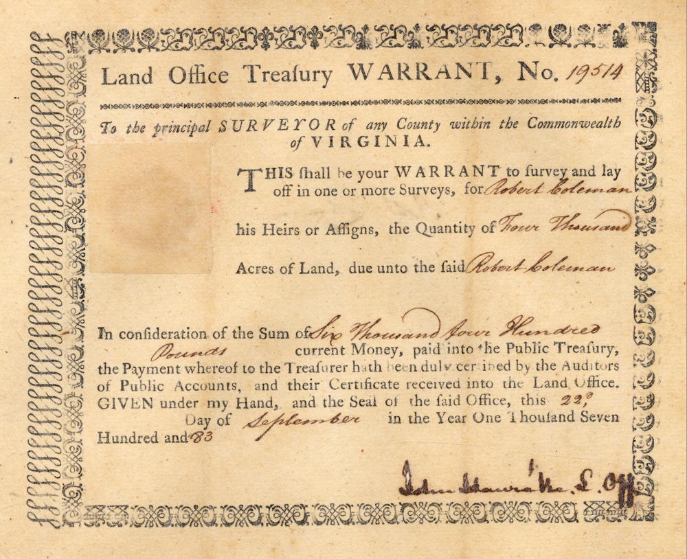
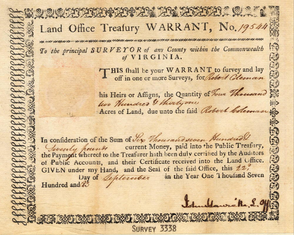
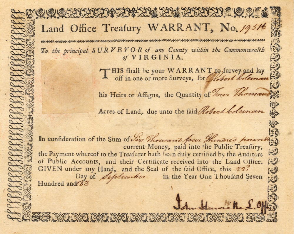
On 22 Sep 1783, Robert Coleman purchased three treasury warrants worth a total of 12,231 acres. That specific number suggests that he had somewhere specific in mind. Then on 16 Apr 1784, Daniel Sullivan completed a survey for exactly that number of acres in what was then Jefferson County, primarily in the knobs of present-day northwestern Bullitt County. Coleman's warrants and the original survey are shown below.
Warrant
Survey
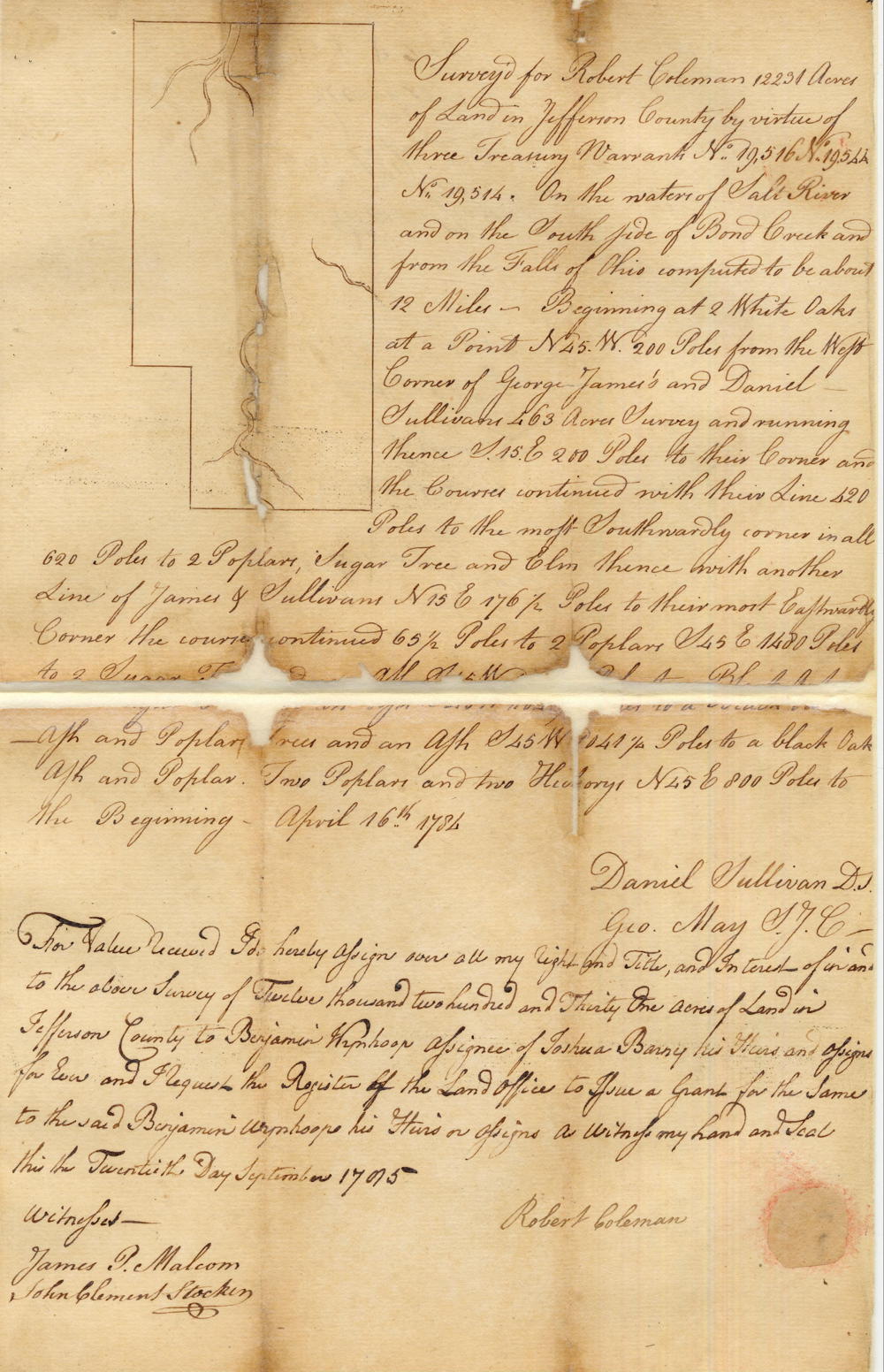
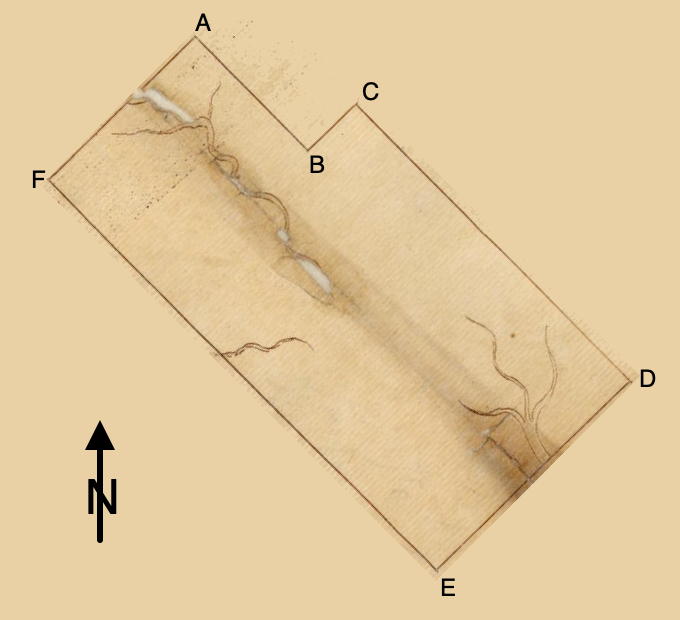
Surveyed for Robert Coleman 12231 acres of land in Jefferson County by virtue of three treasury warrants, No. 19516, 19544, and 19514 on the waters of Salt River and on the south side of Pond Creek and from the Fall of Ohio computed to be about 12 miles. Beginning at [A] two white oaks at a point N 45 W 200 poles from the West corner of George James and Daniel Sullivan's 463 acre survey, and running thence S 45 E 200 poles to their corner and the course continued with their line 420 poles to [B] the most southwardly corner, in all 620 poles [likely was closer to 520 poles], to two poplar, sugar tree, and elm, thence with another of James and Sullivan N 45 E 176 1/2 poles to [C] their most eastwardly corner, the course continued 65 1/4 poles to two poplars, S 45 E 1420 poles to [D] two sugar trees and an ash, S 45 W 1041 1/4 poles to [E] a black oak, ash and poplar, N 45 W 2000 to [F] two sugar trees, two poplar and two hickorys, N 45 E 800 poles to the beginning. April 16th 1784. Daniel Sullivan, deputy surveyor
For value received I do hereby assign our all my right and title and interest of in and to the above survey of twelve thousand two hundred and thirty one acres of land in Jefferson County to Benjamin Wynkoop, assignee of Joshua Barney, his heirs and assigns forever, and I request the register of the land office to issue a grant for the same to the said Benjamin Wynkoop, his heirs or assigns a witness of my hand and seal this the twentieth day September 1795. (signed) Robert Coleman. Witnesses: James P. Malcom, John Clement Stocken
As noted above, Coleman sold his title to this tract to Benjamin Wynkoop, and a deed was given to Wynkoop on 20 Feb 1786, as shown below. Then, in 1807, Joseph Wynkoop, heir of Benjamin Wynkoop dec'd, sold the entire tract to James Francis Moore and Joseph Brooks as shown on another page.
.Deed
Virginia Grant Book 4, pages 294-5
Patrick Henry Esquire, Governor of the Commonwealth of Virginia, to all to whom these presents shall come, greeting. Know ye that by virtue and in consideration of three land office treasury warrants numbers 19516, 19544 & 19514 and issued the twenty second day of September one thousand seven hundred and eighty three, there is granted by the said Commonwealth unto Benjamin Wynkoop, assignee of Joshua Barry who was assigned of Robert Coleman, a certain tract or parcel of land containing twelve thousand two hundred and thirty one acres by survey bearing date the sixteenth day of April one thousand seven hundred and eighty four lying and being in the county of Jefferson on the waters of Salt River, and on the south side of Pond Creek, and from the Falls of Ohio, computed to be about twelve miles, and bounded as followeth, to wit.
Beginning at two white oaks at a point North forty five degrees West two hundre poles from the west corner of George James & Daniel Sullivan's four hundred and sixty three acre survey and running thence South forty five degrees East two hunded poles to their corner and the course continued with their line four hundred & twenty poles to the most southwardly corner in all six hundred and twenty poles [likely was closer to 520 poles] to two poplars, sugar tree and elm, thence with another line of James's and Sullivan's North forty five degrees East one hundred seventy six and a half poles to their most eastwardly corner the course continued sixty five and a quarter poles to two poplars, South forty five degrees East fourteen hundred and eighty poles to two sugar trees and an ash, South forty five degrees West ten hundred forty one and a quarter poles to a black oak, ash and poplar, North fifty five degrees West two thousand poles to two sugar trees, two poplars and two hickories, North forty five degrees East eight hundred poles to the beginning, with its appurtenances to have and to hold the said tract or parcel of land with its appurtenances to the said Benjamin Wynkoop, and his heirs forever. In witness whereof the said Patrick Henry Esquire, Governor of the Commonwealth of Virginia, hath hereunto set his hand and caused the lesser seal of the said Commonwealth to be affixed at Richmond on the twentieth day of February in the year of our Lord one thousand seven hundred and eighty six and of the Commonwealth the tenth. (signed) P. Henry
If you, the reader, have an interest in any particular part of our county history, and wish to contribute to this effort, use the form on our Contact Us page to send us your comments about this, or any Bullitt County History page. We welcome your comments and suggestions. If you feel that we have misspoken at any point, please feel free to point this out to us.
The Bullitt County History Museum, a service of the Bullitt County Genealogical Society, is located in the county courthouse at 300 South Buckman Street (Highway 61) in Shepherdsville, Kentucky. The museum, along with its research room, is open 10 a.m. to 4 p.m. Monday through Friday. Saturday appointments are available by calling 502-921-0161 during our regular weekday hours. Admission is free. The museum, as part of the Bullitt County Genealogical Society, is a 501(c)3 tax exempt organization and is classified as a 509(a)2 public charity. Contributions and bequests are deductible under section 2055, 2106, or 2522 of the Internal Revenue Code. Page last modified: 12 Jan 2024 . Page URL: bullittcountyhistory.org/bchistory/benjamin-wynhoop.html