
Francis Shain and David Grable appear to have divided their 500 acre tract generally east and west with Grable taking 200 acres on the westward side. He then sold it to Isaac Collings in 1818, as shown below.
Following Isaac Collings' death the tract descended to his sons who appear to have made an arrangement with John H. Baker for the use of the tract as the site of the Crooked Creek furnace. This is indicated in a Bullitt Circuit Court case, and a later deed of the site to Quirey and Tyler.
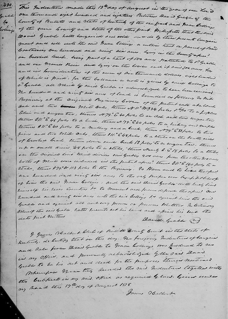
Bullitt County Deed Book C, Pages 480-481
This indenture made this 15th day of August in the year of our Lord 1818 between David Grable of the County of Bullitt and State of Kentucky of the one part and Isaac Collings of the same county and state of the other part. Witnesseth that the said David Grable hath bargained and sold and do by these presents bargain, grant and sell unto the said Isaac Collins a certain tract or parcel of land containing one hundred and ninety six acres lying in the county aforesaid on Crooked Creek, being part of a tract of 500 acres patented to said Grable and one Francis Shain, and lying on the lower end of said 500 acres, for and in consideration of the sum of $1000, $800 of which is paid, for the balance a note is given by said Collings to said Grable, all which by said Grable is acknowledged to have been received. The hundred and ninety six acres of land is bounded as follows, to wit. Beginning at the original beginning corner of the patent calls at a black oak and two white oaks, thence N 11° W 324 poles & 6/10 to a poplar, elm and sugar tree, thence N 79° E 40 poles to an ash and two sugar trees thence S 11° E 48 poles to a beech, thence N 79° E 40 poles to a hickory and maple, thence S 11° E 40 poles to a mulberry and a beech, thence N 79° E 33 poles to two pines and two white oaks, thence S 11° E 48 poles to a stake on the south side of Crooked Creek, thence down said creek 13 poles to a sugar tree, thence up a small drain 48 poles to a stake, thence nearly southeast 18 poles to a stake on the original line which divides said Grable's 200 acres from the other 300 acres both of which were included in the patent aforesaid, thence S 11° E 140 poles to a stake, thence S 79° W 113 poles to the beginning. To have and to hold the aforesaid 166 acres to the only proper use, benefit and behoof of him the said Isaac Collins, and the said David Grable doth hereby bind himself, his heirs, executors, &c to warrant and forever defend te aforesaid 196 acres unto the said Collings &c against him the said Grable and against all and every person or persons whatever. In testimony whereof the said Grable doth hereunto set his hand and affix his seal this date just written. (signed) David Grable
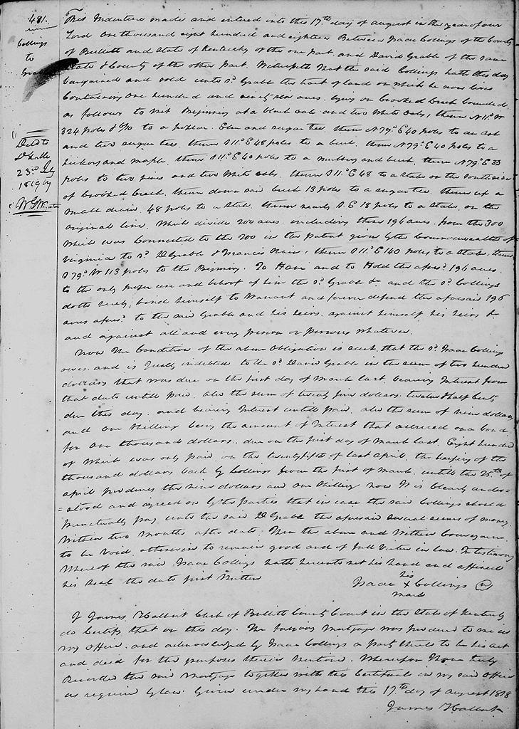
I James Halbert, clerk of Bullitt County Court in the state of Kentucky, do certify that on this day the foregoing indenture of bargain and sale from David Grable to Isaac Collings was produced to me in my office and personally acknowledged by the said David Grable to be his act and deed for the purpose therein mentioned. Wherefore I have truly recorded the said indenture together with this certificate in my said office as required by law. Given under my hand this 17th day of August 1818. (signed) James Halbert
This indenture made this 17th day of August in the year of our Lord 1818 between Isaac Collings of the County of Bullitt and State of Kentucky of the one part and David Grable of the same county and state of the other part. Witnesseth that the said Collings hath this day bargained and sold unto said Grable the tract of land on which he now lives containing 196 acres, lying on Crooked Creek, bounded as follows to wit. Beginning at a black oak and two white oaks, thence N 11° W 324 poles & 6/10 to a poplar, elm and sugar tree, thence N 79° E 40 poles to an ash and two sugar trees thence S 11° E 48 poles to a beech, thence N 79° E 40 poles to a hickory and maple, thence S 11° E 40 poles to a mulberry and a beech, thence N 79° E 33 poles to two pines and two white oaks, thence S 11° E 48 poles to a stake on the south side of Crooked Creek, thence down said creek 13 poles to a sugar tree, thence up a small drain 48 poles to a stake, thence nearly southeast 18 poles to a stake on the original line which divides 200 acres including these 196 acres from the 300 which was connected to the 200 in the patent given by the Commonwealth of Virginia to said D. Grable and Francis Shain, thence S 11° E 140 poles to a stake, thence S 79° W 113 poles to the beginning. To have and to hold the aforesaid 166 acres to the only proper use, benefit and behoof of him the said Grable &c, and the said Collings doth hereby bind himself to warrant and forever defend te aforesaid 196 acres aforesaid to the said Grable and his heirs against himself, his heirs and against all and every person or persons whatever.
Now the condition of the above obligation is such that the said Isaac Collings owes and is justly indebted to the said David Grable in the sum of $200 that was due on the first day of March last bearing interest from that date until paid. Also the sum of $25.12 1/2 due this day and bearing interest until paid. Also the sum of nine dollars and one shilling, being the amount of interest that accrued on a bond for $1000 each by Collings from the first of March until the 25th of April .. the nine dollars and one shilling, now it is clearly understood and agreed on by the parties that in case the said Collings should punctually pay unto the said D. Grable the aforesaid several sums of money within two months after date then the above and within conveyance to be void, otherwise to remain good and of full virtue in law. In testimony whereof te said Isaac Collings hath hereunto set his hand and affixed his seal the date first written. (signed) Isaac (his x mark) Collings.
If you, the reader, have an interest in any particular part of our county history, and wish to contribute to this effort, use the form on our Contact Us page to send us your comments about this, or any Bullitt County History page. We welcome your comments and suggestions. If you feel that we have misspoken at any point, please feel free to point this out to us.
The Bullitt County History Museum, a service of the Bullitt County Genealogical Society, is located in the county courthouse at 300 South Buckman Street (Highway 61) in Shepherdsville, Kentucky. The museum, along with its research room, is open 10 a.m. to 4 p.m. Monday through Friday. Saturday appointments are available by calling 502-921-0161 during our regular weekday hours. Admission is free. The museum, as part of the Bullitt County Genealogical Society, is a 501(c)3 tax exempt organization and is classified as a 509(a)2 public charity. Contributions and bequests are deductible under section 2055, 2106, or 2522 of the Internal Revenue Code. Page last modified: 12 Jan 2024 . Page URL: bullittcountyhistory.org/bchistory/grable-collings.html