
The following article was published in The Bullitt News, on 31 Dec 1909. It was written by J. R. Zimmerman (Louisville Courier-Journal, 5 Dec 1909 ). The photograph referred to in the opening paragraphs is shown at the end of the article.
Besides describing the Indian fight, the article details other adventures of Col. Patrick Brown and his brothers.
One hundred and fifteen years ago, last September, the last battle between the white settlers and the red men in this part of Kentucky was fought on Indian Run, in Bullitt County, about twelve miles southwest of Shepherdsville, and two miles southeast of the little town of Pitts Point.
The red men had raided Severns Valley, where Elizabethtown now stands and were on their way to Indiana, and unknown to them were pursued by a band of pioneers under the leadership of Col. Patrick Brown.
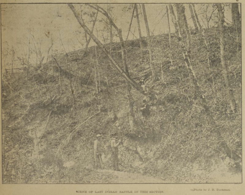
The evening before the conflict the Indians camped at a spring called the "Blue" spring, about two hundred yards from where the Indian Run empties into Rolling Fork where they were attacked next morning by Col. Brown and his brave followers. The white men were stationed on the bluff shown in the picture, while the red men were down on the level ground, about where the man is seen with the rifle on his shoulder. So unerring was the aim of the white men, and so bravely did the Indians fight, that only one red warrior escaped, and only three of the white men were killed.
The manuscript from which the history of this battle is obtained was written by the late Alfred Brown of Elizabethtown, who got the story from William Brown, brother of Col. Patrick Brown. It was prepared for the late Judge W. R. Thompson, of Shepherdsville, and was given to the writer by John V. Thompson, son of Judge Thompson. It is here set out in full:
"One of the historic places in Bullitt County is Brown's Run, a little branch that empties into the Rolling Fork just above its junction with Salt River.
"It is the place of a fight with the Indians in 1794, which was the last invasion made by them in this part of Kentucky. A party of twelve or fifteen Indians visited Severns Valley and did some mischief. What was then known as Severns Valley is the valley in which Elizabethtown in Hardin County, is located. Col. Patrick Brown, and about fourteen or fifteen others undertook to pursue the Indians and punish them. They took up their trail in the evening and pursued it until they saw where the Indians had gone down into the Rolling Fork; this being about sundown the party concluded to camp there that night. As soon as it was light the next morning, they took up the trail and found where the Indians had gone down the Fork for a short distance and had come ashore on the opposite side; upon reaching the opposite side of the river they did not go far when they came up with the Indians, who had camped between the banks of the little branch now known as Brown's Run. The whites got the first fire; a hand to hand fight ensued; all the Indians were killed except one. Three of the whites were killed; one was Mr. Vertrees, another Mr. Ashcroft, and the name of the third is not remembered. John Walters was wounded in the shoulder and in the wrist, and from him this information was obtained. His descendants are numerous and are scattered over Larue and Harding counties. The relatives of Ashcraft and of Vertrees are numerous in what is now Larue and Hardin counties, and well may they be proud of their ancestors who fell in this little fight.
"Patrick Brown, after whom Brown's Run is named and made memorable on account of this sharp fight with the Indians, was the leader of the whites in their pursuit of their savage foes, and he was for years the leader of the whites in all the military excursions from Severns Valley. He was from Hanover County, Virginia and came to Kentucky with his brother William Brown in 1782 and reached Harrod's Station July 29th of that year. He took part in several military expeditions from the time he came in 1782 until the end of the Indian hostilities in 1794. As it has been said, he and his brother William reached Harrod's Station on July 29, 1782, and there met for the first time in over two years, their brother, James Brown, who had come to Kentucky about the close of the year 1779, and on the next day James Brown left; and the next time Patrick Brown and his brother William saw their brother James he was among the dead who had fallen on August 18, 1782, at the battle of the Blue Licks. Patrick Brown and his brother William were with Gen. Logan, and reached the place of the conflict after the fight was over and the enemy gone.
"In St. Clair's defeat, while retreating, Patrick Brown sprained his knee and was unable to travel. The beaten and disheartened forces of St. Clair were hotly pursued by their savage foes, and Patrick Brown, believing that he would surely lose his life as the Indians searched the route of their retreating enemy when they retraced their steps, requested his comrades to kill him, which they refused to do but hid him as well as they could a little off the trail, and left him with a gun and ammunition. After Patrick Brown had been left, the whites were so hard pressed that they left behind them some whiskey, and the Indians, in retracing their steps, when they came across this whisky got drunk, which made them less vigilant in their search, and Patrick Brown escaped. After the lapse of some days he reached the settlements, having fed himself by the aid of his gun.
"Patrick Brown represented Hardin County in the Constitutional Convention of 1799, and wanted to make Kentucky a non-slave holding State, but failed in that and when he returned to his home on the west fork of the Nolynn, about three miles north of the present town of Hodgenville, he set his negroes (of which he had quite a number) free, and in 1814 moved to a farm near the present town of Madison, Ind., where in 1835, he died, and where will be found the marble which marks his grave.
"There will be found in a publication called "The Wilderness Road' made by the Filson Club and written by Mr. Thomas Speed, one of its members, a memorandum kept by William Brown, when he and his brother Patrick came to Kentucky in 1782. It tells the exact route they came, which was by Boone's trace, and gives a clear account of the officers killed in the battle of the Blue Licks. Said publication also has a copy of William Brown's itinerary when he came to Kentucky in 1790 down the Ohio River, in which Mr. Brown gives the location of every island between Pittsburg and the mouth of Limestone (Maysville is at the mouth of Limestone), and tells on which side of each island the channel was.
"William Brown remained for a time in Kentucky after his arrival in 1782, and then returned to Virginia to secure land for himself and his brother Patrick; and he had patented to himself in 1784 a large tract of land on the west fork of Nolynn about three miles north of where the present town of Hodgenville stands, which he divided with his brother Patrick, and located on the other half himself and under an oak selected by himself on that tract of land his remains were buried in 1825."
It will be observed that the manuscript speaks of Brown's run as the one on which the battle was fought, but this is not true, as Brown's Run is three miles north of Indian Run and empties into Salt River, while the manuscript says the stream on which the battle took place empties into the Rolling Fork, and as Indian Run is the only stream in that vicinity of any size that empties into Rolling Fork, it is bound to be the one on which the fight took place; besides, the exact location of the battlefield has been known locally ever since it occurred. It has lived in the legendary history of that locality, and father has shown the place to son from one generation to another so that the situs is fixed with unassailable certainty.
Somewhere near "Blue" spring twelve or fourteen red men are buried, but so far as I can learn no one has ever pointed out the exact spot, but they were given burial by Col. Brown and his men. The battlefield is overgrown with shrubs and briars, the forest trees are scattered here and there, but there is not much save the tall bluff and little spring and the solitude of the gloomy ravine to indicate that it was the scene of a sanguinary conflict between aboriginals and Anglo- Saxons before the birth of our beloved Commonwealth.
J. R. Zimmerman (Louisville Courier-Joumal)
The approximate location of this battle is shown on the map below.
Originally published in The Bullitt News, 31 Dec 1909. Transcribed here from microfilm, with reference to the same story transcribed by Anthony Foster, and published in the Wilderness Road, Volume 20, Number 3, March 2008, pages 73-4.
If you, the reader, have an interest in any particular part of our county history, and wish to contribute to this effort, use the form on our Contact Us page to send us your comments about this, or any Bullitt County History page. We welcome your comments and suggestions. If you feel that we have misspoken at any point, please feel free to point this out to us.
The Bullitt County History Museum, a service of the Bullitt County Genealogical Society, is located in the county courthouse at 300 South Buckman Street (Highway 61) in Shepherdsville, Kentucky. The museum, along with its research room, is open 10 a.m. to 4 p.m. Monday through Friday. Saturday appointments are available by calling 502-921-0161 during our regular weekday hours. Admission is free. The museum, as part of the Bullitt County Genealogical Society, is a 501(c)3 tax exempt organization and is classified as a 509(a)2 public charity. Contributions and bequests are deductible under section 2055, 2106, or 2522 of the Internal Revenue Code. Page last modified: 12 Jan 2024 . Page URL: bullittcountyhistory.org/bchistory/lastindianfight.html