
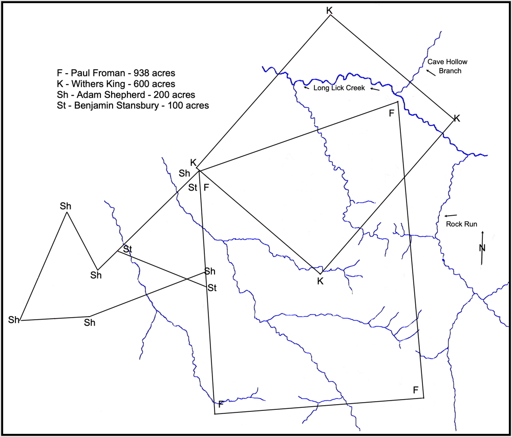
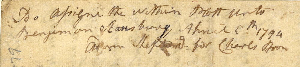
On 14 Jun 1792, Benjamin Stansbury surveyed 100 acres for Charles Boone on the waters of Long Lick Creek. Boone later assigned the tract to Stansbury who obtained his deed to the land on 1 Oct 1796. After Benjamin had deeded his lands to his children, and then regained them, this tract was sold by the Sheriff to pay a debt he owed to Henry Horine. William Caldwell was the purchaser at that time. Later he sold it, along with other tracts, to Francis Maraman.
Adam Shepherd's 200 acre survey, done in 1798, partly overlay Benjamin Stansbury's 1792 survey of 100 acres as shown on this drawing, copied from a survey done to divide the land of Archibald Magruder amongst his heirs in 1863.
Survey
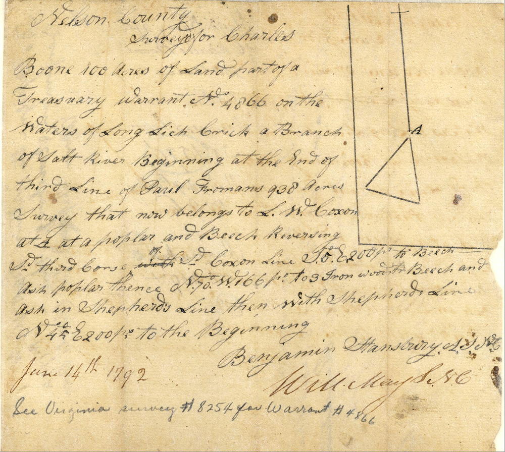
Nelson County. Surveyed for Charles Boone 100 acres of land, part of a treasury warrant No. 4866 on the waters of Long Lick Creek, a branch of Salt River, beginning at the end of third line of Paul Froman's 938 acres survey that now belongs to L. W. Coxon [likely Leven Wilcoxon] at a poplar and beech reversing said third course of said Coxon's line S 5° E 200 poles to beech, ash, poplar, thence N 70° W 166 poles to 3 ironwoods, beech and ash in Shepherd's line then with Shepherd's line N 45° E 200 poles to the beginning. June 14th 1792. Benjamin Stansbury, surveyor (See Virginia survey #8254 for warrant #4866.)
Deed
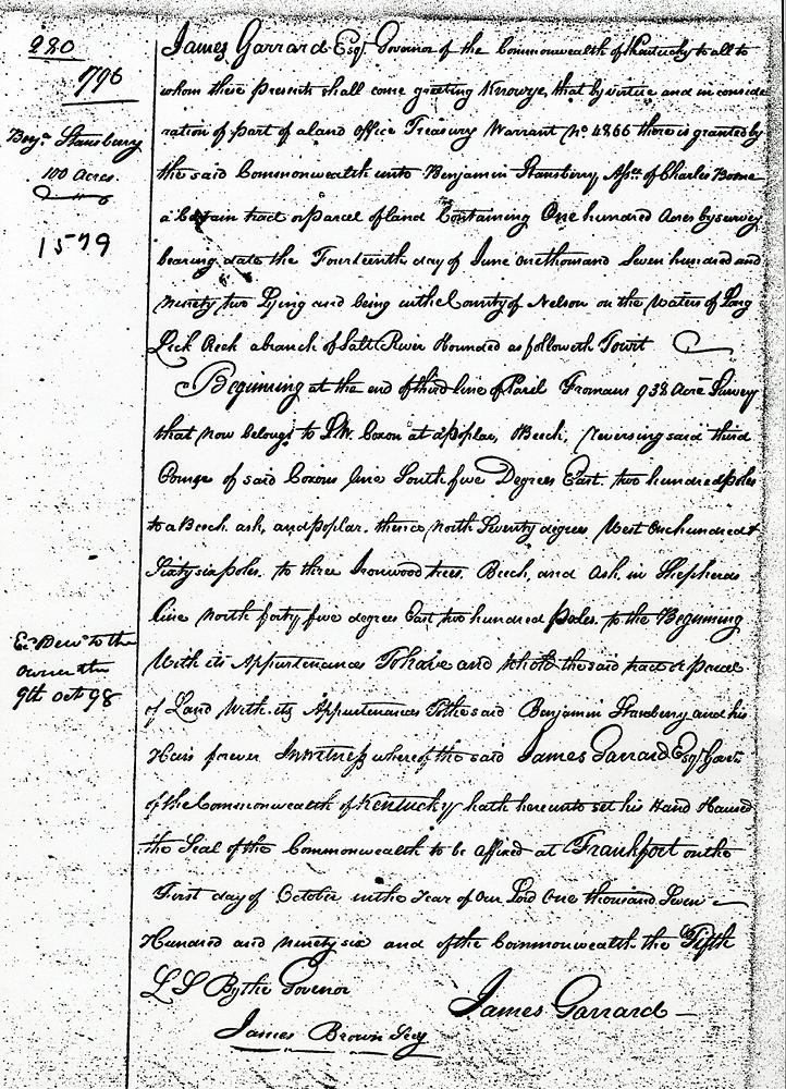
James Garrard Esquire, Governor of the Commonwealth of Kentucky to all to whom these presents shall come, greeting. Know ye that by virtue and in consideration of part of a land office treasury warrant No. 4866 there is granted by the said Commonwealth unto Benjamin Stansbury, assignee of Charles Boone, a certain tract or parcel of land containing one hundred acres by survey bearing date the fourteenth day of June one thousand seven hundred and ninety-two, lying and being within the county of Nelson on the waters of Long Lick Creek, a branch of Salt River, and bounded as followeth, to wit.
Beginning at the end of the third line of Paul Froman's 938 acre survey that now belongs to L. W. Coxon at a poplar and beech, reversing said third course of said Coxon's line South five degrees East two hundred poles to a beech, ash and poplar, thence North seventy degrees West one hundred and sixty-six poles to three ironwood trees, beech and ash in Shepherd's line, North forty-five degrees East two hundred poles to the beginning, with its appurtenances, to have and to hold the said tract or parcel of land with its appurtenances to the said Benjamin Stansbury and his heirs forever. In witness whereof the said James Garrard, Esquire, Governor of the Commonwealth of Kentucky, hath hereunto set his hand and caused the seal of the Commonwealth to be affixed at Frankfort on the first day of October in the year of our Lord one thousand seven hundred and ninety-six, and of the Commonwealth the fifth. (signed) James Garrard, by James Brown, secretary.
If you, the reader, have an interest in any particular part of our county history, and wish to contribute to this effort, use the form on our Contact Us page to send us your comments about this, or any Bullitt County History page. We welcome your comments and suggestions. If you feel that we have misspoken at any point, please feel free to point this out to us.
The Bullitt County History Museum, a service of the Bullitt County Genealogical Society, is located in the county courthouse at 300 South Buckman Street (Highway 61) in Shepherdsville, Kentucky. The museum, along with its research room, is open 10 a.m. to 4 p.m. Monday through Friday. Saturday appointments are available by calling 502-921-0161 during our regular weekday hours. Admission is free. The museum, as part of the Bullitt County Genealogical Society, is a 501(c)3 tax exempt organization and is classified as a 509(a)2 public charity. Contributions and bequests are deductible under section 2055, 2106, or 2522 of the Internal Revenue Code. Page last modified: 12 Jan 2024 . Page URL: bullittcountyhistory.org/bchistory/ok1579-stansbury.html