
This 700 acre tract across Salt River from the mouth of Long Lick Creek was first entered in the name of William Farmer on 29 Jun 1780, although the survey by Benjamin Stansbury was not completed until 6 Oct 1796. It covered much of the same land as that of Jacob Froman, but was entered first ahead of Froman's entry. On 12 Nov 1785, Farmer assigned the entry over to Nicholas Meriweather who later signed it over to Phillip Buckner on 17 Apr 1793. Buckner obtained his deed to the land on 23 Jul 1798. Buckner would later sell part of this land to Jonathan Irons.
Survey
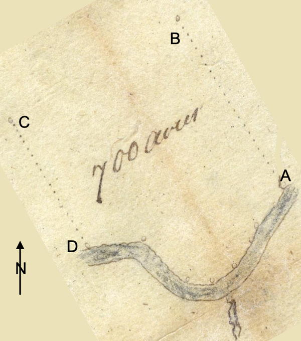
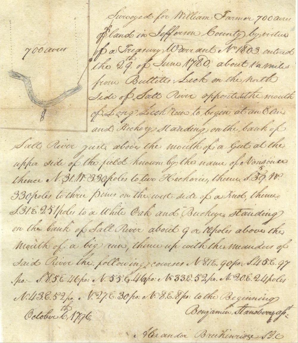
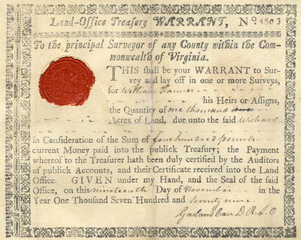
Surveyed for William Farmer 700 acres of land in Jefferson County by virtue of a treasury warrant number 1803 entered the 29th day of June 1780 about 1 1/2 miles from Bullitt's Lick on the north side of Salt River opposite the mouth of Long Lick run to begin at [A] an elm and hickory standing on the bank of Salt River just above the mouth of a gut at the upper side of the field known by the name of Nonsense, thence North 31° West 330 poles to [B]two hickorys, thence South 39° West 330 poles to [C]three pines on the west side of a knob, thence South 31° East 251 poles to [D]a white oak and buckeye standing on the bank of Salt River about 9 or 10 poles above the mouth of a big run, thence up with the meanders of said river the following courses North 81° East 90 poles, South 45° East 97 poles, South 85° East 46 poles, North 55° East 46 poles, North 33° East 52 poles, North 20° East 24 poles, North 43° East 52 poles, North 27° East 30 poles, North 8° East 8 poles to the beginning. October the 6th 1796. Benjamin Stansberry, assistant surveyor.
Survey Back
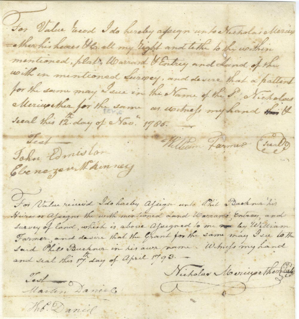
For value received I do hereby assign unto Nicholas Meriwether his heirs etc. all my right and title to the within mentioned plat, warrant and entry and land of the within mentioned survey and devise that a patent for the same may issue in the name of the said Nicholas Meriweather for the same as witness my hand and seal this 12th day of November 1785. (signed) William Farmer. Teste: John Edmiston & Ebenezer McKenney.
For value received I do hereby assign unto Phil Buckner his heirs or assigns the within mentioned land, warrant, entry and survey of land which is above assigned to me by William Farmer and desire that the grant for the same may issue to the said Phil Buckner in his own name. Witness my hand and seal the 17th day of April 1793. (signed) Nicholas Meriweather. Teste: Martin Daniel, Thomas Daniel.
Deed
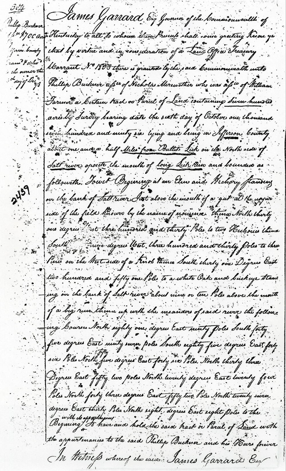
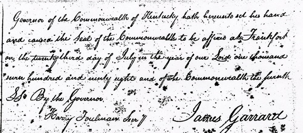
James Garrard Esquire, Governor of the Commonwealth of Kentucky, to all to whom these presents shall come, greeting. Know ye that by virtue and in consideration of a land office treasury warrant number 1803 there is granted by the said Commonwealth onto Phillip Buckner assignee of Nicolas Mirewether who was assignee of William Farmer a certain tract or parcel of land containing 700 acres by survey bearing date the 6th day of October 1796, lying and being in Jefferson County about one and a half miles from Bullitt's Lick on the north side of Salt River opposite the mouth of Long Lick Run and bounded as followeth to wit. Beginning at an elm and hickory standing on the bank of Salt River just above the mouth of a gut at the upper side of the field known by the name of Nonsense, thence North 31° West 330 poles to two hickories, thence South 39° West 330 poles to three pines on the west side of a knob, thence South 31° East 251 poles to a white oak and buckeye standing on the bank of Salt River about 9 or 10 poles above the mouth of a big run, thence up with the meanders of said river the following courses North 81° East 90 poles, South 45° East 97 poles, South 85° East 46 poles, North 55° East 46 poles, North 33° East 52 poles, North 20° East 24 poles, North 43° East 52 poles, North 27° East 30 poles, North 8° East 8 poles to the beginning with its appurtenances to have and to hold the said tract or parcel of land with the appurtenances to the said Phillip Buckner and his heirs forever. In witness whereof the said James Garrard Esquire, Governor of the Commonwealth of Kentucky, hath hereunto set his hand and caused the seal of the Commonwealth to be affixed at Frankfort on the 23rd day of July in the year of our Lord 1798 and of the Commonwealth the seventh. (signed) James Garrard
Warrant
If you, the reader, have an interest in any particular part of our county history, and wish to contribute to this effort, use the form on our Contact Us page to send us your comments about this, or any Bullitt County History page. We welcome your comments and suggestions. If you feel that we have misspoken at any point, please feel free to point this out to us.
The Bullitt County History Museum, a service of the Bullitt County Genealogical Society, is located in the county courthouse at 300 South Buckman Street (Highway 61) in Shepherdsville, Kentucky. The museum, along with its research room, is open 10 a.m. to 4 p.m. Monday through Friday. Saturday appointments are available by calling 502-921-0161 during our regular weekday hours. Admission is free. The museum, as part of the Bullitt County Genealogical Society, is a 501(c)3 tax exempt organization and is classified as a 509(a)2 public charity. Contributions and bequests are deductible under section 2055, 2106, or 2522 of the Internal Revenue Code. Page last modified: 12 Jan 2024 . Page URL: bullittcountyhistory.org/bchistory/ok2439-buckner.html