
Benjamin Stansbury was chosen to lay out the first plan for Shepherdsville. Then in 1809, Bullitt County Surveyor James Shanks was asked to reestablish the town's plat lines. All of this was recorded in Deed Book B, and is shown below with our transcriptions. Information about the sales of lots in the new town may be found on another page.
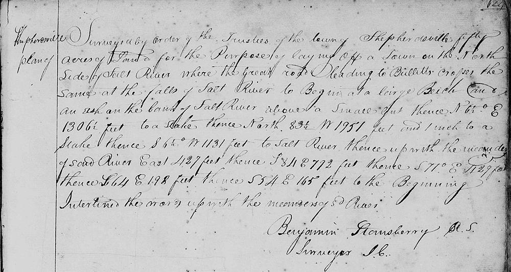
Bullitt County Deed Book B, Page 624
Surveyed by order of the trustees of the town of Shepherdsville fifty acres of land for the purpose of laying off a town on the north side of Salt River where the great road leading to Bullitt's crosses the same at the falls of Salt River to begin at a large beech and an ash on the bank of Salt River above a small gut, thence N 6 1/2° E 1306 1/2 feet to a stake, thence North 83 1/2° W 1951 feet and 1 inch to a stake, thence S 6 1/2° W 1131 feet to Salt River, thence up with the meanders of said river East 427 feet, thence S 84° E 792 feet, thence S 71° E 429 feet, thence S 64° E 198 feet, thence S 54° E 165 feet to the beginning. - Benjamin Stansbury
Page 625
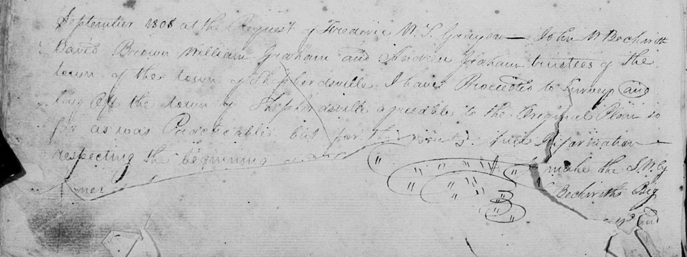
September 1808, at the request of Frederic W. S. Grayson, John W. Beckwith, David Brown, William Graham and Andrew Graham, trustees of the town of Shepherdsville I have proceeded to survey and lay off the town of Shepherdsville agreeable to the original plan as far as was practicable; but for the [page torn] full information respecting the beginning [page torn] make the [rest of page missing].
Page 626
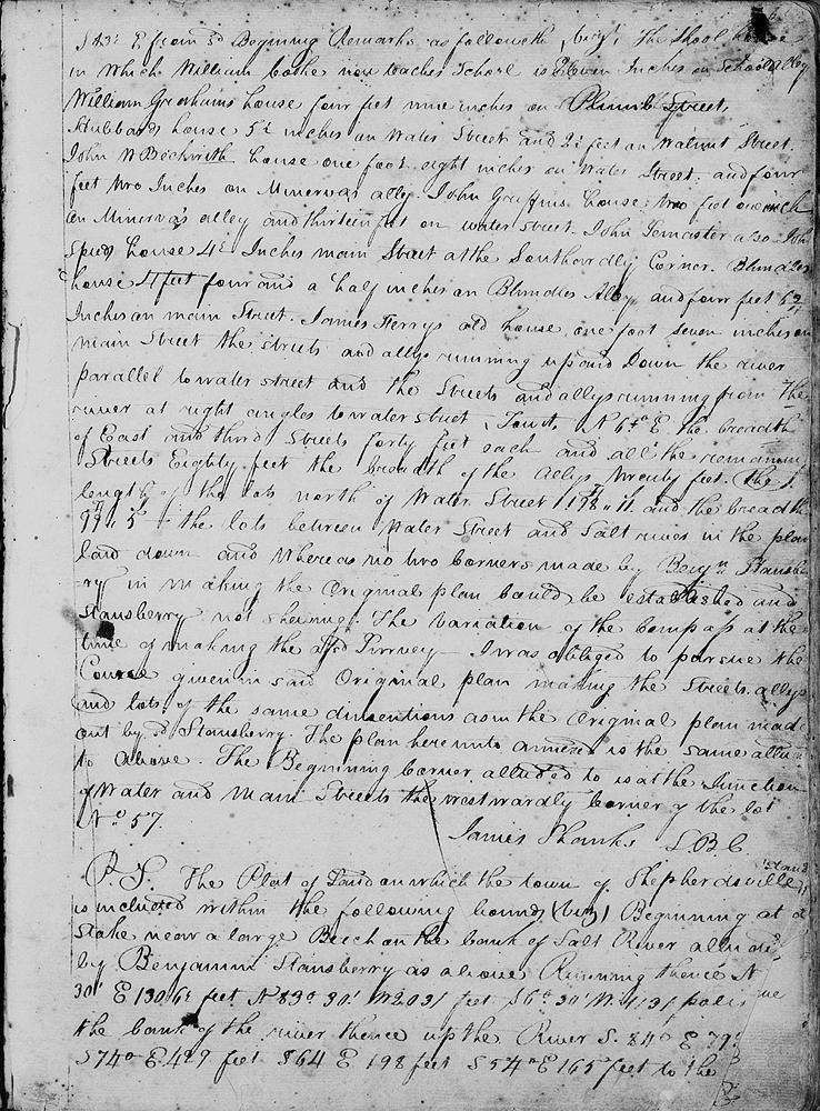
S 83 1/2° from said beginning. Remarks as followeth, viz: The school house in which William Cooke now teaches school is eleven inches on School Alley. William Graham's house four feet nine inches on Plumb Street. Hubbard's house 5 1/2 inches on Water Street and 2 1/2 feet on Walnut Street. John W. Beckwith house one foot eight inches on Water Steet and four feet two inches on Minerva's Alley. John Griffin's house two feet one inch on Minerva's Alley and thirteen feet on Water Street. John Lemaster also John Speed's house 4 1/2 inches on Main Street at the southwardly corner. Blunder's house 4 feet four and a half inches on Blunder's Alley and four feet 6 3/4 inches on Main Street. James Ferry's old house one foot seven inches on Main Street.
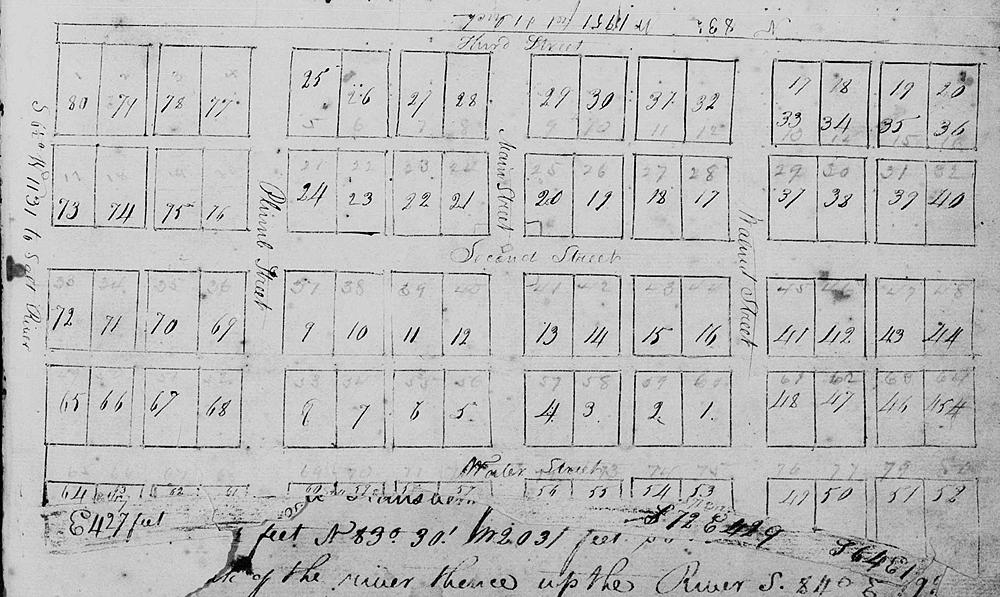
The streets and alleys running from the river at right angles to Water Street, to wit, N 6 1/2° E. The breadth of East and Third Streets forty feet each, and all the remaining streets eighty feet. the breadth of the alleys twenty feet. The length of the lots north of Water Street 198' 11" and the breadth 99' 5". The lots between Water Street and Salt River in the plan, and whereas no two corners made by Benjamin Stansbury in making the original plan could be established and Stansbury not showing the variation of the compass at the time of making the aforesaid survey, I was obliged to pursue the course given in said original plan, making the streets, alleys and lots of the same dimensions as in the original plan made out by said Stansbury. The plan hereunto annexed is the same alluded to above. The beginning corner alluded to is at the junction of Water and Main Street, the westwardly corner of the lot No. 57. (signed) James Shanks, S.B.C.
The plat of land on which the town of Shepherdsville stands is included within the following bounds (viz) Beginning at a stake near a large beech on the bank of Salt River alluded to by Benjamin Stansbury as above. Running thence N 6° 30" E 1306 1/2 feet, N 83° 30" W 2031 feet, S 6° 30" W 1131 poles [feet] to the bank of the river, thence up the river S 84° E 792 feet, S 74° E 429 feet, S 64° E 198 feet, S 54° E 165 feet to the beginning.
Page 627
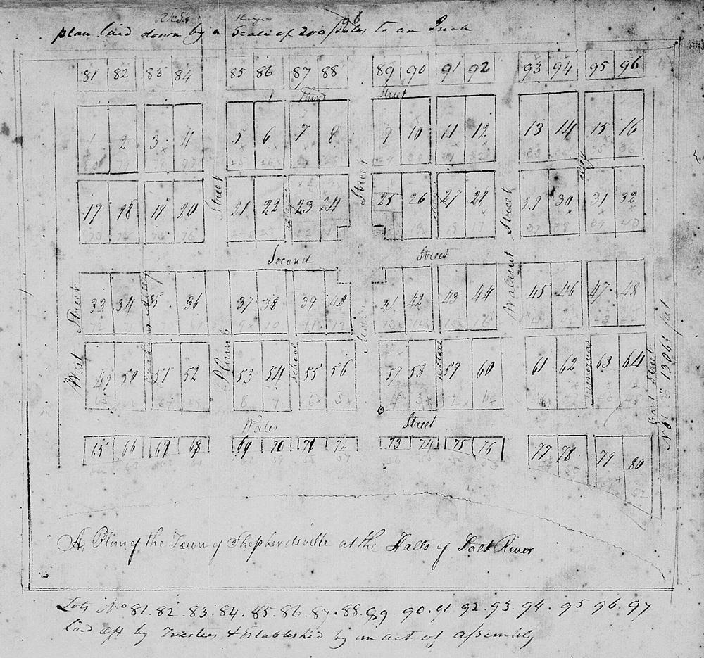
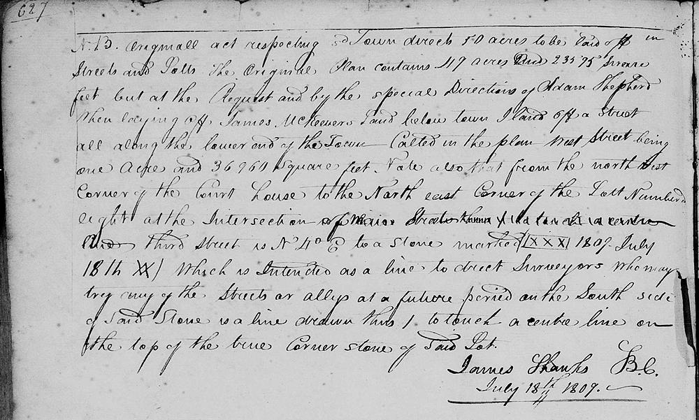
N.B. Original act respecting said town directs 50 acres to be laid off in streets and lots. The original plan contains 49 acres and 23575 square feet, but at the request, and by the special directions of Adam Shepherd when laying off James MKeever's land below town, I laid off a street all along the lower end of the town, called in the plan West Street, being one acre and 36960 square feet. Note also that from the northwest corner of the court house to the northeast corner of lot numbered eight at the intersection of Third Street is N 4° E to a stone marked ([xxx] 1807 July 18th XX) which is intended as a line to direct surveyors who may try any of the streets or alleys at a future period on the south side of said stone is a line drawn thus / to touch a center line on the top of the true corner stone of said lot. (signed) James Shanks, S.B.C., July 18th 1809.
If you, the reader, have an interest in any particular part of our county history, and wish to contribute to this effort, use the form on our Contact Us page to send us your comments about this, or any Bullitt County History page. We welcome your comments and suggestions. If you feel that we have misspoken at any point, please feel free to point this out to us.
The Bullitt County History Museum, a service of the Bullitt County Genealogical Society, is located in the county courthouse at 300 South Buckman Street (Highway 61) in Shepherdsville, Kentucky. The museum, along with its research room, is open 10 a.m. to 4 p.m. Monday through Friday. Saturday appointments are available by calling 502-921-0161 during our regular weekday hours. Admission is free. The museum, as part of the Bullitt County Genealogical Society, is a 501(c)3 tax exempt organization and is classified as a 509(a)2 public charity. Contributions and bequests are deductible under section 2055, 2106, or 2522 of the Internal Revenue Code. Page last modified: 12 Jan 2024 . Page URL: bullittcountyhistory.org/bchistory/shanks-shep-plat.html