
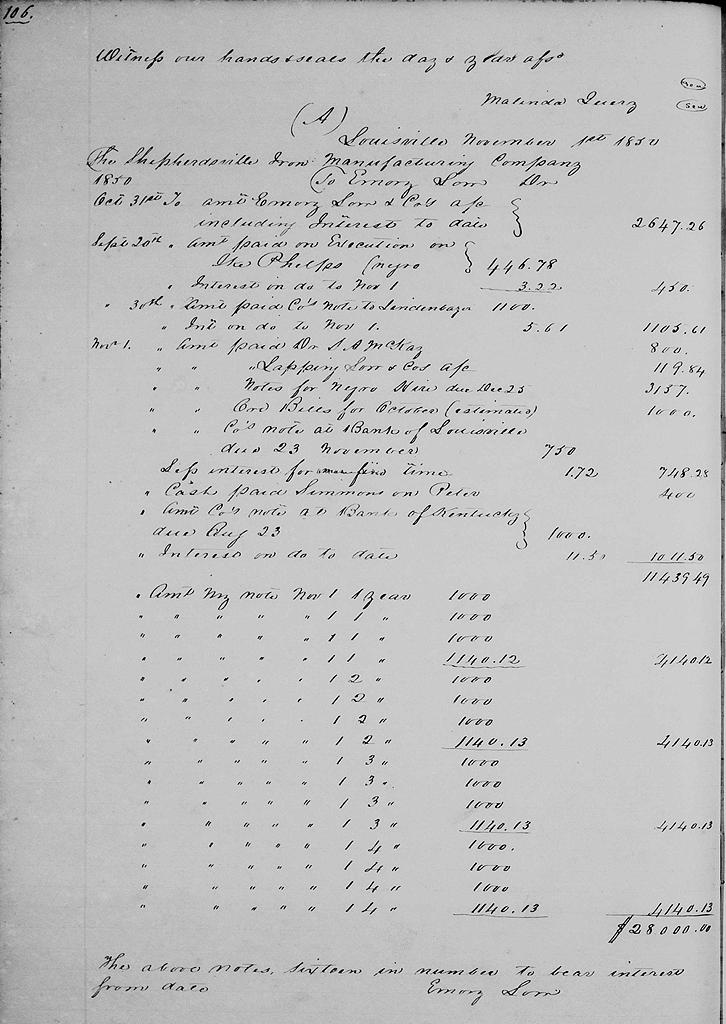
On 4 Nov 1850, the Shepherdsville Iron Manufacturing Company sold four tracts to Emory Low, a Louisville merchant. The tracts included half of the 7880 acres sold by John Pope and wife to John H. Baker and Thomas Joyce that included the Salt River furnace, 200 acres that included the Crooked Creek furnace, the 5000 acre Railey tract, and the 2000 acre Charles West tract. Not included was the 450 acres near Shepherdsville, called the forge tract.
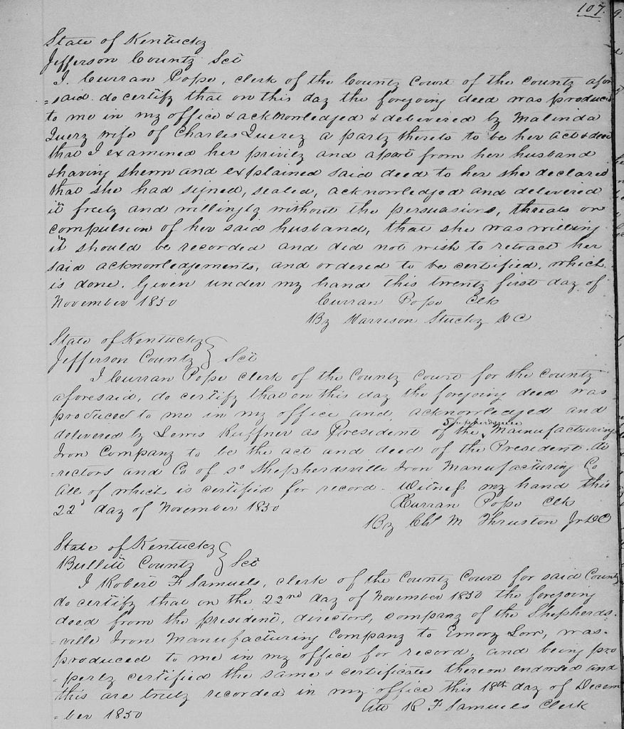
Bullitt County Deed Book M, pages 103-107
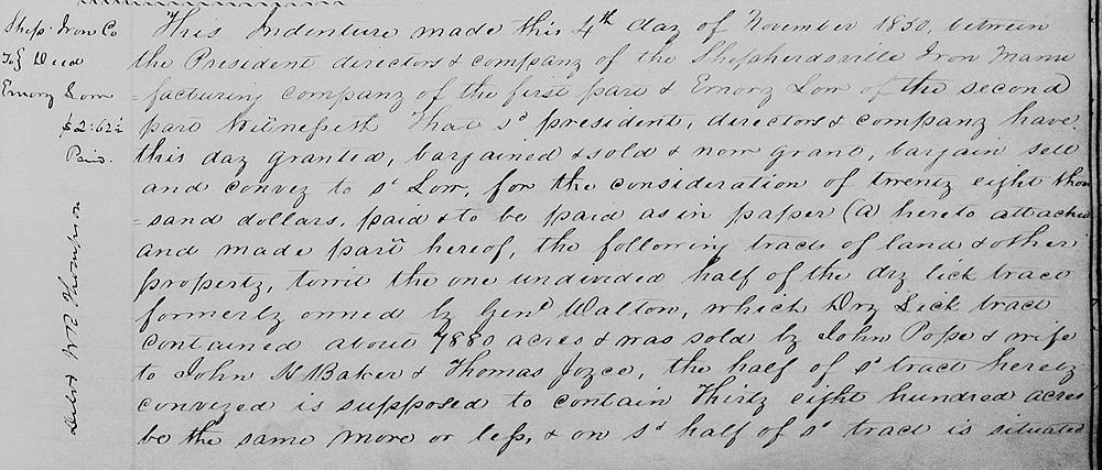
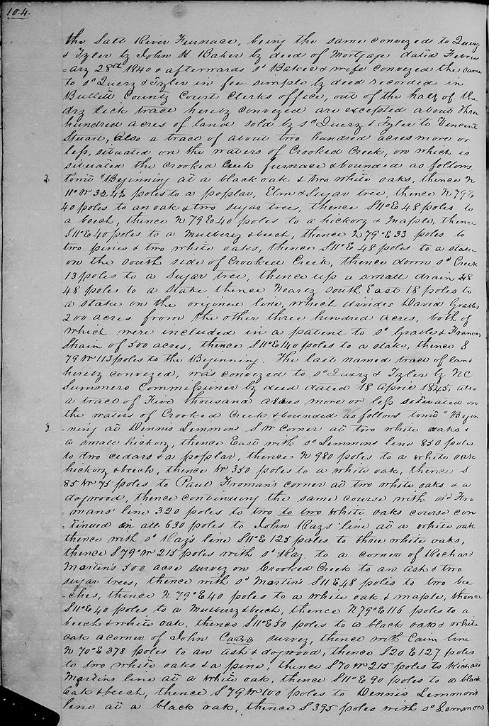
This indenture made this 4th day of November 1850 between the President, directors & company of the Shepherdsville Iron Manufacturing company of the first part & Emory Low of the second part. Witnesseth that said president, directors and company have this day granted, bargained and sold, and now grant, bargain, sell and convey to said Low for the consideration of $28,000, paid or to be paid as in paper (A) hereto attached and made part hereof, the following tracts of land & other property, to wit, the one undivided half of the Dry Lick tract, formerly owned by General Walton, which Dry Lick tract contained about 7880 acres and was sold by John Pope and wife to John H. Baker and Thomas Joyce, the half of said tract herein conveyed is supposed to contain 3800 acres, be the same more or less, and on said half of said tract is situated the Salt River Furnace, being the same conveyed to Quirey & Tyler by John H. Baker by deed of mortgage dated February 28th 1840 and afterwards said Baker & wife conveyed the same to said Quirey & Tyler in fee simple by deed recorded in Bullitt County Court Clerk's office, out of the half of the Dry Lick tract herein conveyed are excepted about 300 acres of land sold by said Quirey & Tyler to Vincent Stuart.
Also a tract of about 200 acres more or less situated on the waters of Crooked Creek, on which is situated the Crooked Creek Furnace and bounded as follows, to wit.
"Beginning at a black oak & two white oaks, thence N 11° W 324.6 poles to a poplar, elm and sugar tree, thence N 79° E 40 poles to an oak and two sugar trees, thence S 11° E 48 poles to a beech, thence N 79° E 40 poles to a hickory and maple, thence S 11° E 40 poles to a mulberry and beech, thence N 79° E 33 poles to two pines and two white oaks, thence S 11° E 48 poles to a stake on the south side of Crooked Creek, thence down said creek 13 poles to a sugar tree, thence up a small drain 48 poles to a stake, thence nearly southeast 18 poles to a stake on the original line which divides David Grable's 200 acres from the other 300 acres, both of which were included in a patent to said Grable and Francis Shain of 500 acres, thence S 11° E 140 poles to a stake, thence S 79° W 113 poles to the beginning." The last named tract of land herein conveyed was conveyed to said Quirey & Tyler by N. C. Summers, commissioner, by deed dated 18 April 1845.
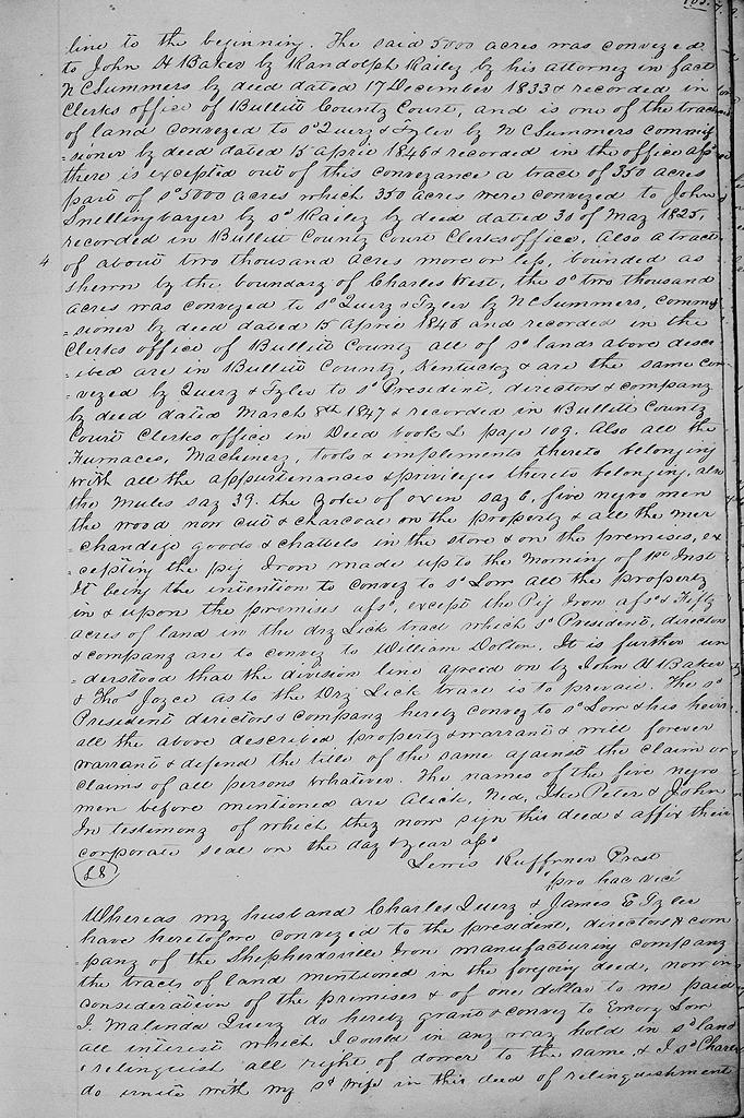
Also a tract of 5000 acres more or less situated on the waters of Crooked Creek and bounded as follows, to wit. "Beginning at Dennis Lenham's southwest corner at two white oaks and a small hickory, thence East with said Lenham's line 850 poles to two cedars and a poplar, thence North 980 poles to a white oak, hickory and beech, thence West 350 poles to a white oak, thence S 85° W 75 poles to Paul Froman's corner at two white oaks and a dogwood, thence continuing the same course with said Froman's line 320 poles to two white oaks course continued in all 630 poles to John Ray's line at a white oak, thence with said Ray's line S 11° E 125 poles to three white oaks, thence S 79° W 215 poless with said Ray to a corner of Richard Morton's 500 acre survey on Crooked Creek to an ash and two sugar trees, thence with said Morton's S 11° E 48 poles to two beeches, thence N 79° E 40 poles to a white oak and maple, thence S 11° E 40 poles to a mulberry and beech, thence N 79° E 116 poles to a beech and white oak, thence S 11° E 50 poles to a black oak and white oak, a corner of John Cain's survey, thence with Cain's line N 70° E 378 poles to an ash and dogwood, thence S 20° E 127 poles to two white oaks and a pine, thence S 70° W 215 poles to Richard Morton's line at a white oak, thence S 11° E 90 poles to a black oak and beech, thence S 79° W 100 poles to Dennis Lenham's line at a black oak, thence South 395 poles with said Lenham's line to the beginning." The said 5000 acres was conveyed to John H. Baker by Randolph Railey by his attorney in fact N. C. Summers by deed dated 17 December 1833 and recorded in clerk's office of Bullitt County Court, and is one of the tracts of land conveyed to said Quirey & Tyler by N. C. Summers, commissioner, by deed dated 15 April 1846 and recorded in the office aforesaid. There is excepted out of this conveyance a tract of 350 acres, part of said 5000 acres, which 350 acres were conveyed to John Snellenbarger by said Railey by deed dated 30 of May 1825, recorded in Bullitt County Court Clerk's office.
Also a tract of about 2000 acres more or less bounded as shown by the boundary of Charles West, the said 2000 acres was conveyed to said Quirey & Tyler by N. C. Summers, commissioner, by deed dated 15th April 1846 and recorded in the clerk's office of Bullitt County.
All of said lands above described are in Bullitt County, Kentucky and are the same conveyed by Quirey & Tyler to said President, directors and company by deed dated March 8th 1847 and recorded in Bullitt County Court Clerk's office in Deed Book L, page 109.
Also all the furnaces, machinery, tools and implements thereto belonging with all the appurtenances and privileges thereto belonging.
Also the mules say 39, the yoke of oxen say 6, five negro men, he wood now cut and charcoal on the property and all the merchandise goods and chattels in the store and on the premises excepting the pig iron made up to the morning of 1st instant, it being the intention to convey to said Low all the property in and upon the premises aforesaid, except the pig iron aforesaid and 50 acres of land in the Dry Lick tract which said President, directors and company are to convey to William Dalton. It is further understood that the division line agreed on by John H. Baker and Thomas Joyce as to the Dry Lick tract is to prevail.
The said President, directors and company hereby convey to said Low and his heirs all the above described property and warrant and will forever warrant and defend the title of the same against the claim or claims of all persons whatever. The names of the five negro men before mentioned are Alick, Ned, Ike, Peter and John. In testimony of which they now sign this deed and affix their corporate seal on the day and year aforesaid.
(signed) Lewis Ruffner, President "pro hac vice" [for this occasion]
Whereas my husband Charles Quirey & James E. Tyler have heretofore conveyed to the president, directors and company of the Shepherdsville Iron Manufacturing Company the tracts of land mentioned in the foregoing deed, now in consideration of the premises and of one dollar to me paid, I Malinda Quirey do hereby grant and convey to Emory Low all interest which I could in any way hold in said land and relinquish all right of dower to the same. And I Charles do unite with my said wife in this deed of relinquishment. Witness our hands and seals the day and year last aforesaid. (signed) Malinda Quirey
The Bullitt County History Museum, a service of the Bullitt County Genealogical Society, is located in the county courthouse at 300 South Buckman Street (Highway 61) in Shepherdsville, Kentucky. The museum, along with its research room, is open 10 a.m. to 4 p.m. Monday through Friday. Saturday appointments are available by calling 502-921-0161 during our regular weekday hours. Admission is free. The museum, as part of the Bullitt County Genealogical Society, is a 501(c)3 tax exempt organization and is classified as a 509(a)2 public charity. Contributions and bequests are deductible under section 2055, 2106, or 2522 of the Internal Revenue Code. Page last modified: 12 Jan 2024 . Page URL: bullittcountyhistory.org/bchistory/siron-low.html