
On 19 February 1783, William Oldham surveyed for himself 400 acres next to George Clear's survey. He received a deed for it on 20 Feb 1785. Later, this tract was sold by George and Elizabeth (Holmes) Mothershead to Joseph Brooks. The tract had been devised to Elizabeth in William Oldham's will. Below are images of the warrant, survey, and deed, as well as transcriptions of the latter two documents.
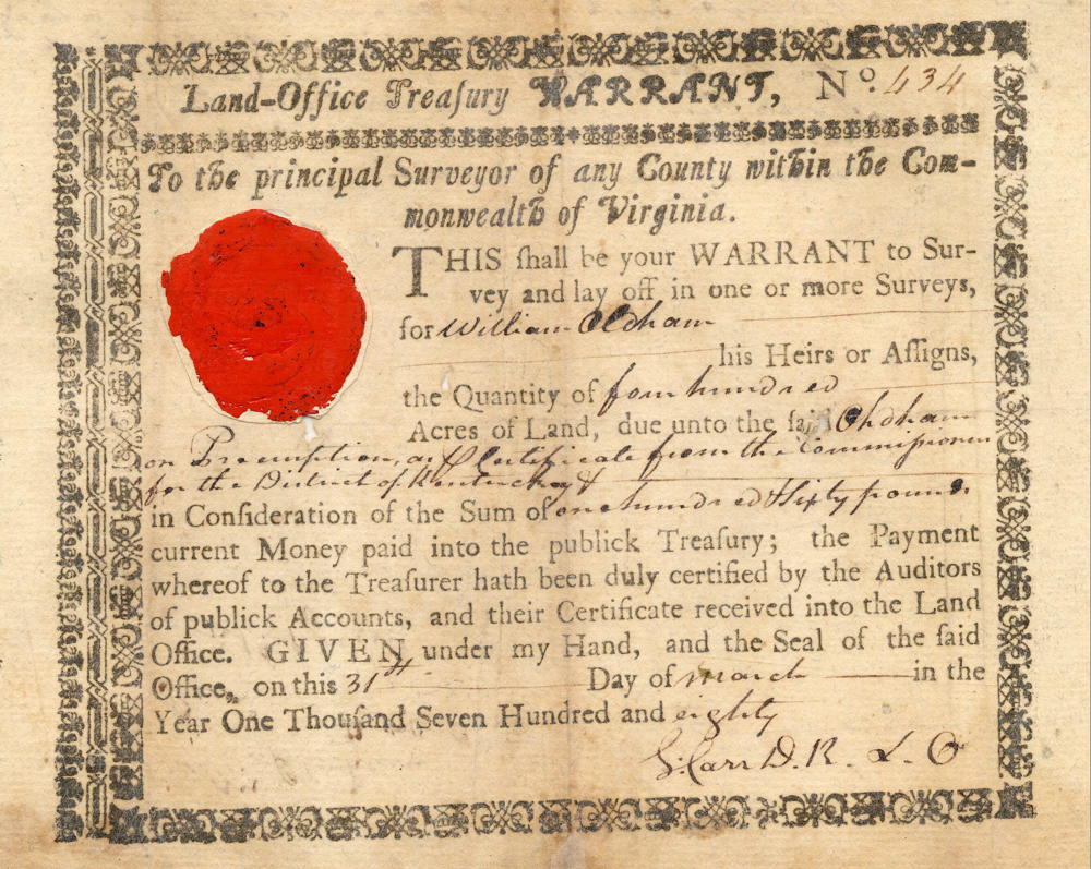
Warrant
Survey
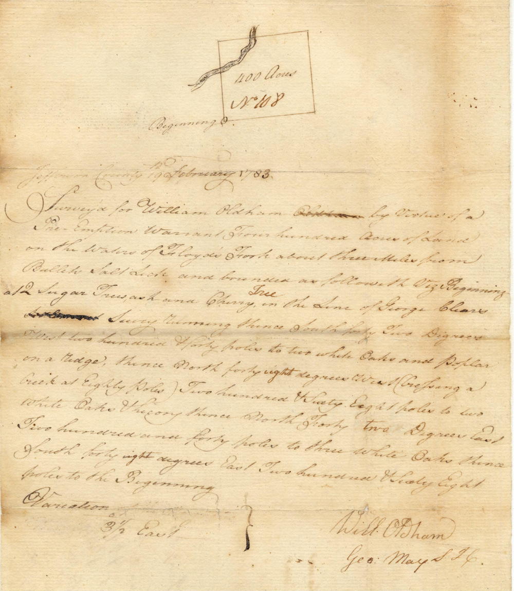
Jefferson County, 19 February 1783
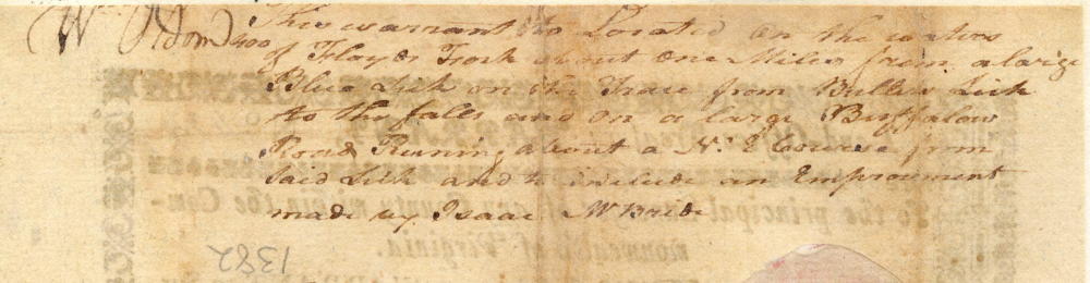
Surveyed for William Oldham by virtue of a preemption warrant four hundred acres of land on the waters of Floyd's Fork about three miles from Bullitt's Salt Lick and bounded as followeth viz. Beginning at 2 sugar trees, ash and cherry tree in the line of George Clear's survey running thence South forty two degrees West two hundred & forty poles to two white oaks and poplar on a ridge, thence North forty eight degrees West (crossing a creek at eighty poles) two hundred & sixty eight poles to two white oaks & hickory, thence North forty two degrees East two hundred and forty poles to three white oaks, thence South forty eight degrees East two hundred & sixty eight poles to the beginning. Will Oldham, Surveyor
Deed
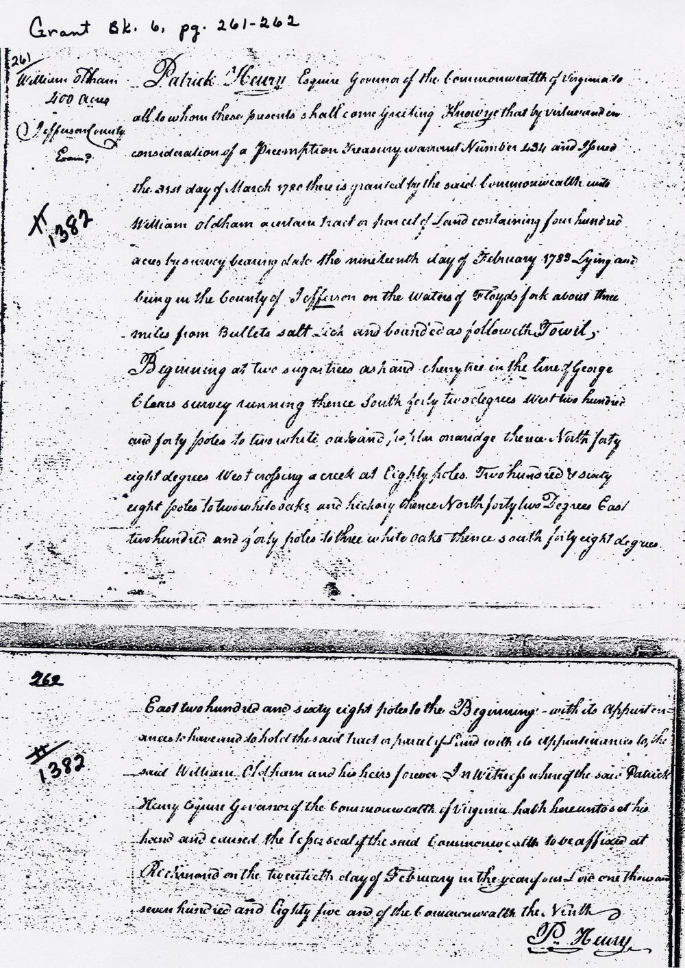
Virginia Grant Book 6, pages 261-262
Patrick Henry Esquire, Governor of the Commonwealth of Virginia, to all to whom these presents shall come, greeting. Know ye that by virtue and in consideration of a preemption treasury warrant Number 434 and issued the 31st day of March 1780, there is granted by the said Commonwealth unto William Oldham a certain tract or parcel of land containing four hundred acres by survey bearing date the nineteenth day of February 1783, lying and being in the county of Jefferson on the waters of Floyd's Fork about three miles from Bullitt's Salt Lick and bounded as followeth, to wit. Beginning at two sugar trees, ash and cherry tree in the line of George Clear's survey, running thence South forty two degrees West two hundred and forty poles to two white oaks and poplar on a ridge, thence North forty eight degrees West, crossing a creek at eighty poles, two hundred & sixty eight poles to two white oaks and hickory, thence North forty two degrees East two hundred and forty poles to three white oaks, thence South forty eight degrees East two hundred and sixty eight poles to the beginning, with its appurtenances to have and to hold the said tract or parcel of land with its appurtenances to the said William Oldham and his heirs forever. In witness whereof the said Patrick Henry Esquire, Governor of the Commonwealth of Virginia, hath hereunto set his hand and caused the lesser seal of the said Commonwealth to be affixed at Richmond on the twentieth day of February in the year of our Lord one thousand seven hundred and eighty five, and of the Commonwealth the ninth. (signed) P. Henry
If you, the reader, have an interest in any particular part of our county history, and wish to contribute to this effort, use the form on our Contact Us page to send us your comments about this, or any Bullitt County History page. We welcome your comments and suggestions. If you feel that we have misspoken at any point, please feel free to point this out to us.
The Bullitt County History Museum, a service of the Bullitt County Genealogical Society, is located in the county courthouse at 300 South Buckman Street (Highway 61) in Shepherdsville, Kentucky. The museum, along with its research room, is open 10 a.m. to 4 p.m. Monday through Friday. Saturday appointments are available by calling 502-921-0161 during our regular weekday hours. Admission is free. The museum, as part of the Bullitt County Genealogical Society, is a 501(c)3 tax exempt organization and is classified as a 509(a)2 public charity. Contributions and bequests are deductible under section 2055, 2106, or 2522 of the Internal Revenue Code. Page last modified: 12 Jan 2024 . Page URL: bullittcountyhistory.org/bchistory/william-oldham400.html