
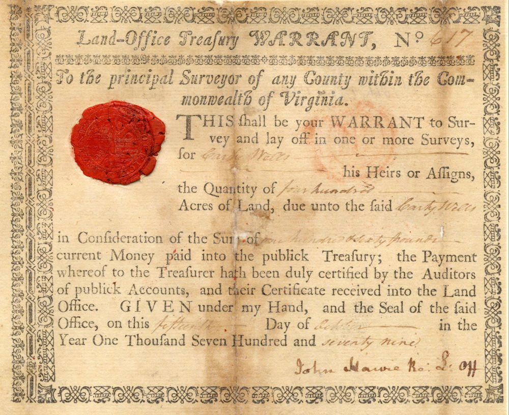
On 23 Dec 1782, John Ray surveyed 400 acres for Carty Wells, located beside the road leading from Bullitt's Lick to the Falls of the Ohio. This tract is later referenced as adjoining that of George Slaughter's 680 acre tract. Wells received a deed to his land on 4 Jan 1786. Then, on 14 Apr 1810, Wells, who was living in Shelby County, sold his claim to this land to Abraham Miller who also lived in Shelby County at the time. Then, on 18 Aug 1810, Miller sold the tract to Joseph Brooks.
Survey
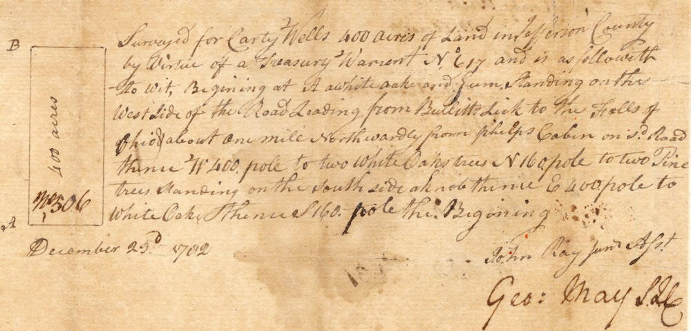
Surveyed for Carty Wells 400 acres of land in Jefferson County by virtue of a treasury warrant No. 617 and is as followeth, to wit. Beginning at A a white oak and gum standing on the west side of the road leading from Bullitt's Lick to the Falls of Ohio & about one mile northwardly from Phelps' cabin on said road, thence W 400 poles to two white oak trees, N 160 poles to two pine trees standing on the south side a knob, thence E 400 poles to white oak, thence S 160 poles to the beginning. December 23rd 1782. John Ray, surveyor.
Deed
Virginia Grant Book 7, page 410
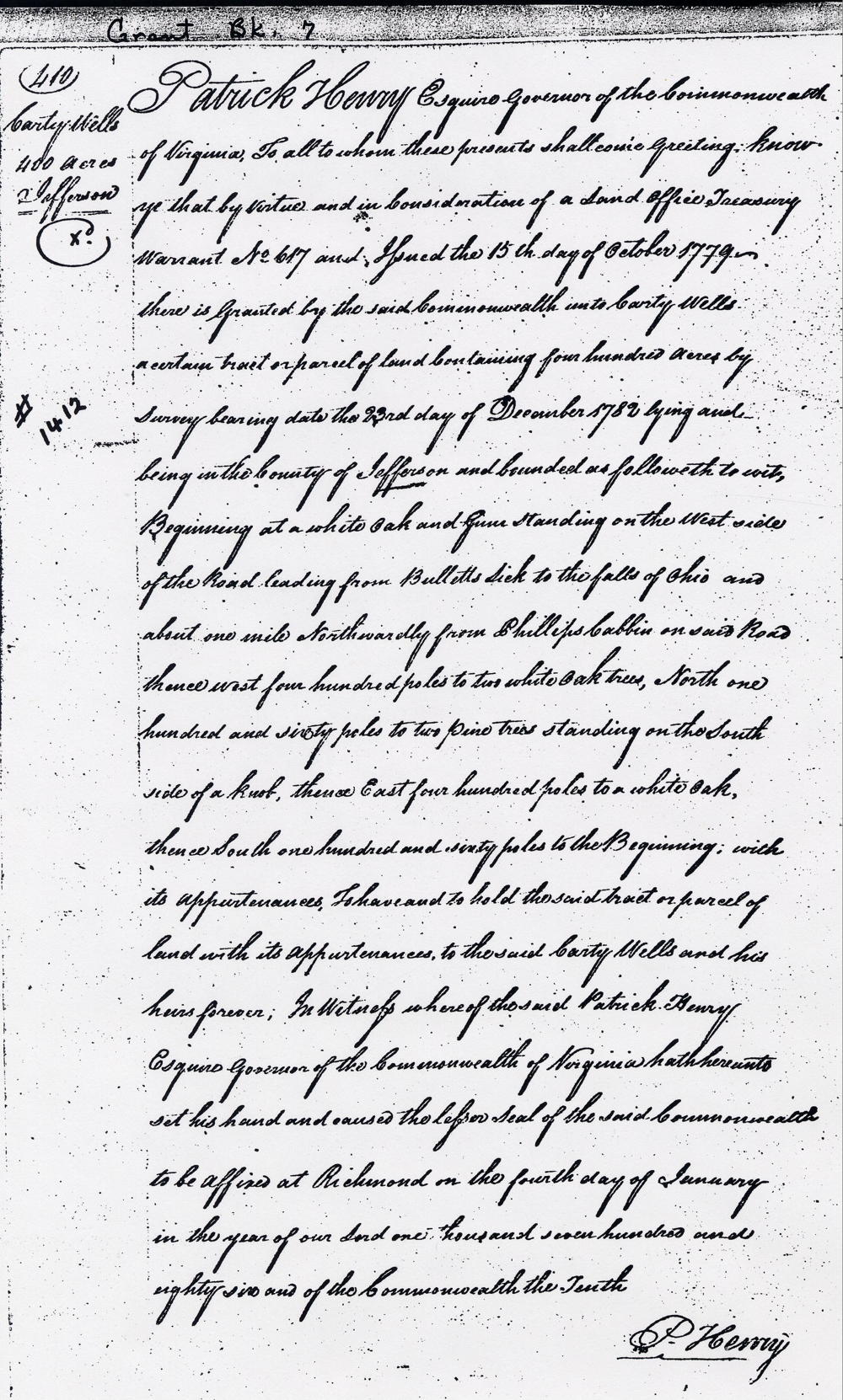
Patrick Henry Esquire, governor of the Commonwealth of Virginia, to all to whom these presents shall come, greeting. Knoq ye that by virtue and in consideration of a land office treasury warrant number 617 and issued the 15th day of October 1779, there is granted by the said Commonwealth unto Carty Wells a certain tract or parcel of land containing 400 acres by survey bearing date the 23rd day of December 1782, lying and being in the county of Jefferson and bounded as followeth, to wit. Beginning at a white oak and gum standing on the west side of the road leading from Bullitt's Lick to the Falls of Ohio and about one mile northwardly from Phillips' cabin on said road, thence West 400 poles to two white oak trees, North 160 poles to two pine trees standing on the south side a knob, thence East 400 poles to white oak, thence South 160 poles to the beginning with its appurtenances, to have and to hold the said tract or parcel of land with its appurtenances to the said Carty Wells and his heirs forever. In witness where of the said Patrick Henry Esquire, governor of the Commonwealth of Virginia, hath hereunto set his hand and caused the lesser seal of the said Commonwealth to be affixed at Richmond on the fourth day of January in the year of our Lord 1786, and of the Commonwealth the tenth. (signed) P. Henry
Warrant
If you, the reader, have an interest in any particular part of our county history, and wish to contribute to this effort, use the form on our Contact Us page to send us your comments about this, or any Bullitt County History page. We welcome your comments and suggestions. If you feel that we have misspoken at any point, please feel free to point this out to us.
The Bullitt County History Museum, a service of the Bullitt County Genealogical Society, is located in the county courthouse at 300 South Buckman Street (Highway 61) in Shepherdsville, Kentucky. The museum, along with its research room, is open 10 a.m. to 4 p.m. Monday through Friday. Saturday appointments are available by calling 502-921-0161 during our regular weekday hours. Admission is free. The museum, as part of the Bullitt County Genealogical Society, is a 501(c)3 tax exempt organization and is classified as a 509(a)2 public charity. Contributions and bequests are deductible under section 2055, 2106, or 2522 of the Internal Revenue Code. Page last modified: 12 Sep 2024 . Page URL: bullittcountyhistory.org/bchistory/1412-wells.html