
On 24 Jun 1784, Thomas Whitledge surveyed 200 acres of land for Brooke Beall located about 200 poles east of Brook's Spring. Brooke Beall then signed the tract over to Walter Beall on 9 Jan 1785, and Walter obtained a deed for the land on 20 Sep 1787. This was #15 on the 1811 plat drawing by James Shanks, Bullitt County Surveyor, which is described on another page.
Survey
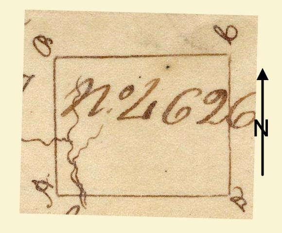
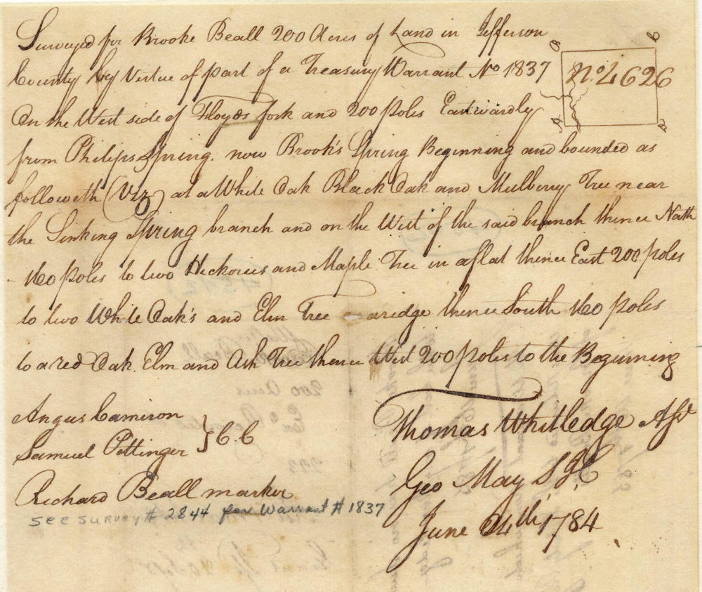
Surveyed for Brooke Beall 200 acres of land in Jefferson County by virtue of part of a treasury warrant No. 1837 on the west side of Floyds fork and 200 poles eastwardly from Philips Spring, now Brooks' Spring, beginning and bounded as followeth (viz) at a white oak, black oak and mulberry tree near the Sinking Spring branch and on the west of the said branch, thence North 160 poles to two hickories and maple tree in a flat, thence East 200 poles to two white oaks and elm tree on a ridge, thence South 160 poles to a red oak, elm and ash tree, thence West 200 poles to the beginning. Thomas Whitledge, surveyor. June 24th 1784. Angus Cameron & Samuel Pottinger, chain carriers. Richard Beall, marker.
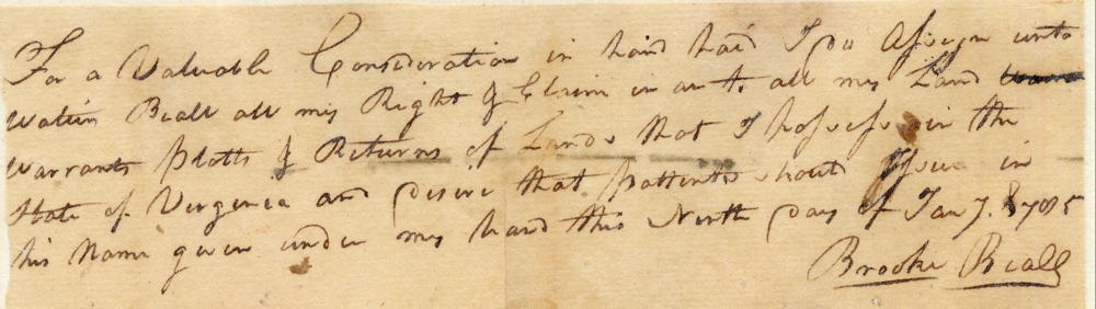
For a valuable consideration in hand paid, I assign unto Walter Beall all my right & claim in and to all my land warrants, platts & returns of land that I possess in the state of Virginia and desire that patents ... issued in his name. Given under my hand this 9th day of Jany 1785. (signed) Brooke Beall
Deed
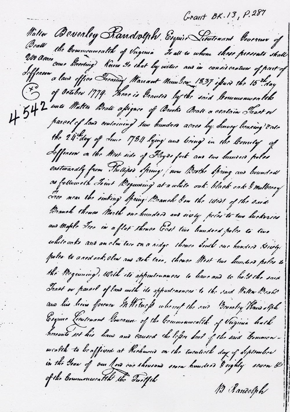
Virginia Grant Book 13, page 287
Beverly Randolph Esquire, Lieutenant Governor of the Commonwealth of Virginia, to all to whom these presents shall come, greeting. Know ye that by virtue and in consideration of part of a land office treasury warrant number 1837, issued the 15th day of October 1779, there is granted by the said Commonwealth unto Walter Beall, assignee of Brooke Beall, a certain tract or parcel of land containing 200 acres by survey bearing date the 24th day of June 1784, lying and being in the County of Jefferson on the west side of Floyd's fork and 200 poles eastwardly from Philips Spring, (now Brooks' Spring) and bounded as followeth (viz) Beginning at a white oak, black oak and mulberry tree near the Sinking Spring branch and on the west of the said branch, thence North 160 poles to two hickories and maple tree in a flat, thence East 200 poles to two white oaks and elm tree on a ridge, thence South 160 poles to a red oak, elm and ash tree, thence West 200 poles to the beginning with its appurtenances to have and to hold the said tract or parcel of land with its appurtenances to the said Walter Beall and his heirs forever. In witness whereof the said Beverly Randolph Esquire, Lieutenant Governor of the Commonwealth of Virginia, hath hereunto set his han and caused the lesser seal of the said Commonwealth to be affixed at Richmond on the 20th day of September in the year of our Lord 1787, & the Commonwealth the 12th. (signed) B. Randolph
If you, the reader, have an interest in any particular part of our county history, and wish to contribute to this effort, use the form on our Contact Us page to send us your comments about this, or any Bullitt County History page. We welcome your comments and suggestions. If you feel that we have misspoken at any point, please feel free to point this out to us.
The Bullitt County History Museum, a service of the Bullitt County Genealogical Society, is located in the county courthouse at 300 South Buckman Street (Highway 61) in Shepherdsville, Kentucky. The museum, along with its research room, is open 10 a.m. to 4 p.m. Monday through Friday. Saturday appointments are available by calling 502-921-0161 during our regular weekday hours. Admission is free. The museum, as part of the Bullitt County Genealogical Society, is a 501(c)3 tax exempt organization and is classified as a 509(a)2 public charity. Contributions and bequests are deductible under section 2055, 2106, or 2522 of the Internal Revenue Code. Page last modified: 12 Sep 2024 . Page URL: bullittcountyhistory.org/bchistory/4542-beall.html