
Isaac Cox surveyed this 200 acre tract on the south side of Salt River, about 300 poles downstream from Cox's Creek, for Henry Wilson on 17 Mar 1784, who received the deed for it on 10 Aug 1786.
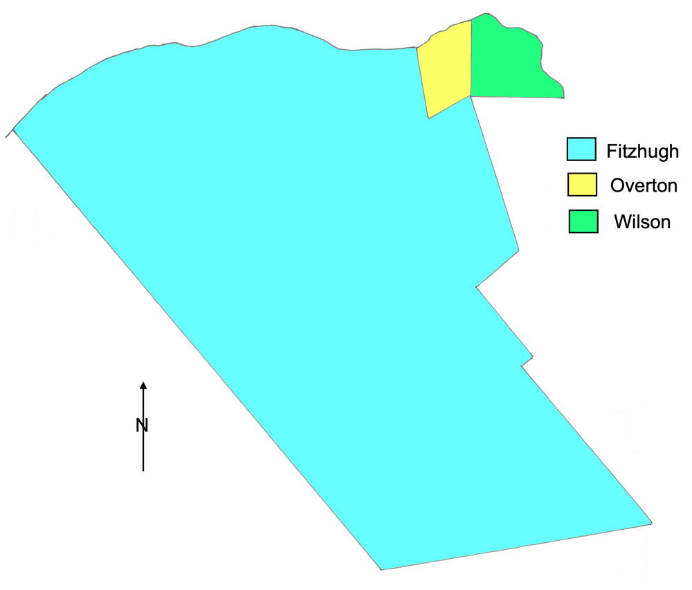
The drawing to the right shows Wilson's tract in relation to the next two downstream, that of Clough & William Overton, and the large tract patented to William Fitzhugh. Salt River forms the northern border of these three tracts, and is roughly drawn in on this drawing.
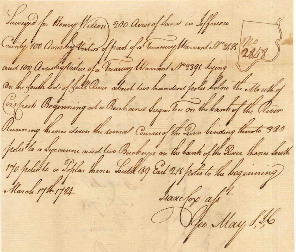
Survey
Surveyed for Henry Wilson 200 acres of land in Jefferson County, 100 acres by virtue of part of a treasury warrant number 2485 and 100 acres by virtue of a treasury warrant number 2391 lying on the south side of Salt River about 200 poles below the mouth of Cox's Creek. Beginning at a beech and sugar tree on the bank of the river, running thence dow the several courses of the river binding thereto 380 poles to a sycamore and two buckeyes on the bank of the river, thence South 170 poles to a poplar, thence South 89 East 215 poles to the beginning. March 17th, 1784. Isaac Cox, surveyor.
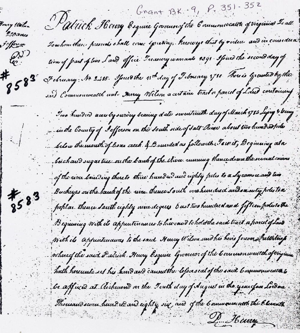
Deed
Virginia Grant Book 9, pages 351-352
Patrick Henry Esquire, Governor of the Commonwealth of Virginia, to all to whom these presents shall come, greeting. Know ye that by virtue of and in consideration of two land office treasury warrant numbers 2391 issue the second day of February; No. 2485 issue the 15th day of February 1780, there is granted by the said Commonwealth unto the said Henry Wilson a certain tract or parcel of land containing 200 acres by survey bearing date the 17th day of March 1784, lying and being in the county of Jefferson on the south side of Salt River about 200 poles below the mouth of Cox's Creek and bounded as followeth, to wit. Beginning at a beech and sugar tree on the bank of the river, running thence down the several courses of the river binding thereto 380 poles to a sycamore and two buckeyes on the bank of the river, thence South 170 poles to a poplar, thence South 89 East 215 poles to the beginning with its appurtenances to have and to hold the said tract or parcel of land with its appurtenances to the said Henry Wilson & his heirs forever. In witness whereof the said Patrick Henry Esquire, Governor of the Commonwealth of Virginia, hath hereunto set his hand and caused the lesser seal of the said Commonwealth to be affixed at Richmond on the tenth day of August in the year of our Lord one thousand seven hundred and eighty six & of the Commonwealth the eleventh. (signed) Patrick Henry
If you, the reader, have an interest in any particular part of our county history, and wish to contribute to this effort, use the form on our Contact Us page to send us your comments about this, or any Bullitt County History page. We welcome your comments and suggestions. If you feel that we have misspoken at any point, please feel free to point this out to us.
The Bullitt County History Museum, a service of the Bullitt County Genealogical Society, is located in the county courthouse at 300 South Buckman Street (Highway 61) in Shepherdsville, Kentucky. The museum, along with its research room, is open 10 a.m. to 4 p.m. Monday through Friday. Saturday appointments are available by calling 502-921-0161 during our regular weekday hours. Admission is free. The museum, as part of the Bullitt County Genealogical Society, is a 501(c)3 tax exempt organization and is classified as a 509(a)2 public charity. Contributions and bequests are deductible under section 2055, 2106, or 2522 of the Internal Revenue Code. Page last modified: 12 Sep 2024 . Page URL: bullittcountyhistory.org/bchistory/8583henrywilson.html