
John Edwards sold his settlement of 400 acres and preemption of 1000 acres on the south side of Salt River to Patrick McGee in June 1789. The deed was recorded in Nelson County as the south side of Salt River was in that county at the time. A transcription of the deed is provided below, followed by an image of it. Note that the deed's description of the metes and bounds contain errors when compared to the original settlement and preemption documents. Additions are added in red print and in brackets; deletions are stricken out. Also, a plat drawing showing the relationships of the three tracts is shown. Inserted in the transcription are capital letters in brackets that refer to locations marked on the plat drawing.
Patrick McGee later sold different parts of these tracts to Ben Pope Sr. in 1786, Richard Simmons in 1790, Jacob Ambrose in 1805, and Michael Troutman in 1800. The Pope tract deed was finalized in 1800 to Ben Pope Jr.
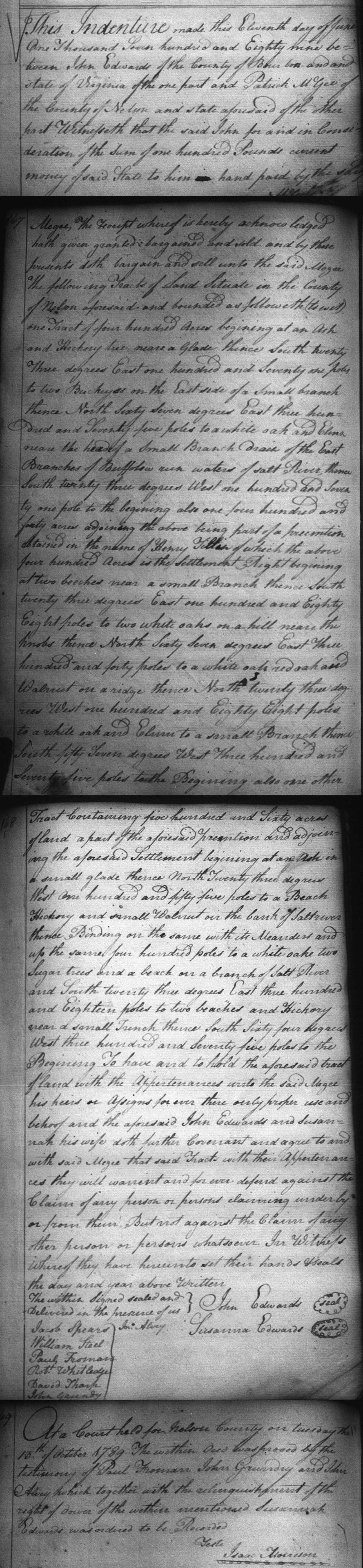
Nelson County Deed Book 2, pages 166-168
John & Susannah Edwards to Patrick McGee
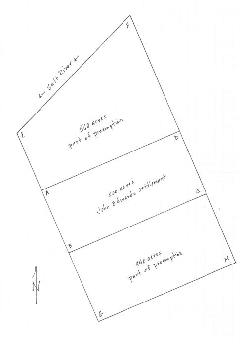
This indenture made this eleventh day of June, one thousand seven hundred and eighty nine between John Edwards of the county of Bourbon and state of Virginia of the one part and Patrick McGee of the county of Nelson and state aforesaid of the other part. Witnesseth that the said John for and in consideration of the sum of one hundred pounds current money of said state to him in hand paid by the said McGee, the receipt whereof is hereby acknowledged, hath given, granted, bargained and sold, and by these presents doth bargain and sell unto the said McGee the following tracts of land situate in the county of Nelson aforesaid and bounded as followeth (to wit). One tract of four hundred acres beginning at [A] an ash and hickory tree near a glade, thence South twenty three degrees East one hundred and seventy one poles to [B] two buckeyes on the East side of a small branch, thence North sixty seven degrees East three hundred and seventy five poles to [C] a white oak and elm near the head of a small branch drain of the East Branch of Buffalo Run waters of Salt River, [North twenty three degrees West one hundred and seventy one poles to [D] two beeches and hickory, thence South sixty seven degrees West three hundred and seventy five poles] thence South twenty three degrees West one hundred and seventy one poles to the beginning; also one four hundred and forty acres adjoining the above, begin part of a preemption obtained in the name of Henry Tillin of which the above four hundred acres is the settlement right, beginning at [B] two beeches near a small branch, thence South twenty three degrees East one hundred and eighty eight poles to [G] two white oaks on a hill near the knobs, thence North sixty seven degrees East three hundred and [seventy five] forty poles to [H] a while oak, red oak and walnut on a ridge, thence North twenty three degrees West one hundred and eighty eight poles to [C] a white oak and elm to a small branch, thence South [sixty] fifty seven degrees West three hundred and seventy five poles to the beginning; also one other tract containing five hundred and sixty acres of land a part of the aforesaid preemption and adjoining the aforesaid settlement, beginning at an [A] oak in a small glade, thence North twenty three degrees West one hundred and fifty five poles to [E] a beech, hickory and small walnut on the bank of Salt River, thence binding on the same with its meanders and up the same four hundred poles to [F] a white oak, two sugar trees and a beech on a bank of Salt River and South twenty three degrees East three hundred and eighteen poles to [D] two beeches and hickory near a small branch, thence South sixty [seven] four degrees West three hundred and seventy five poles to the beginning. To have and to hold the aforesaid tract of land with the appurtenances unto the said McGee, his heirs or assigns forever their olny proper use and behoof and the aforesaid John Edwards and Susannah his wife doth further covenant and agree to and with said McGee that said tract with their appurtenances they will warrant and forever defend against the claim of any person or persons claiming under by or from them, but not against the claim of any other person or persons whatsoever. In witness whereof they have hereunto set their hands & seals the day and year above written. (signed) John Edwards, Susanna Edwards
The within signed, sealed and delivered in the presence of us. (signed) Jacob Spears, William Steel, Paul Froman, Robert Whitledge, David Tharp, John Grundy, John Alvey
At a court held for Nelson County on Tuesday the 13th of October 1789, the within deed was proved by the testimony of Paul Froman, John Grundy and John Alvey which, together with the acknowledgement of the right of dower of the within mentioned Susannah Edwards was ordered to be recorded. Teste. Isaac Morrison
If you, the reader, have an interest in any particular part of our county history, and wish to contribute to this effort, use the form on our Contact Us page to send us your comments about this, or any Bullitt County History page. We welcome your comments and suggestions. If you feel that we have misspoken at any point, please feel free to point this out to us.
The Bullitt County History Museum, a service of the Bullitt County Genealogical Society, is located in the county courthouse at 300 South Buckman Street (Highway 61) in Shepherdsville, Kentucky. The museum, along with its research room, is open 10 a.m. to 4 p.m. Monday through Friday. Saturday appointments are available by calling 502-921-0161 during our regular weekday hours. Admission is free. The museum, as part of the Bullitt County Genealogical Society, is a 501(c)3 tax exempt organization and is classified as a 509(a)2 public charity. Contributions and bequests are deductible under section 2055, 2106, or 2522 of the Internal Revenue Code. Page last modified: 12 Sep 2024 . Page URL: bullittcountyhistory.org/bchistory/edwards-mcgee.html