
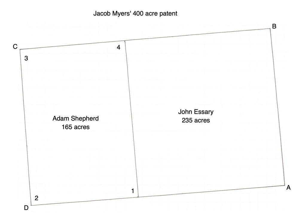
Isaac Cox surveyed a 400 acre tract for Jacob Myers on 24 Oct 1783 on Long Lick Creek. A deed to the tract was issued on 2 Dec 1785. Both survey and deed are shown below, together with their transcriptions. We believe this may be a tract described in a land dispute here and here. The drawing shown here of this tract shows how it was later sold to Adam Shepherd and John Essary.
Survey
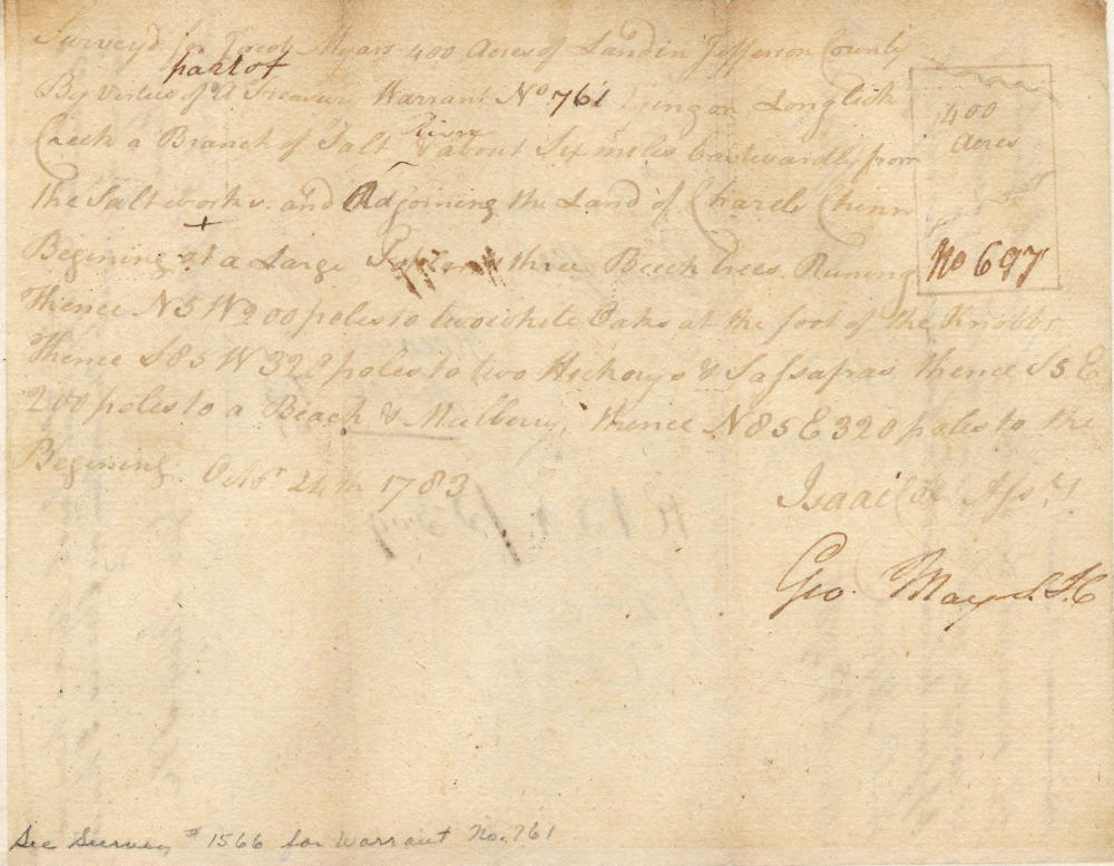
Surveyed for Jacob Myers 400 acres of land in Jefferson County by virtue of a treasury warrant No. 761 lying on Long Lick Creek, a branch of Salt River about six miles eastward from the salt works and adjoining the land of Charles Chinn. Beginning at [A] a large poplar and three beech trees running thence N 5 W 200 poles to [B] two white oaks at the foot of the knobs, thence S 85 W 320 poles to [C] two hickorys & sassafras, thence S 5 E 200 poles to [D] a beech & mulberry, thence N 85 E 320 poles to the beginning. Oct 24th 1783. Isaac Cox, Assistant Surveyor
Court Case Plat Drawing Rotated
Marked 11, 12, 13, 14 as boundary.
Deed
Virginia Grant Book 4, pp. 445-6
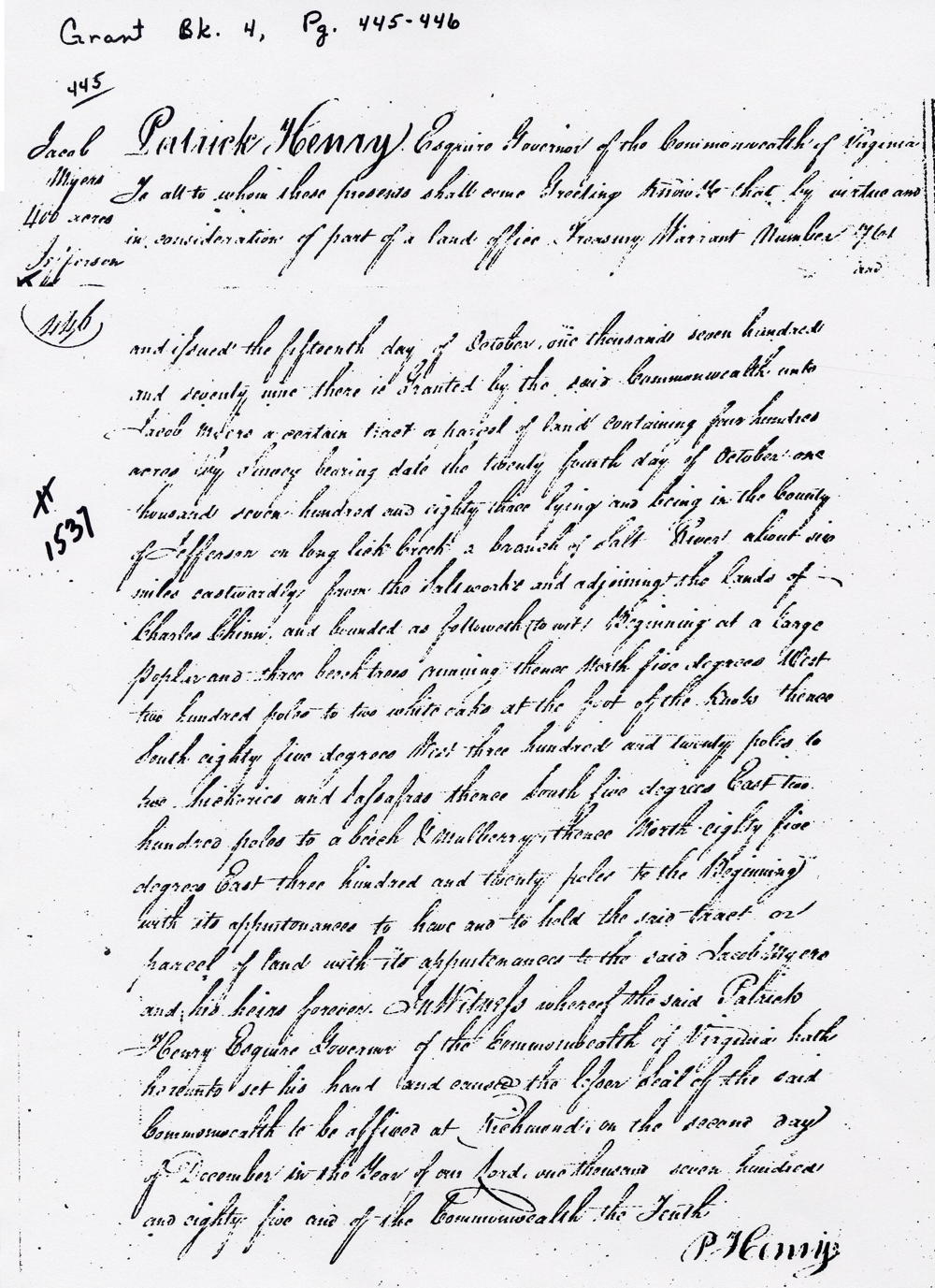
Patrick Henry Esquire, Governor of the Commonwealth of Virginia, to all to whom these presents shall come, greeting. Know ye that by virtue and in consideration of part of a land office treasury warrant number 761 and issued the fifteenth day of October one thousand seven hundred and seventy nine there is granted by the said Commonwealth unto Jacob Myers a certain tract or parcel of land containing four hundred acres by survey bearing date the twenty fourth day of October one thousand seven hundred and eighty three lying and being in the County of Jefferson on Long Lick Creek a branch of Salt River about six miles eastwardly from the saltworks and adjoining the lands of Charles Chinn, and bounded as followeth, to wit. Beginning at a large poplar and three beech trees, running thence North five degrees West two hundred poles to two white oaks at the foot of the knobs, thence South eighty five degrees West three hundred and twenty poles to two hickories and sassafras, thence South five degrees East two hundred poles to a beech & mulberry, thence North eighty five degrees East three hundred and twenty poles to the beginning with its appurtenances to have and to hold the said tract or parcel of land with its appurtenances to the said Jacob Myers and his heirs forever. In witness whereof the said Patrick Henry Esquire, Governor of the Commonwealth of Virginia hath hereunto set his hand and caused the lesser seal of the said Commonwealth to be affixed at Richmond on the second day of December in the year of our Lord one thousand seven hundred and eighty five and of the Commonwealth the tenth. (signed) P. Henry
If you, the reader, have an interest in any particular part of our county history, and wish to contribute to this effort, use the form on our Contact Us page to send us your comments about this, or any Bullitt County History page. We welcome your comments and suggestions. If you feel that we have misspoken at any point, please feel free to point this out to us.
The Bullitt County History Museum, a service of the Bullitt County Genealogical Society, is located in the county courthouse at 300 South Buckman Street (Highway 61) in Shepherdsville, Kentucky. The museum, along with its research room, is open 10 a.m. to 4 p.m. Monday through Friday. Saturday appointments are available by calling 502-921-0161 during our regular weekday hours. Admission is free. The museum, as part of the Bullitt County Genealogical Society, is a 501(c)3 tax exempt organization and is classified as a 509(a)2 public charity. Contributions and bequests are deductible under section 2055, 2106, or 2522 of the Internal Revenue Code. Page last modified: 12 Sep 2024 . Page URL: bullittcountyhistory.org/bchistory/jacob-myer400.html