
I. Hite surveyed three tracts for Jacob Myers on 6 Aug 1783 on the waters of Floyd's Fork. The first was for 50 acres in which he was careful to include the site of Clear's Station. Then he surveyed one for 400 acres adjoining the first tract to the south and west, and a second of 500 acres to the north. Later, in 1795, Myers sold all three tracts to Joseph Brooks, as described on another page.
50 Acre and 400 Acre Surveys
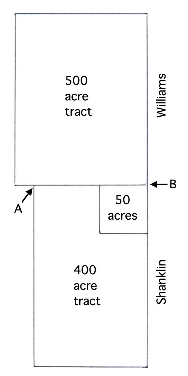
Surveyed for Jacob Myers 50 acres of land in Jefferson County by virtue of a military warrant on the west side of the road from the salt works to the Falls and about 4 miles from the salt works including Clear's Station. Beginning at [B] a large poplar and black oak corner to Edward Williams and Robert Shanklin and running with Shanklin's line S 89 1/2 poles to a red oak & sugar tree. Then West 89 1/2 poles to a beech, then North 89 1/2 poles to a sugar tree & ash, then East 89 1/2 poles to the beginning. Also, 400 acres by virtue of part of a treasury warrant No. 761 lying on the water of Floyd's Fork joining survey of 50 acres on the south and west, Beginning at [A] a white gum and elm standing by a branch in the knobs west of Clear Station and running East 122 1/2 poles to sugar tree & ash at NW corner to his 50 acre survey, then with the lines thereof S 89 1/2 poles to a beech, then East 89 1/2 poles to a red oak & sugar tree in Robt Shanklin's line, then with said line South 250 1/2 poles to a red oak, sugar tree, & beech, then West 212 poles to a sweet gum and beech, then North 340 poles to the Beginning. Aug 6th 1783. J. Hite, assistant surveyor

50 Acre Deed
Virginia Grant Book 3, pp 154-5
Patrick Henry Esquire, Governor of the Commonwealth of Virginia, to all to whom these presents shall come, greeting. Know ye that by virtue of part of a military warrant there is granted by the said Commonwealth unto Jacob Myers a certain tract or parcel of land containing fifty acres, by survey bearing date the 6th day of August 1783, lying and being in the county of Jefferson on the west side of the road from the salt works to the Falls and about four miles from the salt works, including Clears Station, and bounded as followeth, to wit. Beginning at a large poplar and black oak, corner to Edward Williams and Robert Shanklin, and running with Shanklin's line South eighty nine and a half poles to a red oak and sugar tree, thence West eighty nine and a half poles to a beech, thence North eighty nine and a half poles to a sugar tree and ash, thence East eighty nine and a half poles to the Beginning with its appurtenances to the said Jacob Myers and his heirs forever. In witness whereof the said Patrick Henry Esquire, Governor of the Commonwealth of Virginia, hath hereunto set his hand and caused the lesser seal of the said Commonwealth to be affixed at Richmond on the nineteenth day of May in the year of our Lord one thousand seven hundred and eighty five, and of the Commonwealth the ninth. (signed) Patrick Henry

400 Acre Deed
Virginia Grant Book 4, pp 440-1
Patrick Henry Esquire, Governor of the Commonwealth of Virginia, to all to whom these presents shall come, greeting. Know ye that by virtue of part of a land office treasury warrant number 761 and issued the fifteenth day of October, one thousand seven hundred and seventy nine there is granted by the said Commonwealth unto Jacob Myers a certain tract or parcel of land containing four hundred acres by survey bearing date the sixth day of August one thousand seven hundred and eighty three, lying and being in the county of Jefferson on the waters of Floyd's Fork, adjoining his survey of fifty acres on the south and west and bounded as followeth (to wit) Beginning at a white gum and elm standing by a branch in the knobs west of Clears Station and running East 122 1/2 poles to sugar tree & ash north west corner to his 50 acre survey, then with the lines thereof S 89 1/2 poles to a beech, then East 89 1/2 poles to a red oak & sugar tree in Robert Shanklin's line, thence with said line South 250 1/2 poles to a red oak, sugar & beech, thence West 212 poles to a sweet gum and beech, thence North 340 poles to the Beginning with its appurtenances to have and to hold the said tract or parcel of land with its appurtenances to the said Jacob Myers and his heirs forever. In witness whereof the said Patrick Henry Esquire, Governor of the Commonwealth of Virginia, hath hereunto set his hand and caused the lesser seal of the said Commonwealth to be affixed at Richmond on the second day of December in the year of our Lord one thousand seven hundred and eighty five, and of the Commonwealth the ninth. (signed) Patrick Henry

500 Acre Survey
Surveyed for Jacob Myers 500 acres of land in Jefferson County by virtue of a treasury warrant lying on the waters of Floyd's Fork about 4 miles from the salt works, joining Maj. Beasley on the south, Edward Williams on the west, and his survey of 450 acres on the north, Beginning at a white oak, gum & elm standing by a branch NW corner to his survey of 400 acres and running from thence with the line of said survey and the line of his 50 acre survey East 212 poles to a large poplar & black oak corner to Robt. Shanklin & Edward Williams, thence with Williams' line North 324 poles to a white oak, elm and beech in Major Beasley's line, then with his line West 246 3/4 poles to a white oak, then South 324 poles to a white oak, then East 34 3/4 poles to the beginning. Aug 6th 1783. J. Hite, assistant surveyor

500 Acre Deed
Virginia Grant Book 4, p. 447
Patrick Henry Esquire, Governor of the Commonwealth of Virginia, to all to whom these presents shall come, greeting. Know ye that by virtue and in consideration of pat of two land office treasury warrants No. 4866 and issued the ninth day of May one thousand seven hundred and eighty, and number 6137 and issued the eighteenth day of September one thousand seven hundred and eighty one there is granted by the said Commonwealth unto Jacob Myers a certain tract or parcel of land containing five hundred acres by survey bearing date the sixth day of August one thousand seven hundred and eighty three lying and being in the County of Jefferson on the waters of Floyd's Fork about four miles from the salt works, joining Major Beasley on the south, Edward Williams on the west, and his survey of four hundred and fifty acres on the north and bounded as followeth, to wit. Beginning at a white oak, gum and elm standing by a branch northwest corner to his survey of four hundred acres and running from thence with the line of said survey and the line of his fifty acre survey East two hundred and twelve poles to a large poplar and black oak corner to Robert Shanklin and Edward Williams, thence with William's line north three hundred and twenty four poles to a white oak, elm and beech in Major Beasley's line, then with his line West two hundred forty six & three-quarter poles to a white oak, then South three hundred and twenty four poles to a white oak, then East thirty four and three-quarter poles to the Beginning with its appurtenances to have and to hold the said tract or parcel of land with its appurtenances to the said Jacob Myers and his heirs forever. In witness whereof the said Patrick Henry Esquire, Governor of the Commonwealth of Virginia, hath hereunto set his hand and caused the lesser seal of the said Commonwealth to be affixed at Richmond on the second day of December in the year of our Lord one thousand seven hundred and eighty five & of the Commonwealth the tenth. (signed) P. Henry

If you, the reader, have an interest in any particular part of our county history, and wish to contribute to this effort, use the form on our Contact Us page to send us your comments about this, or any Bullitt County History page. We welcome your comments and suggestions. If you feel that we have misspoken at any point, please feel free to point this out to us.
The Bullitt County History Museum, a service of the Bullitt County Genealogical Society, is located in the county courthouse at 300 South Buckman Street (Highway 61) in Shepherdsville, Kentucky. The museum, along with its research room, is open 10 a.m. to 4 p.m. Monday through Friday. Saturday appointments are available by calling 502-921-0161 during our regular weekday hours. Admission is free. The museum, as part of the Bullitt County Genealogical Society, is a 501(c)3 tax exempt organization and is classified as a 509(a)2 public charity. Contributions and bequests are deductible under section 2055, 2106, or 2522 of the Internal Revenue Code. Page last modified: 12 Sep 2024 . Page URL: bullittcountyhistory.org/bchistory/jacob-myer950.html