
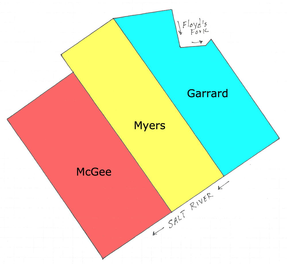
Jacob Myer patented the 400 acre tract where Dowdall's Station stood across from Pope's Cabin. His tract lay between those of James Garrard to the east, and Thomas McGee to the west, as shown in this drawing.
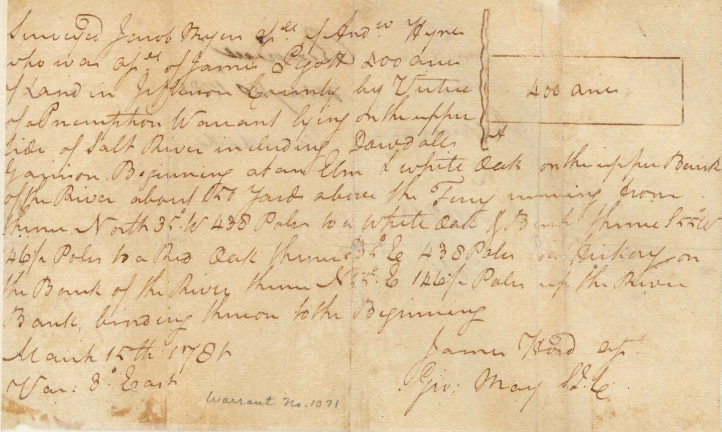
Below is a digital image of the original plat and description drawn by James Hord. It and the following patent are provided by the Kentucky Secretary of State's web site.
Survey
Note that this plat was drawn facing west instead of north, so Myer's land was on the north side of Salt River.
Although Hord completed the survey in 1781, it was not until 1782 that Myer's patent was granted. A digital image of that patent, as written in Grant Book 1, pages 331-332, is shown below.
Deed
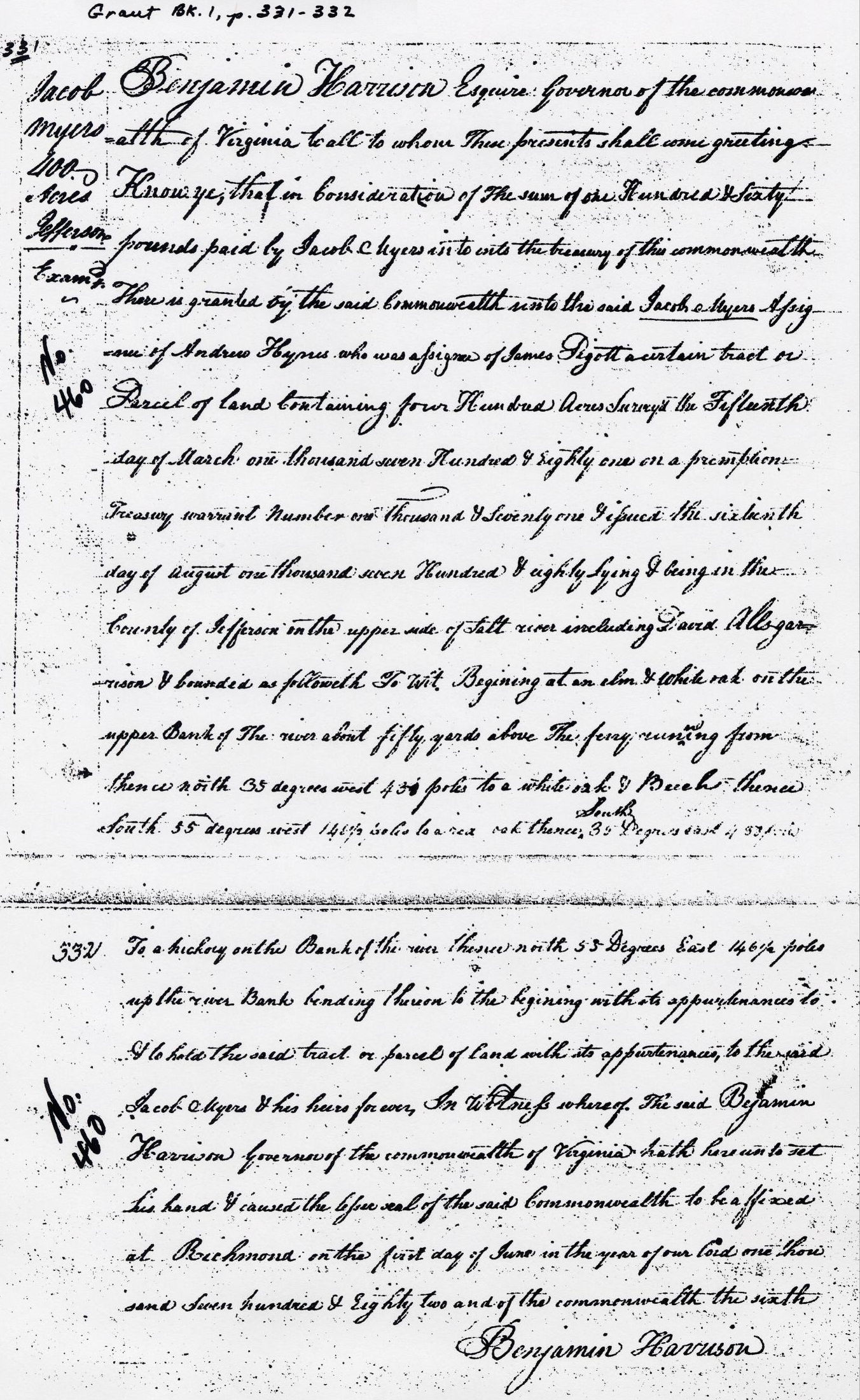
Grant Bk 1, p. 331-332
Jacob Myers 400 Acres in Jefferson County
Benjamin Harrison Esquire Governor of the Commonwealth of Virginia to all to whom these presents shall come greeting. Know ye that in consideration of the sum of one hundred and sixty pounds paid by Jacob Myers into the treasury of this Commonwealth, there is granted by the said Commonwealth unto the said Jacob Myers assignee of Andrew Hynes who was assignee of James Pigott a certain tract or parcel of land containing four hundred acres surveyed the fifteenth day of March one thousand seven hundred and eighty one on a premption treasury warrant number one thousand and seventy one issued the sixteenth day of August one thousand seven hundred and eighty, lying and being in the County of Jefferson on the upper side of Salt River including Dowdall Garrison and bounded as followeth. To wit. Beginning at an elm and white oak on the upper Bank of the river about fifty yards above the ferry running from thence North 35 degrees West 438 poles to a white oak and Beech thence South 55 degrees West 146 1/2 poles to a red oak thence South 35 degrees East 438 poles to a hickory on the bank of the river thence North 55 degrees East 146 1/2 poles up the river bank bending thereon to the beginning with its appurtenances to have and to hold the said tract or parcel of land with its appurtenances to the said Jacob Myers and his heirs forever. In witness whereof the said Benjamin Harrison Governor of the Commonwealth of Virginia hath hereunto set his hand and caused the legal seal of the said Commonwealth to be affixed at Richmond on the first day of June in the year of our Lord one thousand seven hundred and eighty two and of the Commonwealth the sixth.
Benjamin Harrison
If you, the reader, have an interest in any particular part of our county history, and wish to contribute to this effort, use the form on our Contact Us page to send us your comments about this, or any Bullitt County History page. We welcome your comments and suggestions. If you feel that we have misspoken at any point, please feel free to point this out to us.
The Bullitt County History Museum, a service of the Bullitt County Genealogical Society, is located in the county courthouse at 300 South Buckman Street (Highway 61) in Shepherdsville, Kentucky. The museum, along with its research room, is open 10 a.m. to 4 p.m. Monday through Friday. Saturday appointments are available by calling 502-921-0161 during our regular weekday hours. Admission is free. The museum, as part of the Bullitt County Genealogical Society, is a 501(c)3 tax exempt organization and is classified as a 509(a)2 public charity. Contributions and bequests are deductible under section 2055, 2106, or 2522 of the Internal Revenue Code. Page last modified: 12 Sep 2024 . Page URL: bullittcountyhistory.org/bchistory/jacobmyers400.html