
This is the second of two 500 acre surveys that Samuel Smyth made for John Macker in August 1784. Note that his surname was spelled several ways including Macher, Machir, and Mackir, but we will identify him as John Macker. Below is a transcription of the original survey with a reference drawing, followed by an image of the original survey. Next you will find a transcription of the deed Macker received granting the land to him which was issued on 10 Dec 1785.
Survey
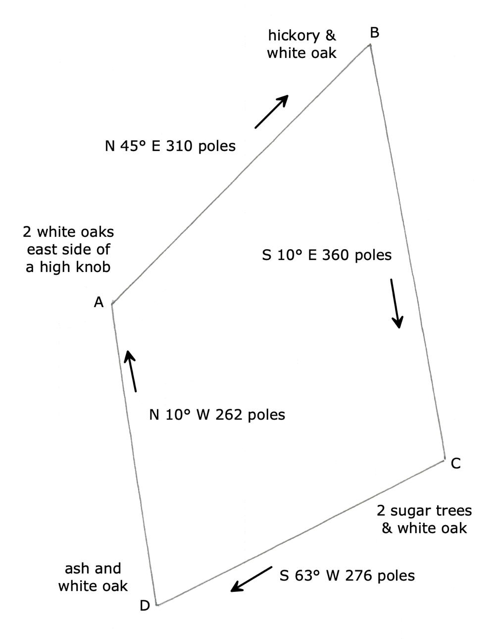
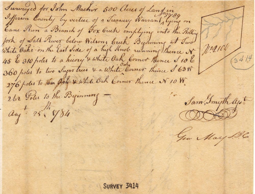
Surveyed for John Macker 500 acres of land in Jefferson County by virtue of a treasury warrant No. 3789 lying on Cane Run, a branch of Fox Creek emptying into the Rolling fork of Salt River below Wilson's Creek. Beginning at two white oaks on the east side of a high knob, running thence N 45 E 310 poles to a hickory & white oak corner, thence S 10 E 360 poles to two sugar trees & a white oak corner, thence S 63 W 276 poles to an ash & white oak corner, thence N 10 W 262 poles to the beginning. August 25th 1784. Sam Smyth, surveyor.
Deed
Virginia Grant Book 8, pages 19-20
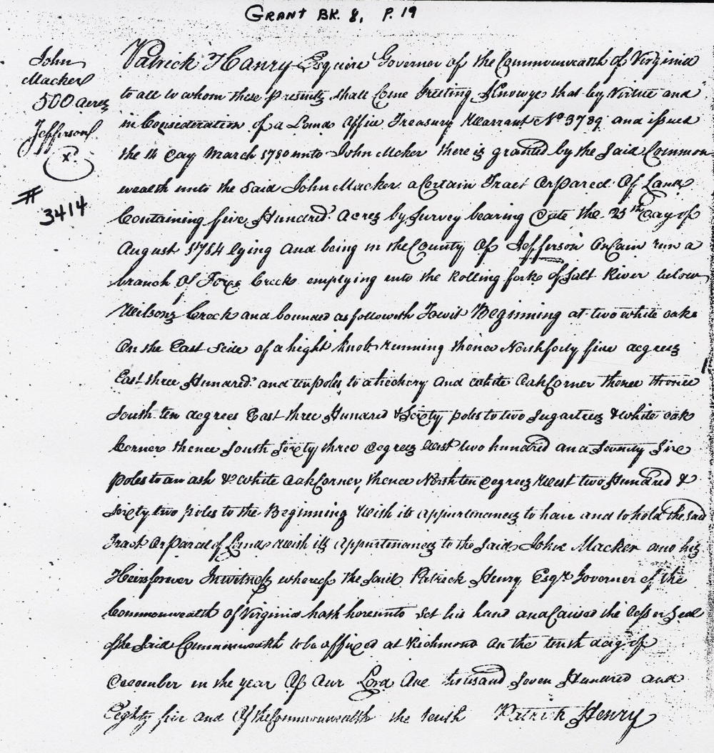
Patrick Henry Esquire, Governor of the Commonwealth of Virginia, to all to whom these presents shall come, greeting. Know ye that by virtue and in consideration of a land office treasury warrant No. 3789 and issued the 14th day March 1780 unto John Macker a certain tract or parcel of land containing five hundred acres by survey bearing date the 25th day of August 1784, lying and being in the county of Jefferson on Cane Run a branch of Fox Creek emptying into the Rolling fork of Salt River below Wilson's Creek, and bounded as followeth, to wit. Beginning at two white oaks on the east side of a high knob, running thence North 45° East 310 poles to a hickory & white oak corner, thence South 10° East 360 poles to two sugar trees & a white oak corner, thence South 63° West 276 poles to an ash & white oak corner, thence North 10° West 262 poles to the beginning with its appurtenances to have and to hold the said tract or parcel of land with its appurtenances to the said John Macker and his heirs forever. In witness whereof the said Patrick Henry Esquire, Governor of the Commonwealth of Virginia, hath hereunto set his hand and caused the lesser seal of the said Commonwealth to be affixed at Richmond on the tenth day of December in the year of our Lord one thousand seven hundred and eighty five and of the Commonwealth the tenth. (signed) Patrick Henry
If you, the reader, have an interest in any particular part of our county history, and wish to contribute to this effort, use the form on our Contact Us page to send us your comments about this, or any Bullitt County History page. We welcome your comments and suggestions. If you feel that we have misspoken at any point, please feel free to point this out to us.
The Bullitt County History Museum, a service of the Bullitt County Genealogical Society, is located in the county courthouse at 300 South Buckman Street (Highway 61) in Shepherdsville, Kentucky. The museum, along with its research room, is open 10 a.m. to 4 p.m. Monday through Friday. Saturday appointments are available by calling 502-921-0161 during our regular weekday hours. Admission is free. The museum, as part of the Bullitt County Genealogical Society, is a 501(c)3 tax exempt organization and is classified as a 509(a)2 public charity. Contributions and bequests are deductible under section 2055, 2106, or 2522 of the Internal Revenue Code. Page last modified: 12 Sep 2024 . Page URL: bullittcountyhistory.org/bchistory/john-macker3414.html