
On 20 Jul 1801, John Macker and Adam Shepherd complete articles of agreement in which they exchanged tracts of land. Macker, who lived in Mason County, accepted tracts owned by Shepherd in Central Kentucky in exchange for the three 500 acre tracts he owned on the waters of Cane Run and Wilson Creek. The deed is transcribed below followed by images of it. The drawings are for reference. Note that they are not drawn to the same scale.
Nelson County Deed Book 7, pages 681-683
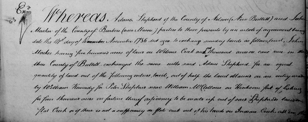
Whereas Adam Shepherd of the County of Nelson (now Bullitt) and John Macker of the County of Bourbon (now Mason) parties to these presents by an article of agreement, bearing date the 14th day of November 1786, did agree to exchange sundry lands as follows, to wit, John Macker, having five hundred acres of land no Wilson's Creek and one thousand acres on Cane Run in the County of Bullitt, exchanged the same with said Adam Shepherd for an equal quantity of land out of the following entries, to wit, out of half the land obtained on an entry by William Kennedy for Peter Shepherd near William McClellan's on Henkson's fork of Linking for four thousand on failure thereof deficiency to be made up out of said Shepherd's land on Flat Creek or if there is not a sufficiency on Flat Creek, out of his lands on Indian creek all in the County of Bourbon.
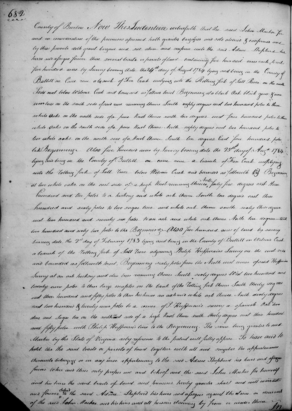
Now this indenture witnesseth that the said John Macker for and in consideration of the premises aforesaid hath granted, bargained and sold, aliened & confirmed and by these presents doth grant, bargain and sell, alien and confirm unto the said Adam Shepherd his heirs and assigns forever three several tracts or parcels of land containing five hundred acres each, to wit; five hundred acres by survey bearing date the 24th day of August 1784, lying and being in the County of Bullitt on Cane Run, a branch of Fox Creek emptying into the Rolling Fork of Salt River on the north side next below Wilson's Creek and bounded as follows to wit;
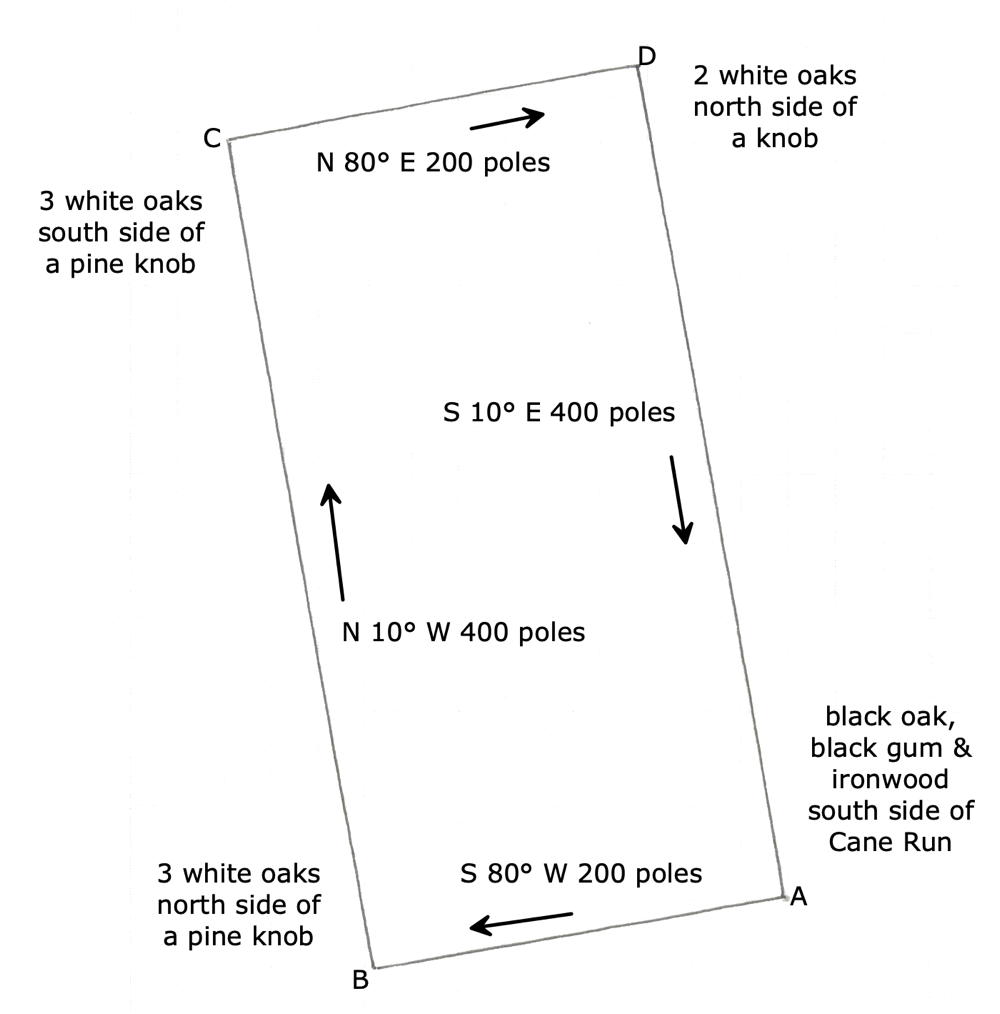
Beginning at a black oak, black gum & ironwood trees on the south side of said run, running thence South eighty degrees West two hundred poles to three white oaks on the north side of a pine knob, thence North ten degrees West four hundred poles to three white oaks on the south side of a pine knob, thence North eighty degrees East two hundred poles to two white oaks on the north side of a knob, thence South ten degrees East four hundred poles to the beginning. Also five hundred acres by survey bearing date the 25th day of August 1784, lying and being in the County of Bullitt on Cane Run, a branch of Fox Creek emptying into the Rolling Fork of Salt River below Wilson's Creek and bounded as followeth, Viz.
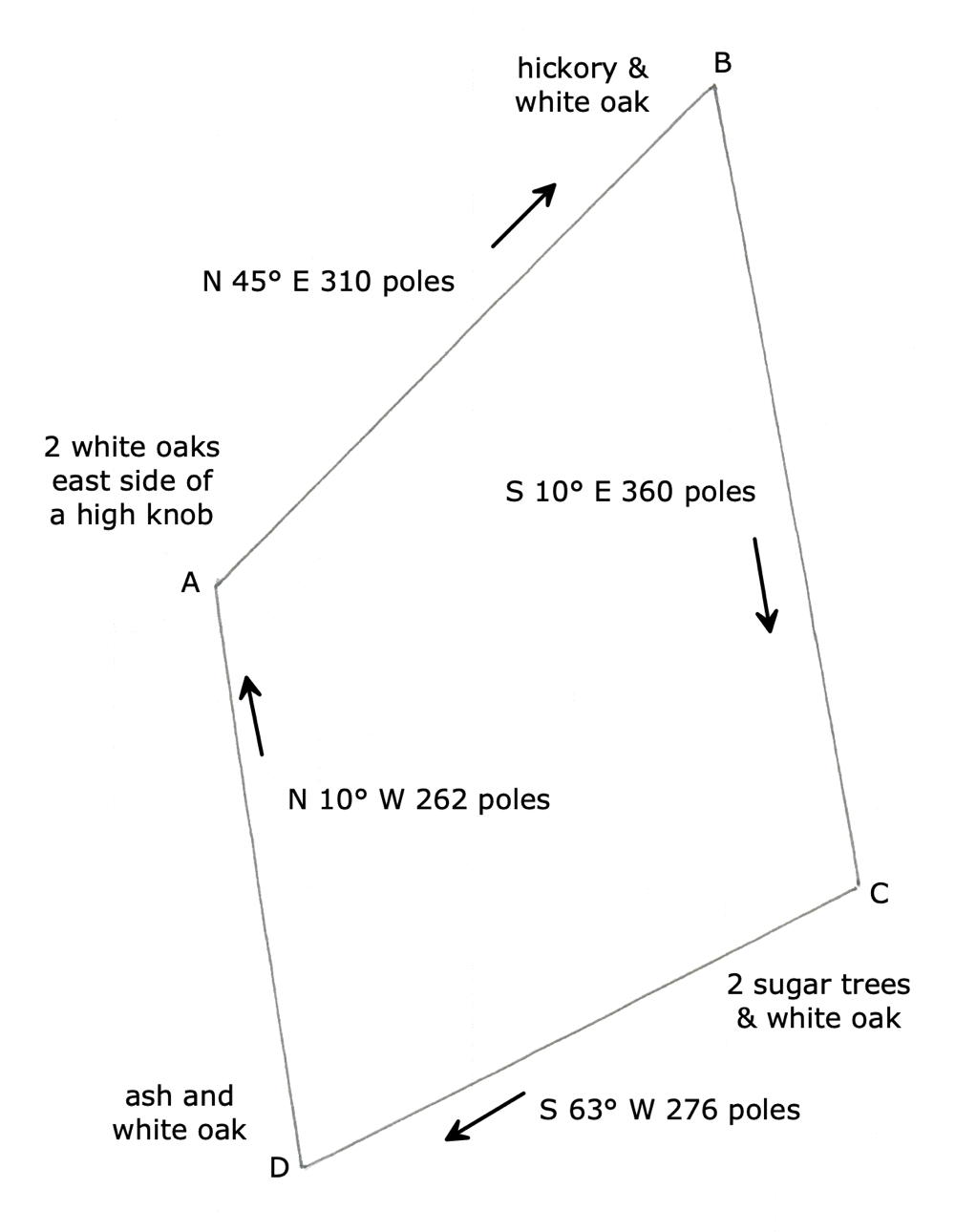
Beginning at two white oaks on the east side of a high knob, running thence North forty five degrees East three hundred and ten poles to a hickory and white oak, thence South ten degrees East three hundred and sixty poles to two sugar trees an white oak, thence South sixty three degrees West two hundred and seventy six poles to an ash and white oak, thence North ten degrees West two hundred and sixty two poles to the beginning. Also five hundred acres of land by survey bearing date the 2nd day of February 1783, lying and being in the County of Bullitt on Wilson's Creek, a branch of the Rolling Fork of Salt River adjoining Philip Huffman's survey on the west side and bounded as followeth to wit;
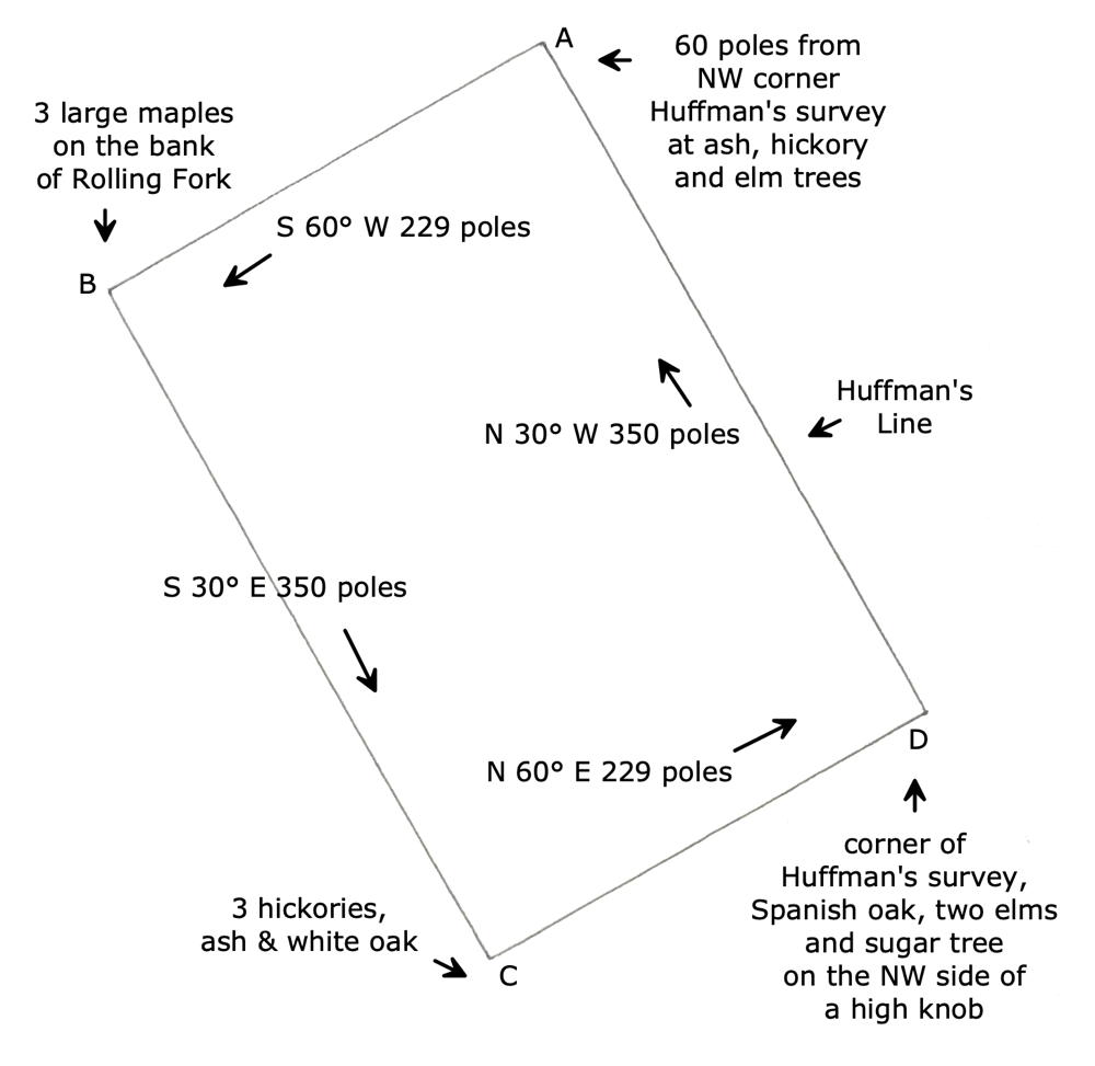
Beginning sixty poles from the North west corner of said Huffman's survey at an ash, hickory and elm trees, running thence South sixty degrees West two hundred and twenty nine poles to three large maples on the bank of the Rolling Fork, thence South thirty degrees East three hundred and fifty poles to three hickories, and ash and white oak, thence North sixty degrees East two hundred & twenty nine poles to a corner of P. Huffman's survey, a Spanish oak, two elms and sugar tree on the northwest side of a high knob, thence North thirty degrees West three hundred and fifty poles with Philip Huffman's line to the beginning.
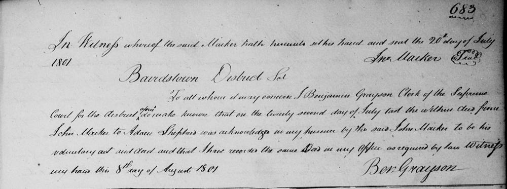
The same being granted to said Macker by the State of Virginia as by reference to the patent will fully appear. To have and to hold the said tracts or parcels of land together with all and singular the appurtenances thereunto belonging or in any wise appertaining to the said Adam Shepherd, his heirs and assigns forever to his and their only proper use and behoof, and the said John Macker for himself and his heirs the said tracts of land and premises hereby granted shall and will warrant and forever defend to the said Adam Shepherd, his heirs and assigns agains the claim or demand of the said John Macker and his heirs and all persons claiming by from or under them. In witness whereof the said Macker hath hereunto set his hand and seal the 20th day of July 1801. (signed) Jno Macker
Bardstown District Sct To all whom it may concern, I Benjamin Grayson, clerk of the Supreme Court for the district aforesaid do make known that on the twenty second day of July last the within deed from John Macker to Adam Shepherd was acknowledged in my presence by the said John Macker to be his voluntary act and deed and that I have recorded the same deed in my office as required by law. Witness my hand this 8th day of August 1801. (signed) Ben Grayson
If you, the reader, have an interest in any particular part of our county history, and wish to contribute to this effort, use the form on our Contact Us page to send us your comments about this, or any Bullitt County History page. We welcome your comments and suggestions. If you feel that we have misspoken at any point, please feel free to point this out to us.
The Bullitt County History Museum, a service of the Bullitt County Genealogical Society, is located in the county courthouse at 300 South Buckman Street (Highway 61) in Shepherdsville, Kentucky. The museum, along with its research room, is open 10 a.m. to 4 p.m. Monday through Friday. Saturday appointments are available by calling 502-921-0161 during our regular weekday hours. Admission is free. The museum, as part of the Bullitt County Genealogical Society, is a 501(c)3 tax exempt organization and is classified as a 509(a)2 public charity. Contributions and bequests are deductible under section 2055, 2106, or 2522 of the Internal Revenue Code. Page last modified: 12 Sep 2024 . Page URL: bullittcountyhistory.org/bchistory/macker-shepherd1500.html