
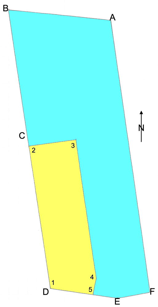
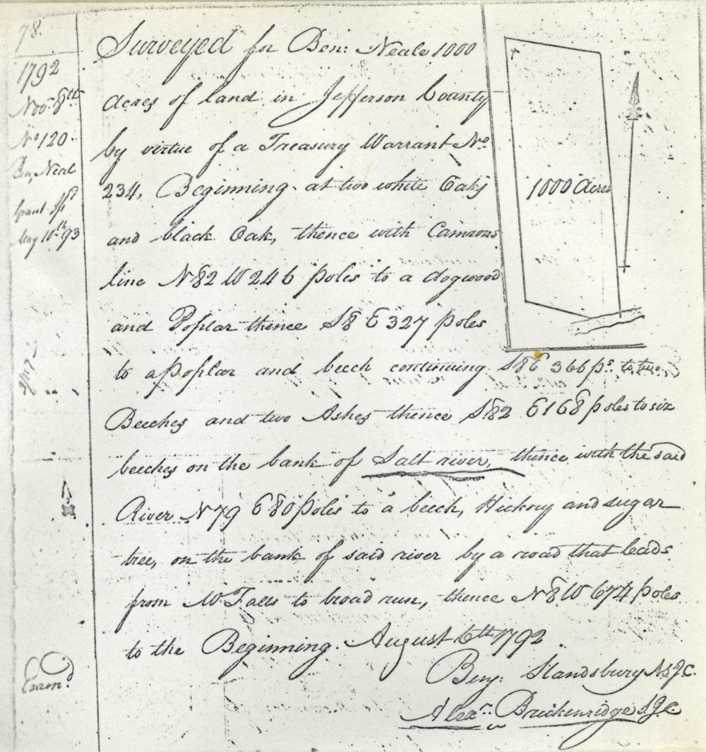
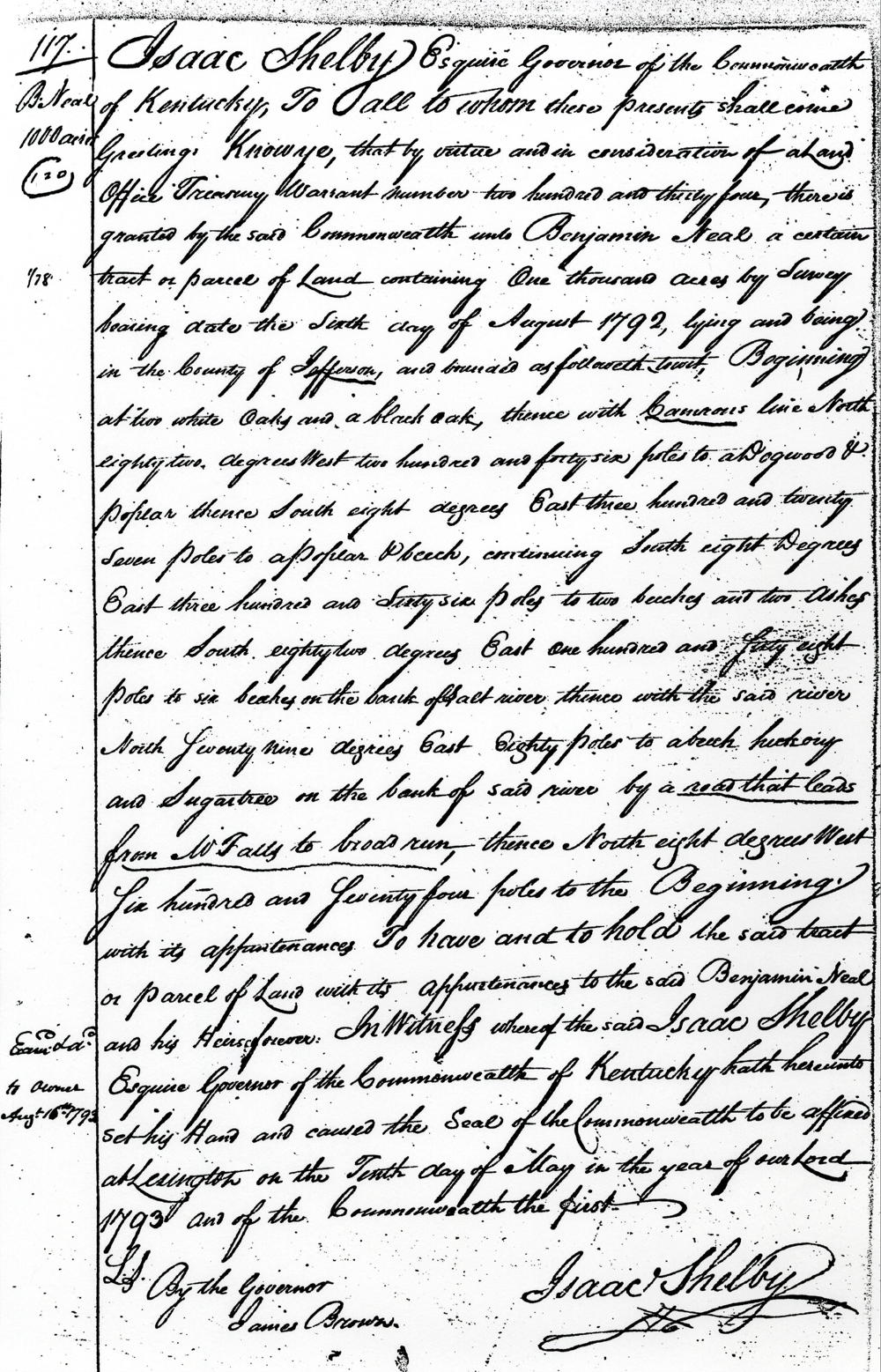
On 6 Aug 1792, Ben Stansbury surveyed 1000 acres north of the Salt River for Benjamin Neale of Bourbon County. Neale received his deed for the land on 10 May 1793. It appears that William Pope had located the available land for Neale, as Neale later deeded 250 acres of it to Pope for doing so. Then later, Neale deeded the remainder to Gabriel, George and Charles Mothershead, his sons-in-law.
Survey
Surveyed for Ben Neale 1000 acres of land in Jefferson County by virtue of a treasury warrant No. 234, beginning at [A] two white oaks and black oak, thence with Camron's line N 82° W 246 poles to [B] a dogwood and poplar, thence S 8° E 327 poles to [C] a poplar and beech continuing S 8° E 366 poles to [D] two beeches and two ashes, thence S 82° E 168 poles to [E] six beeches on the bank of Salt River, thence with the said river N 79° E 80 poles to [F] a beech, hickory and sugar tree on the bank of said river by a road that leads from W Falls to broad run, thence N 8° W 674 poles to the beginning. August 6th 1792. Ben Standsbury, surveyor.
Deed
Isaac Shelby Esquire, governor of the Commonwealth of Kentucky, to all to whom these presents shall come, greeting. Know ye that by virtue and in consideration of a land office treasury warrant number 234 there is granted by the said Commonwealth unto Benjamin Neele a certain tract or parcel of land containing 1000 aces by survey bearing date the 6th day of August 1792, lying and being in the County of Jefferson, and bounded as followeth, to wit. beginning at two white oaks and black oak, thence with Cameron's line North 82° West 246 poles to a dogwood and poplar, thence South 8° East 327 poles to a poplar and beech, continuing South 8° E 366 poles to two beeches and two ashes, thence South 82° E 168 poles to six beeches on the bank of Salt River, thence with the said river North 79° East 80 poles to a beech, hickory and sugar tree on the bank of said river by a road that leads from W Falls to broad run, thence North 8° West 674 poles to the beginning with its appurtenances. To have and to hold the said tract or parcel of land with its appurtenances to the said Benjamin Neal and his heirs forever. In witness whereof the said Isaac Shelby Esquire, governor of the Commonwealth of Kentucky, hath hereunto set his hand and caused the seal of the Commonwealth to be affixed at Lexington on the 10th day of May in the year of our Lord 1793, and of the Commonwealth the first. (signed) Isaac Shelby
If you, the reader, have an interest in any particular part of our county history, and wish to contribute to this effort, use the form on our Contact Us page to send us your comments about this, or any Bullitt County History page. We welcome your comments and suggestions. If you feel that we have misspoken at any point, please feel free to point this out to us.
The Bullitt County History Museum, a service of the Bullitt County Genealogical Society, is located in the county courthouse at 300 South Buckman Street (Highway 61) in Shepherdsville, Kentucky. The museum, along with its research room, is open 10 a.m. to 4 p.m. Monday through Friday. Saturday appointments are available by calling 502-921-0161 during our regular weekday hours. Admission is free. The museum, as part of the Bullitt County Genealogical Society, is a 501(c)3 tax exempt organization and is classified as a 509(a)2 public charity. Contributions and bequests are deductible under section 2055, 2106, or 2522 of the Internal Revenue Code. Page last modified: 12 Sep 2024 . Page URL: bullittcountyhistory.org/bchistory/ok0129-neale.html