
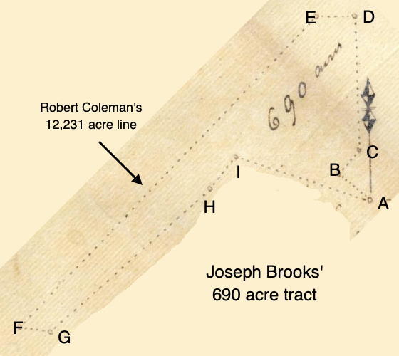
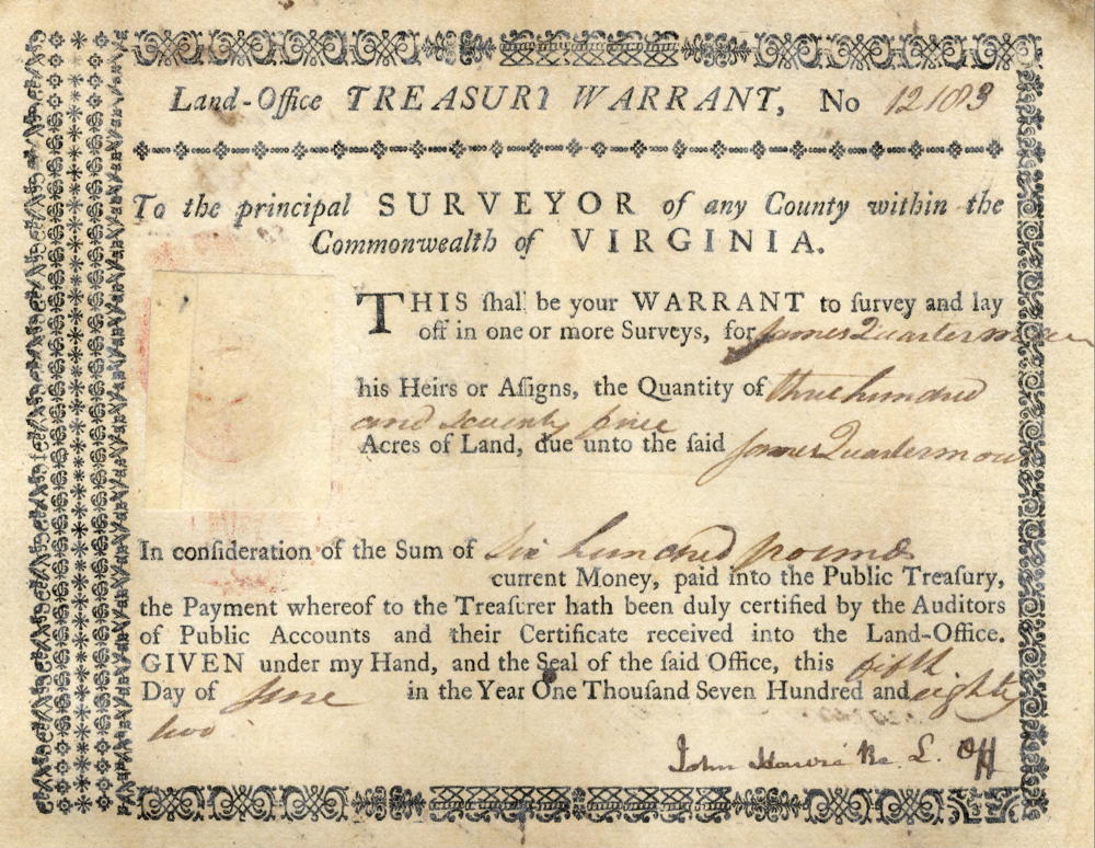
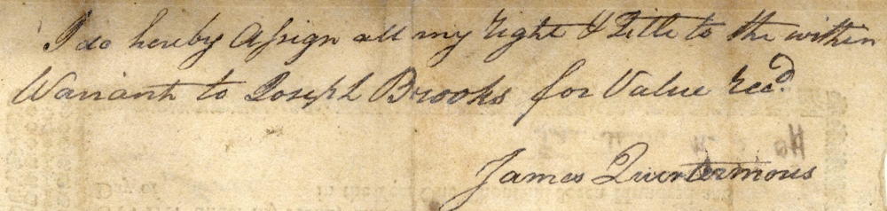
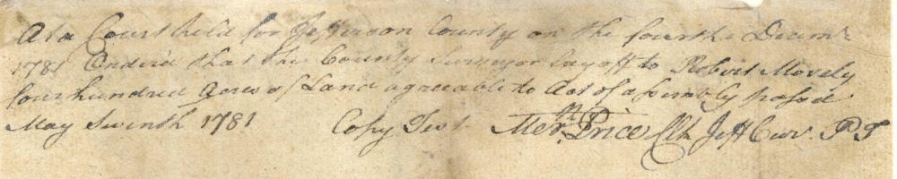
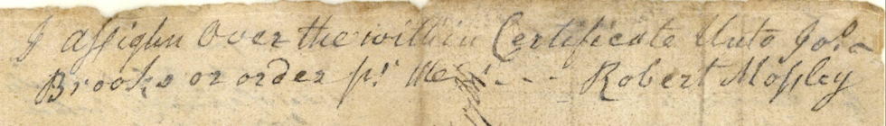
On 1 Nov 1792, Robert Breckinridge surveyed a tract of 690 acres for Joseph Brooks in what would become part of northern Bullitt County. Brooks had obtained the right to this acreage by way of a treasury warrant in the name of James Quartermouse who signed it over to Brooks; and by way of a poor certificate he obtained from Robert Mossley. Brooks would get his deed to the land on 20 May 1793.
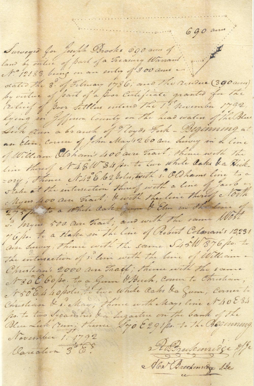
Survey
Surveyed for Joseph Brooks 690 acres of land by virtue of part of a treasury warrant No. 12183 being on an entry of 300 acres dated the 3rd of February 1786, and the residue (390 acres) by virtue of part of a poor certificate granted for the relief of poor settlers entered the 1st November 1792, lying in Jefferson County on the head waters of the Blue Lick run, a branch of Floyd's Fork - Beginning at [A] an elm, corner of John May's 260 acre survey in a line of William Oldham's 400 acre tract, thence with the line thereof N 48° W 84 poles to [B] two white oaks & a hickory, thence N 42° E 62 poles with said Oldham's line to [C] a stake at the intersection thereof with a line of Jacob Myers' 400 acre tract, & with the line thereof North 275 poles to [D] a white oak, gum & elm in the line of said Myers' 500 acre tract, and with the same West 76 poles to [E] a stake in the line of Robert Coleman's 12,231 acre survey, thence with the same S 45° W 876 poles to [F] the intersection of said line with the line of William Christian's 2000 acre tract, thence with the same N 80° E 60 poles to [G] a gum & beech, corner to Christian, N 50° E 440 poles to [H] two white oaks & a gum, corner to Christian & said May, thence with May's line, N 40° E 84 poles to [I] two sycamores & a sugartree on the bank of the Blue Lick run, thence S 70° E 291 poles to the beginning. November 1, 1792. Robert Breckinridge, surveyor.
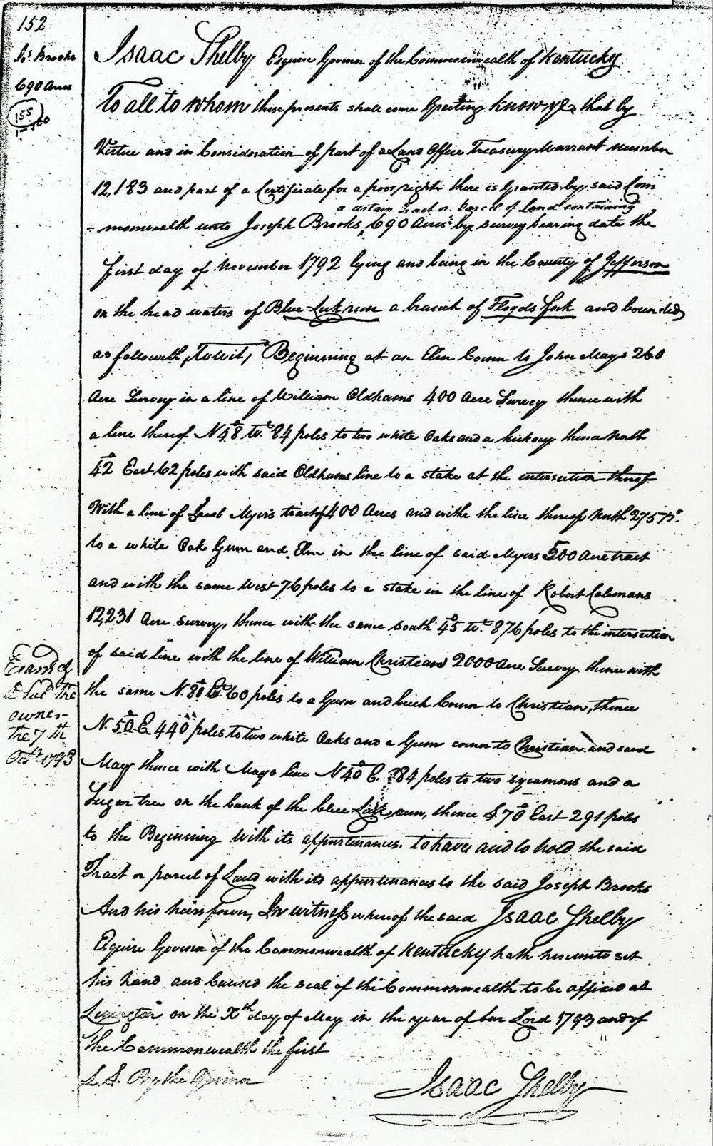
Deed
Isaac Shelby Esquire, governor of the Commonwealth of Kentucky, to all to whom these presents shall come, greeting. Know ye that by virtue and in consideration of part of a land of a treasury warrant number 12,183, and part of a certificate for a poor right, there is granted by said Commonwealth unto Joseph Brooks a certain tract or parcel of land containing 690 acres by survey bearing date the first day of November 1792, lying and being in the county of Jefferson and the headwaters of Blue Lick run, a branch of Floyd's fork, and bounded as followeth, to wit. Beginning at an elm, corner to John May's 260 acre survey in a line of William Oldham's 400 acre survey, thence with the line thereof N 48° W 84 poles to two white oaks & a hickory, thence North 42° East 62 poles with said Oldham's line to a stake at the intersection thereof with a line of Jacob Myers' tract of 400 acres, and with the line thereof North 275 poles to a white oak, gum & elm in the line of said Myers' 500 acre tract, and with the same West 76 poles to a stake in the line of Robert Coleman's 12,231 acre survey, thence with the same South 45° W 876 poles to the intersection of said line with the line of William Christian's 2000 acre survey, thence with the same N 80° E 60 poles to a gum & beech, corner to Christian, thence N 50° E 440 poles to two white oaks and a gum, corner to Christian & said May, thence with May's line, N 40° E 84 poles to two sycamores & a sugar tree on the bank of the Blue Lick run, thence S 70° East 291 poles to the beginning with its appurtenances to have and to hold the said tract or parcel of land with its appurtenances to the said Joseph Brooks and his heirs forever. In witness whereof the said Isaac Shelby Esquire, Governor of the Commonwealth of Kentucky hath hereunto set his hand and caused the seal of the Commonwealth to be affixed at Lexington on the 20th day of May in the year of our Lord 1793, and of the Commonwealth the first. (signed) Isaac Shelby
Warrant & Related Documents
If you, the reader, have an interest in any particular part of our county history, and wish to contribute to this effort, use the form on our Contact Us page to send us your comments about this, or any Bullitt County History page. We welcome your comments and suggestions. If you feel that we have misspoken at any point, please feel free to point this out to us.
The Bullitt County History Museum, a service of the Bullitt County Genealogical Society, is located in the county courthouse at 300 South Buckman Street (Highway 61) in Shepherdsville, Kentucky. The museum, along with its research room, is open 10 a.m. to 4 p.m. Monday through Friday. Saturday appointments are available by calling 502-921-0161 during our regular weekday hours. Admission is free. The museum, as part of the Bullitt County Genealogical Society, is a 501(c)3 tax exempt organization and is classified as a 509(a)2 public charity. Contributions and bequests are deductible under section 2055, 2106, or 2522 of the Internal Revenue Code. Page last modified: 12 Sep 2024 . Page URL: bullittcountyhistory.org/bchistory/ok0155-brooks.html