
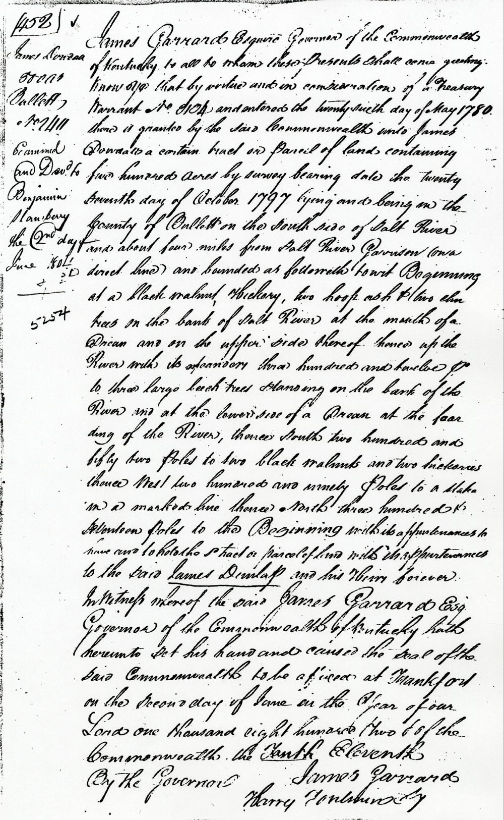
On 27 Oct 1797, James Shanks surveyed 500 acres for James Dowdall on the south side of Salt River, adjoining the river about four miles upstream from Salt River Garrison which was also called Brashear's Station. A deed for the tract was issued on 2 Jun 1802. There is some confusion regarding the deed, as it named James Dowdall in one place, and James Dunlap in another place; and along the margin of the deed, it states, "Examined and delivered to Benjamin Stansberry the 2nd day of June 1802."
Then on 9 Mar 1805, Dowdall sold the tract to Henry Crist.
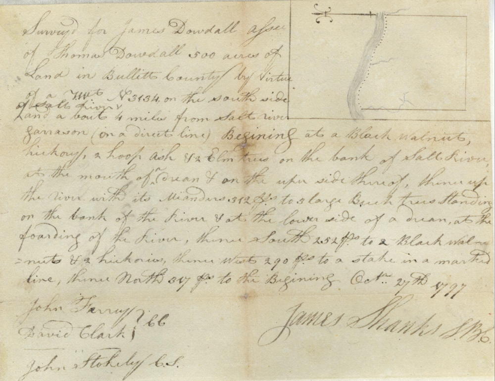
Survey
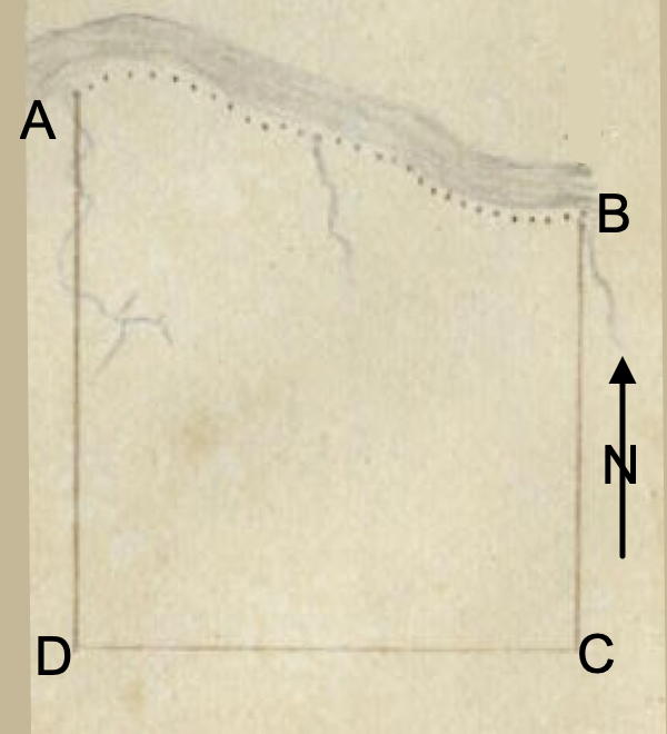
Surveyed for James Dowdall, assignee of Thomas Dowdall, 500 acres of land in Bullitt County by virtue of a treasury warrant No. 3134 on the south side of Salt River about 4 miles from Salt River Garrison (on a direct line) Beginning at a black walnut, hickory, two hoop ash and two elm trees on the bank of Salt River at the mouth of a drain and on the upper side thereof, thence up the river with its meanders 312 poles to three large beech trees standing on the bank of the river and at the lower side of a drain at the fording of the river, thence South 252 poles to two black walnuts and two hickories, thence West 290 poles to a stake in a marked line, thence North 317 poles to the beginning. October 27th 1797. James Shanks, surveyor. John Ferry & David Clark, chain carriers. John Stokely, C.S.
Deed
James Garrard Esquire, governor of the Commonwealth of Kentucky, to all to whom these presents shall come, greeting. Know ye that by virtue and in consideration of a treasury warrant number 8104 and entered the 26th day of May 1780, there is granted by the said Commonwealth unto James Dowdall a certain tract or parcel of land containing 500 acres by survey bearing date the 27th day of October 1797, lying and being in the county of Bullitt on the waters of Salt River and about four miles from Salt River Garrison (on a direct line) and bounded as followeth, to wit. Beginning at a black walnut, hickory, two hoop ash and two elm trees on the bank of Salt River at the mouth of a drain and on the upper side thereof, thence up the river with its meanders 312 poles to three large beech trees standing on the bank of the river and at the lower side of a drain at the fording of the river, thence South 252 poles to two black walnuts and two hickories, thence West 290 poles to a stake in a marked line, thence North 317 poles to the beginning with its appurtenances to the said James Dunlap and his heirs forever. In witness whereof the said James Garrard Esquire, Governor of the Commonwealth of Kentucky, hath hereunto set his hand and caused the seal of the said Commonwealth to be affixed at Frankfort on the 2nd day of June in the year of our Lord 1802, and of the Commonwealth the eleventh. (signed) James Garrard
If you, the reader, have an interest in any particular part of our county history, and wish to contribute to this effort, use the form on our Contact Us page to send us your comments about this, or any Bullitt County History page. We welcome your comments and suggestions. If you feel that we have misspoken at any point, please feel free to point this out to us.
The Bullitt County History Museum, a service of the Bullitt County Genealogical Society, is located in the county courthouse at 300 South Buckman Street (Highway 61) in Shepherdsville, Kentucky. The museum, along with its research room, is open 10 a.m. to 4 p.m. Monday through Friday. Saturday appointments are available by calling 502-921-0161 during our regular weekday hours. Admission is free. The museum, as part of the Bullitt County Genealogical Society, is a 501(c)3 tax exempt organization and is classified as a 509(a)2 public charity. Contributions and bequests are deductible under section 2055, 2106, or 2522 of the Internal Revenue Code. Page last modified: 12 Sep 2024 . Page URL: bullittcountyhistory.org/bchistory/ok5254-dowdall.html