
Thomas Whitledge surveyed 400 acres for William Pope, assignee of Joshua Archer, and Paul Froman on 24 Feb 1784. It lay between the surveys of George May and John Edwards. The transcribed survey and deed are below. On the survey drawing, the top is south.
Survey
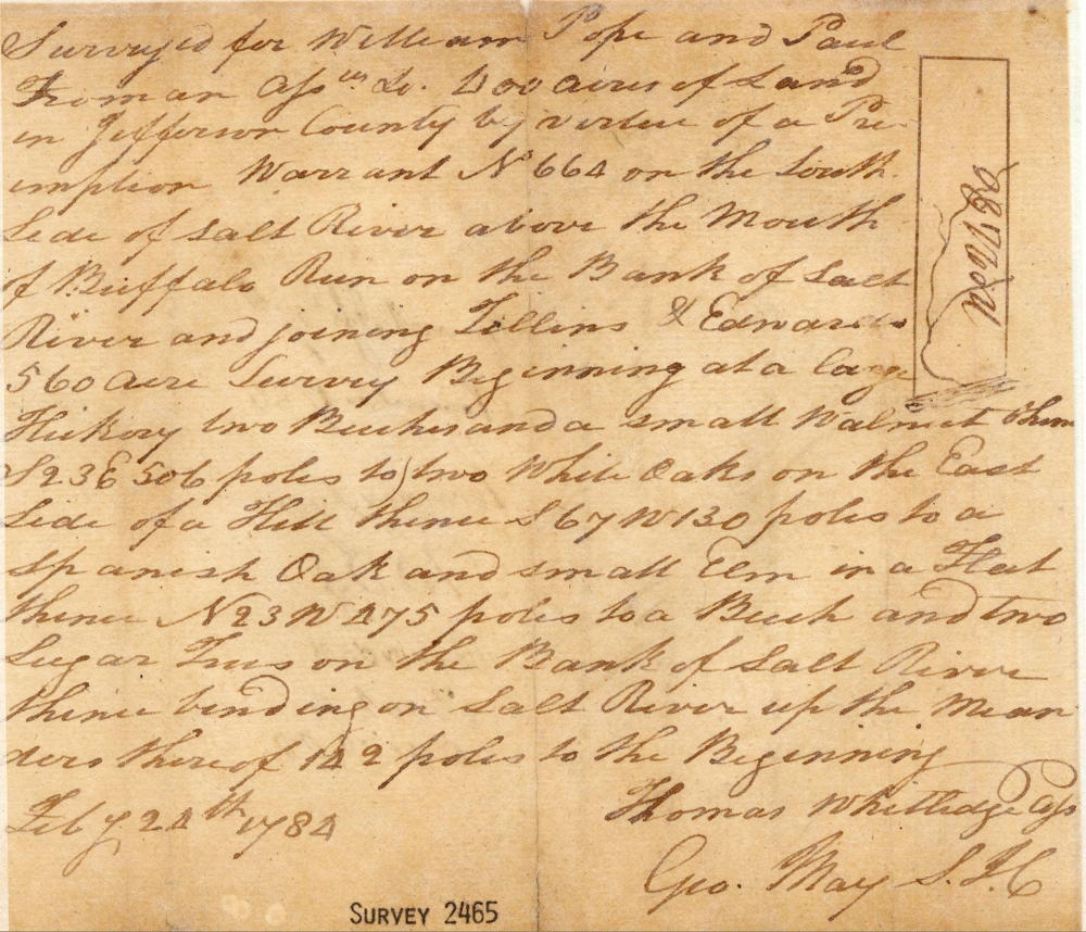
Surveyed for William Pope and Paul Froman assignee &c 400 acres of land in Jefferson County by virtue of a preemption warrant No. 664 on the South side of Salt River above the mouth of Buffalo Run on the bank of Salt River and joining Tillins & Edwards 560 acre survey Beginning at a large hickory, two beeches and a small walnut, thence S 23 E 506 poles to two white oaks on the east side of a hill, thence S 67 W 130 poles to a Spanish oak and small elm in a flat, thence N 23 W 475 poles to a beech and two sugar trees on the bank of Salt River, thence binding on Salt River up the meanders thereof 142 poles to the Beginning. Feby 24th, 1784 (signed) Thomas Whitledge, Assistant Surveyor
Deed
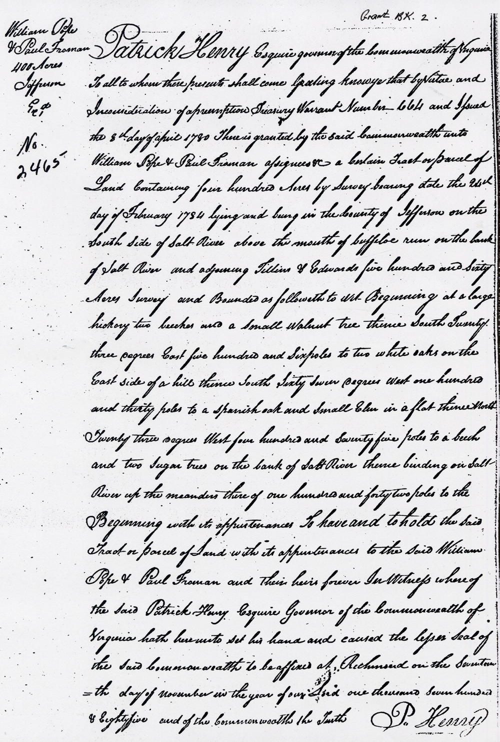
Grant Book 2
Patrick Henry Esquire, Governor of the Commonwealth of Virginia to all to whom these presents shall come. Greeting, know ye that by virtue and in consideration of a preemption treasury warrant Number 664 and issued the 8th day of April 1780, there is granted by the said Commonwealth unto William Pope & Paul Froman assignees &c a certain tract or parcel of land containing four hundred acres by survey bearing date the 24th day of February 1784 lying and being in the county of Jefferson on the south side of Salt River above the mouth of Buffalo Run on the bank of Salt River and adjoining Tillins & Edwards five hundred and sixty acres survey and bounded as followeth to wit. Beginning at a large hickory, two beeches and a small walnut tree, thence South twenty three degrees East five hundred and six poles to two white oaks on the East side of a hill, thence South sixty seven degrees West on hundred and thirty poles to a Spanish oak and small elm in a flat, thence North twenty three degrees West four hundred and seventy five poles to a beech and two sugar trees on the bank of Salt River, thence binding on Salt River up the meanders thereof on hundred and forty two poles to the Beginning with it appurtenances to have and to hold the said tract or parcel of land with its appurtenances to the said William Pope & Paul Froman and their heirs forever. In witness whereof the said Patrick Henry Esquire, Governor of the Commonwealth of Virginia hath hereunto set his hand and caused the lesser seal of the said Commonwealth to be affixed at Richmond on the seventeenth day of November in the year of out Lord one thousand seven hundred & eighty five and of the Commonwealth the Fourth. (signed) P. Henry
If you, the reader, have an interest in any particular part of our county history, and wish to contribute to this effort, use the form on our Contact Us page to send us your comments about this, or any Bullitt County History page. We welcome your comments and suggestions. If you feel that we have misspoken at any point, please feel free to point this out to us.
The Bullitt County History Museum, a service of the Bullitt County Genealogical Society, is located in the county courthouse at 300 South Buckman Street (Highway 61) in Shepherdsville, Kentucky. The museum, along with its research room, is open 10 a.m. to 4 p.m. Monday through Friday. Saturday appointments are available by calling 502-921-0161 during our regular weekday hours. Admission is free. The museum, as part of the Bullitt County Genealogical Society, is a 501(c)3 tax exempt organization and is classified as a 509(a)2 public charity. Contributions and bequests are deductible under section 2055, 2106, or 2522 of the Internal Revenue Code. Page last modified: 12 Sep 2024 . Page URL: bullittcountyhistory.org/bchistory/pope-froman.html