
by Charles Hartley
First published in The Pioneer News in June 2023.
In this article we will be attempting to determine the place where Adam Shepherd established a ferry across Salt River near Shepherdsville in the early years of our county's history; and also what became of it.
By the Fall of 1797, Shepherd's family was living in their home located on the waters of Long Lick Creek. With Shepherdsville lying on the north side of Salt River they, along with many of their neighbors, had frequent need to cross Salt River.
The old ferry upstream between the Pope farm and the former Dowdall's Station was likely still crossing the river, but it was becoming an out of the way route, and on November 28th Shepherd petitioned the county court to allow him to operate a ferry. This was likely not only for convenience but also for profit, as Adam Shepherd was a businessman who was always open to new opportunities.
The court order (Bullitt County Order Book A, Pages 54-55) read, "On the motion of Adam Shepherd by his agent Joseph Saunders, ordered that he have leave to keep a ferry across Salt River at Shepherdsville upon his entering into bond in the clerk's office of this court with Benjamin Pope, Joseph Saunders and Thomas Speed his securities, conditioned that he shall keep one good and sufficient boat for the transportation of a wagon and two horses to be attended by three men and to keep the said ferry according to law; the fee for taking over a horse, four pence; man and horse, eight pence."
It appears that Shepherd decided to establish his ferry at the southeastern tip of the 900 acre survey granted to his father, Peter Shepherd in 1782. This was located on the river next to Shepherd's boundary with the old McGee tract. We know this from a deed and plat located in Bullitt County Deed Book F, Pages 290-293, produced by William Pope Jr. that shows the location.
It appears from that deed, that Adam Shepherd's hold on his father's 900 and 600 acre surveys bordering Salt River had been forfeited by court order some time before 1803, and Pope had purchased the land at a public sale ordered by the District Court of Kentucky. Pope and Shepherd may have had some kind of arrangement, for by this deed Pope returned ownership of part of these tracts to Shepherd's daughters Sally and Charlotte Shepherd in March 1827. The plat drawing accompanying the deed showed the then-current ownership of various parts of these two tracts, and almost as an afterthought included the brief statement, "The triangle Nos. 3, 4 and 2 bounded with black lines and marked P represents Griffin's or Mocaby's 6¾ acres."
As a side note, the Mocaby mentioned above might have been William Mockbee, a hatter who lived in Shepherdsville, and had purchased land just north of town from Adam Shepherd. I'm not certain why he was mentioned in this deed record.
This deed also describes the measurement of the 900 acre tract, and indicates that it traveled "up Salt River and binding thereon to No. 2 where it is supposed that a sugar tree and two beeches stood, it being Shepherd's and McGee's corner."
This triangle was shown on the plat at the southeastern corner of the 900 acre tract, as shown on the left-hand drawing here. Keep the name Griffin, the marker at No. 2, and the 6¾ acres in mind as we proceed.
To add the next piece to our puzzle, we turn back to the establishment of the town of Shepherdsville in 1797. After the legislature established the town, Benjamin Stansbury was tasked with laying out its boundaries. He began "at a large beech and an ash on the bank of Salt River above a small gut, thence North 6½ degrees East 1306½ feet to a stake." Then, when James Shanks re-drew the lines in 1808, he began "at a stake near a large beech on the bank of Salt River alluded to by Benjamin Stansbury, running thence North 6 degrees 30 minutes East 1306½ feet." In both cases the significant marker was that beech tree on the bank of the river, with the eastern boundary of the town being specified. In both cases that eastern boundary lay along the path of a street named appropriately East Street.
Thus, the beech tree was said to lie on the bank of the river at the point where the outer edge of East Street arrived at the river. East Street, or at least a part of it, still exists today, lying east of the railroad tracks and extending northward from Joe B. Hall Avenue. This will be important as we continue to join the pieces of our puzzle.
The next piece comes from an 1810 deed between the heirs of Peter Shepherd and the brothers John W. and Upton Beckwith (Bullitt County Deed Book B, Pages 401-2). In it, Peter Shepherd's heirs sold about 18 acres to the Beckwiths that began "at a large beech tree on the bank of said river, one of the corners of the town of Shepherdsville, thence North 6 degrees East 17½ poles to a stake, thence South 84 degrees East 80 poles to a stake, thence South 6 degrees West 33 poles to Salt River, thence with the meanders of it to a point opposite the beginning, then to the beginning." As a reminder, a pole measured 16½ feet.
Once again we have the beech tree corner to the town as a marker. Since we know that this is where the original East Street met the river, we can use that as the beginning point to plot this Beckwith tract. This will become important to the next puzzle piece.
Adam Shepherd continued to operate his ferry across Salt River for more than a dozen years, but in June 1810 he sold 6¾ acres on the north side of the river to John Scott Jr. that included the ferry site, as the deed (Bullitt County Deed Book B, Page 381) specified, "It is further agreed between the parties that his, the said Adam Shepherd's family is to be ferried over Salt River at the said Scott's ferry without paying anything therefor."
Scott almost immediately sold the same tract to John Griffin (Bullitt County Deed Book B, Pages 382-383) with the same requirement that "it is agreed by and between the parties that Adam Shepherd and his family are to be ferried over the said ferry without paying therefor."
Thus we now have the ferry tract of 6¾ acres in the hands of John Griffin. In both the Shepherd to Scott deed and the Scott to Griffin deed, the tract is described as "beginning at John McGee's southwestwardly corner of sugar tree and beech, running thence South 58 degrees West 44 poles to John W. & U. Beckwith's corner to an ash tree on the bank of Salt River, North 6 degrees East 64 poles to a stake in John McGee's line, thence South 35 degrees East 50 poles to the beginning."
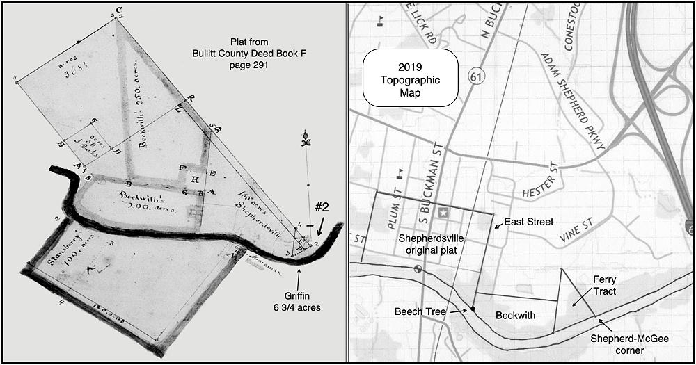
Thus we may begin by extending East Street on a modern topographic map to the river where our beech tree once stood, and use that as our beginning point. From there we follow the boundary lines for the Beckwith tract, and having drawn them, we may now use the Griffin deed measures to connect McGee's corner (#2 on Pope's plat) to Beckwith's southeast corner at the river, and then complete the triangle back to its beginning, as shown on the modern map.
Today that ferry tract would lie between the river and the east side of the go-cart track at Kart Kountry.
With our puzzle complete, we turn now to the rest of our story. John and Elizabeth Griffin officially took over the operation of the ferry in February 1811 when the county court clerk recorded in the order book, "On motion of John Griffin, leave given him to keep a ferry opposite his place about half a mile from Shepherdsville, he entered into bond with James Caldwell, conditioned on due performance of duty."
The following November, John Griffin was appointed as a county constable, giving him additional responsibilities and sources of income. He seems to have prospered for by the following June he was able to purchase lot #79 in Shepherdsville from Ben Summers. This lot lay on the river near the southeast corner of town, only a short distance from the ferry landing, enabling him to live in town and travel early each morning to tend to his ferry business.
Unfortunately, within two years John Griffin was dead, leaving Elizabeth a widow with a ferry business to operate. She appears to have continued the operation for a time, even getting the county court to open a public road from town to the ferry landing. But, in November 1820, Elizabeth sold the ferry tract to John Graham for fifty dollars, and the following April the county clerk recorded, "John Graham entered into bond of $1000 with Joseph A. Brooks his security for keeping a ferry across Salt River above Shepherdsville where Elizabeth Griffins formerly kept one."
As for Elizabeth Griffin, times appeared to be difficult. At the April 1824 court, it was ordered "that the collector of Bullitt County pay to Jonathan Gore Jr. $25 out of levy collectable in 1824 to be appropriated for the benefit of Mrs. Elizabeth Griffin, a poor woman." And the last we know of her, the court, in November 1826, allotted her $25 "if she remains in the county."
The ferry's days were numbered. In October 1821, Francis Maraman obtained the court's permission to establish a ferry across Salt River above the head of the falls near Shepherdsville where he owned land on both sides of the river. This was still closer to town, and quickly became the preferred passage, bringing an end to the ferry begun by Adam Shepherd some 24 years earlier.
If you, the reader, have an interest in any particular part of our county history, and wish to contribute to this effort, use the form on our Contact Us page to send us your comments about this, or any Bullitt County History page. We welcome your comments and suggestions. If you feel that we have misspoken at any point, please feel free to point this out to us.
The Bullitt County History Museum, a service of the Bullitt County Genealogical Society, is located in the county courthouse at 300 South Buckman Street (Highway 61) in Shepherdsville, Kentucky. The museum, along with its research room, is open 10 a.m. to 4 p.m. Monday through Friday. Saturday appointments are available by calling 502-921-0161 during our regular weekday hours. Admission is free. The museum, as part of the Bullitt County Genealogical Society, is a 501(c)3 tax exempt organization and is classified as a 509(a)2 public charity. Contributions and bequests are deductible under section 2055, 2106, or 2522 of the Internal Revenue Code. Page last modified: 12 Sep 2024 . Page URL: bullittcountyhistory.org/bchistory/shepherd-griffin-ferry.html