
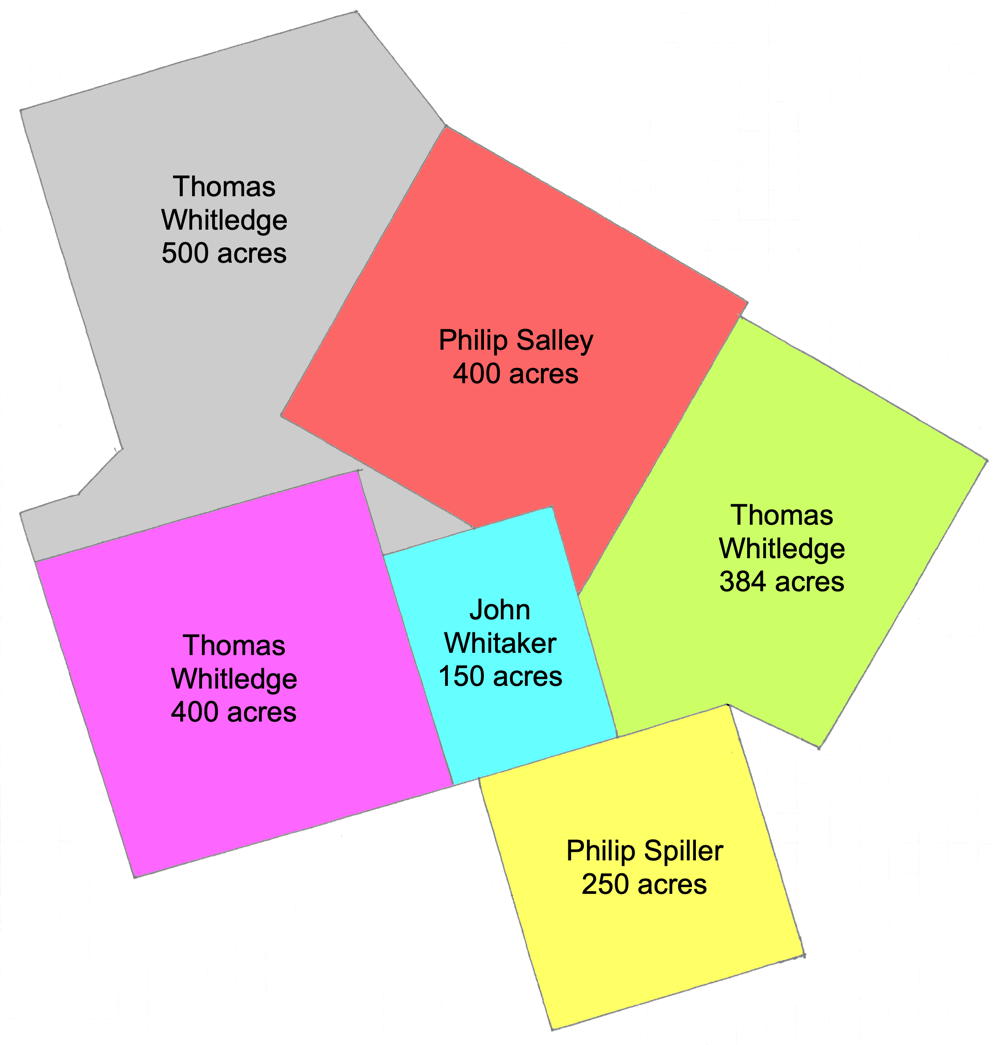
Thomas Whitledge surveyed this 150 acre tract on Cox's Creek for John Whitaker on 28 Feb 1783, who received the deed for it on 2 Dec 1785. As shown here, it adjoined Whitlege's 384, 400 and 500 acre tracts as well as Philip Salley's 400 acres and Philip Spiller's 250 acres.
Survey
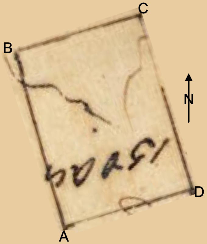
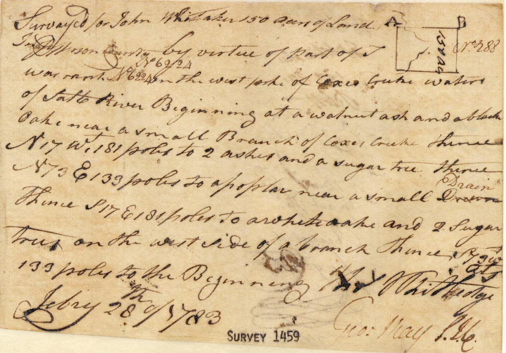
Surveyed for John Whitaker 150 acres of land in Jefferson County by virtue of part of treasury warrant No. 6224 on the west side of Coxes Creek waters of Salt River, beginning at [A] a walnut, ash and a black oak near a small branch of Coxes Creek, thence N 17° W 181 poles to [B] 2 ashes and a sugar tree, thence N 73° E 133 poles to [C] a poplar near a small drain, thence S 17° E 181 poles to [D] a white oak and 2 sugar trees on the west side of a branch, thence S 73° W 133 poles to the beginning. February 28th 1783. Thomas Whitledge, surveyor.
Deed
Virginia Grant Book 10, page 105
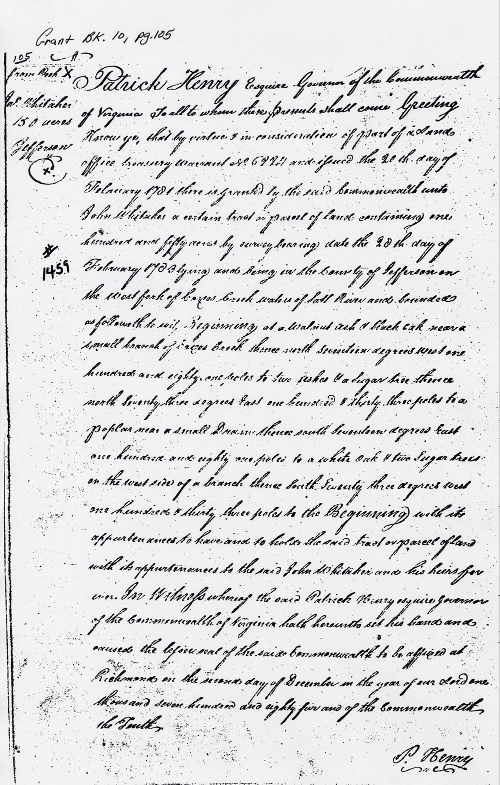
Patrick Henry Esquire, Governor of the Commonwealth of Virginia, to all to whom these presents shall come, greeting. Know ye that by virtue and in consideration of part of a land office treasury warrant No. 6224 issued the 20th day of February 1781, there is granted by the said Commonwealth unto John Whitaker a certain tract or parcel of land containing 150 acres by survey bearing date the 20th day of February 1783, lying and being in the county of Jefferson on the west fork of Coxes Creek waters of Salt River and bounded as followeth to wit. Beginning at a walnut, ash and a black oak near a small branch of Coxes Creek, thence North 17° West 181 poles to 2 ashes and a sugar tree, thence North 73° East 133 poles to a poplar near a small drain, thence South 17° East 181 poles to a white oak and 2 sugar trees on the west side of a branch, thence South 73° West 133 poles to the beginning with its appurtenances to have and to hold the said tract or parcel of land with its appurtenances to the said John Whitaker and his heirs forever. In witness whereof the said Patrick Henry Esquire, Governor of the Commonwealth of Virginia, hath hereunto set his hand and caused the lesser seal of the said Commonwealth to be affixed at Richmond on the 2nd day of December in the year of our Lord 1785 and of the Commonwealth the 10th. (signed) P. Henry
If you, the reader, have an interest in any particular part of our county history, and wish to contribute to this effort, use the form on our Contact Us page to send us your comments about this, or any Bullitt County History page. We welcome your comments and suggestions. If you feel that we have misspoken at any point, please feel free to point this out to us.
The Bullitt County History Museum, a service of the Bullitt County Genealogical Society, is located in the county courthouse at 300 South Buckman Street (Highway 61) in Shepherdsville, Kentucky. The museum, along with its research room, is open 10 a.m. to 4 p.m. Monday through Friday. Saturday appointments are available by calling 502-921-0161 during our regular weekday hours. Admission is free. The museum, as part of the Bullitt County Genealogical Society, is a 501(c)3 tax exempt organization and is classified as a 509(a)2 public charity. Contributions and bequests are deductible under section 2055, 2106, or 2522 of the Internal Revenue Code. Page last modified: 12 Sep 2024 . Page URL: bullittcountyhistory.org/bchistory/whitaker1459.html