
Thomas Whitledge surveyed a 500 acre tract for William Shannon on 25 June 1784 on the south side of Salt River near Cedar Creek. A deed to the tract was issued on 17 Mar 1790. Both survey and deed are shown below, together with their transcriptions.
Survey
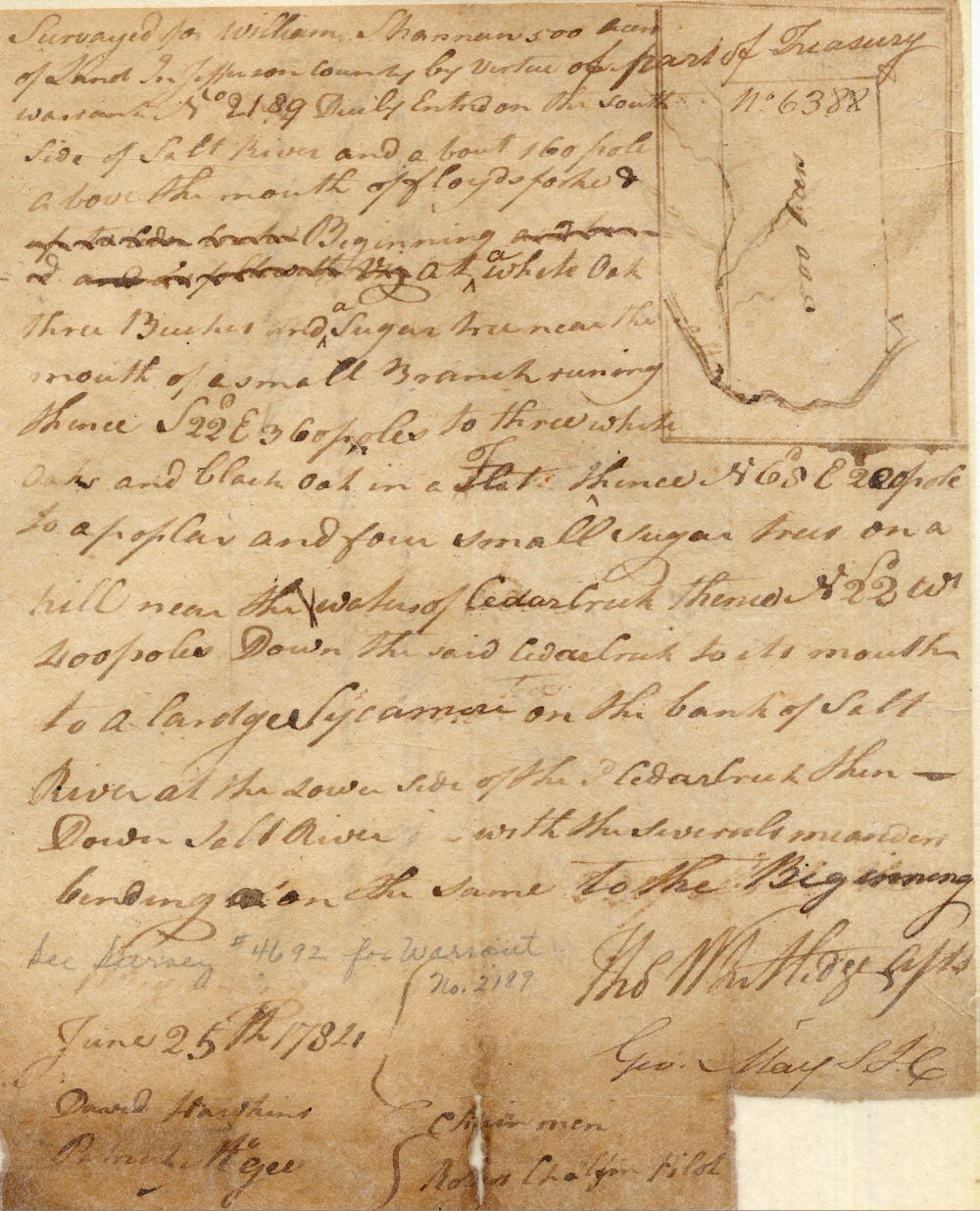
Surveyed for William Shannon 500 acres of land in Jefferson County by virtue of part of treasury warrant No. 2189 duly entered on the south side of Salt River and about 160 poles above the mouth of Floyd's Fork, beginning at a white oak, three beeches and a sugar tree near the mouth of a small branch, running thence S 22 E 360 poles to three white oaks and black oak in a flat, thence N 65 E 220 poles to a poplar and four small sugar trees on a hill near the waters of Cedar Creek, thence N 22 W 400 poles down the said Cedar Creek to its mouth to a large sycamore on the bank of Salt River at the lower side of the said Cedar Creek, then down Salt River with the several meanders binding on the same to the beginning. June 25th 1784. Thomas Whitledge, Assistant Surveyor. David Hawkins & Patrick McGee, chain men. Robert Chalfin(?), pilot.
Deed
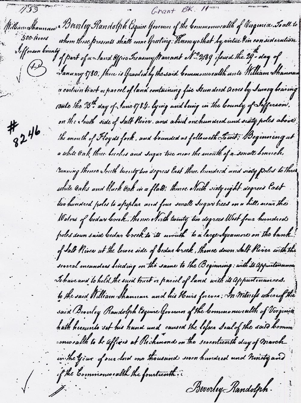
Virginia Grant Book 11
Beverly Randolph Esquire, Governor of the Commonwealth of Virginia to all to whom these presents shall come, greeting. Know ye that by virtue and in consideration of part of a land office treasury warrant No. 2189 issued the 29th day of January 1780, there is granted by the said Commonwealth unto William Shannon a certain tract or parcel of land containing five hundred acres by survey bearing date the 25th day of June 1784, lying and being in the County of Jefferson on the south side of Salt River and about one hundred and sixty poles above the mouth of Floyd's Fork, and bounded as followeth, to wit. Beginning at a white oak, three beeches and sugar tree near the mouth of a small branch, running thence South twenty two degrees East three hundred and sixty poles to three white oaks and black oak in a flat, thence North sixty eight degrees East two hundred poles to a poplar and four small sugar trees on a hill near the waters of Cedar Creek, thence North twenty two degrees West four hundred poles down said Cedar Creek to its mouth to a large sycamore on the bank of Salt River at the lower side of Cedar Creek, thence down Salt River with the several meanders binding on the same to the Beginning, with its appurtenances to have and to hold the said tract or parcel of land with its appurtenances to the said William Shannon and his heirs forever. In witness whereof the said Beverly Randolph Esquire, Governor of the Commonwealth of Virginia, hath hereunto set his hand and caused the lesser seal of the said Commonwealth to be affixed at Richmond on the seventeenth day of March in the year of our Lord one thousand seven hundred and ninety and of the Commonwealth the fourteenth. (signed) Beverly Randolph
If you, the reader, have an interest in any particular part of our county history, and wish to contribute to this effort, use the form on our Contact Us page to send us your comments about this, or any Bullitt County History page. We welcome your comments and suggestions. If you feel that we have misspoken at any point, please feel free to point this out to us.
The Bullitt County History Museum, a service of the Bullitt County Genealogical Society, is located in the county courthouse at 300 South Buckman Street (Highway 61) in Shepherdsville, Kentucky. The museum, along with its research room, is open 10 a.m. to 4 p.m. Monday through Friday. Saturday appointments are available by calling 502-921-0161 during our regular weekday hours. Admission is free. The museum, as part of the Bullitt County Genealogical Society, is a 501(c)3 tax exempt organization and is classified as a 509(a)2 public charity. Contributions and bequests are deductible under section 2055, 2106, or 2522 of the Internal Revenue Code. Page last modified: 12 Sep 2024 . Page URL: bullittcountyhistory.org/bchistory/william-shannon.html