
In 1785, Richard Johnson obtained both a 400 acre settlement tract and a 1000 acre preemption tract as described below. According to the records, he obtained this as an assignee of Thomas Johnson who in turn was an assignee of James McCollock. As this land appears to surround McCullough Run, a stream that flows into Salt River, it seems likely that the stream was named for Mr. McCollock, with the name being corrupted into McCullough.
James McCollock (McCullough) was in Kentucky in 1775, where he is said to have spent enough time to plant a crop of corn in the vicinity of what is now called McCullough Run in Bullitt County. This was verified by the Virginia Land Commissioners in January 1780 when they met at Harrodsburg to consider claims.
However, it was Thomas Johnson (Johnston) to whom they awarded settlement and preemption rights, as it appears that McCollock had assigned those rights to Johnson. Below is an image of the certification document, followed by its transcription.
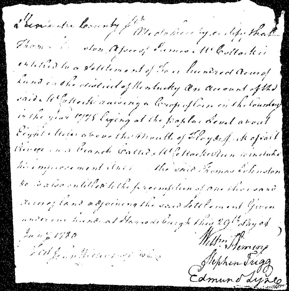
"Kentucky County. We hereby certify that Thomas Johnson, assignee of James McCollock, is entitled to a settlement of four hundred acres of land in the district of Kentucky on account of the said McCollock raising a crop of corn in the county in the year 1775 lying at the poplar level about eight miles above the mouth of Floyds fork of Salt River on a branch called McCollock's Run to include his improvements and the said Thomas Johnston is also entitled to the preemption of one thousand acres of land adjoining the said settlement given under our hand at Harrodsburgh this 29th day of Jany 1780. (by) William Fleming, Stephen Trigg, Edmond Lyne"
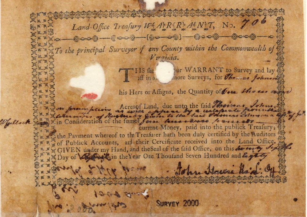
Then, on 26 Apr 1780, Thomas Johnson obtained a Virginia Land Office Treasury Warrant for one thousand acres of preemption land based on the commissioners' certification. He paid four hundred pounds, current money, for that warrant, which is shown below.
In May 1784, Thomas Johnson had both settlement and preemption surveyed, as shown below.
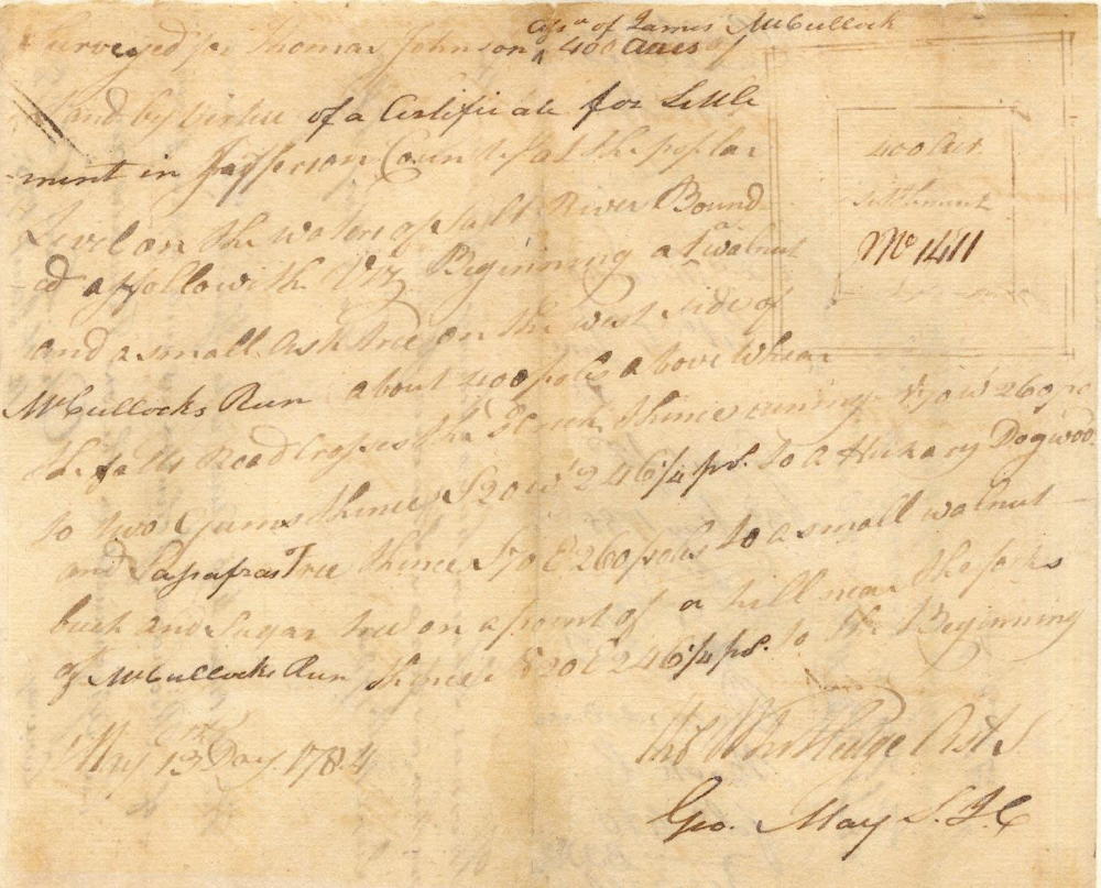
"Surveyed for Thomas Johnson, assignee of James McCullock, 400 acres of land by virtue of a certificate for settlement in Jefferson County at the poplar level on the waters of Salt River, bound as followeth viz. Beginning at a walnut and small ash tree on the west side of McCullocks Run, about 400 poles above where the falls road crosses the creek, thence running N 70 W 260 poles to two gums, thence S 20 W 246 1/4 poles to a hickory, dogwood & sassafras tree, thence S 70 E 260 poles to a small walnut, beech, & sugartree on a front [point?] of a hill near the forks of McCullocks Run, thence N 20 E 246 1/4 poles to the Beginning.
May 13, 1784
Thos Whitledge & Geo May"
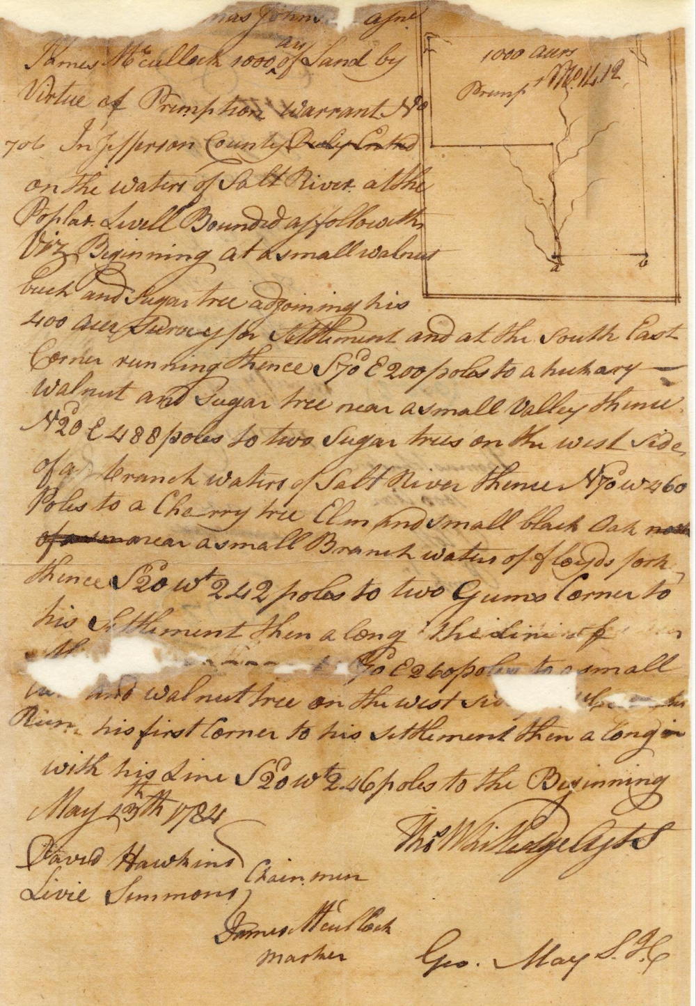
"Surveyed for Thomas Johnson, assignee of James McCullock, 1000 acres of land by virtue of preemption warrant No. 706 in Jefferson County on the waters of Salt River at the Poplar Level bounded as followeth, viz Beginning at a small walnut, beech and sugar tree adjoining his 400 acre survey for settlement and at the south east corner, running thence S 70 E 200 poles to a hickory, walnut and sugar tree near a small valley, thence N 20 E 488 poles to two sugar trees on the west side of a branch waters of Salt River, thence N 70 W 460 poles to a cherry tree, elm and small black oak, thence S 20 W 242 poles to two gums corner to his settlement, then along the line of the same S 20 E 260 poles to a small ash and walnut tree on the west side of McCullocks Run, his first corner to his settlement, then along with his line S 20 W 246 poles to the Beginning.
May 13th 1784
Thos Whitledge, Geo May"
Then, in September 1784, Thomas Johnson assigned his right to the settlement and preemption land to Richard Johnson, as shown below (image and transcript).
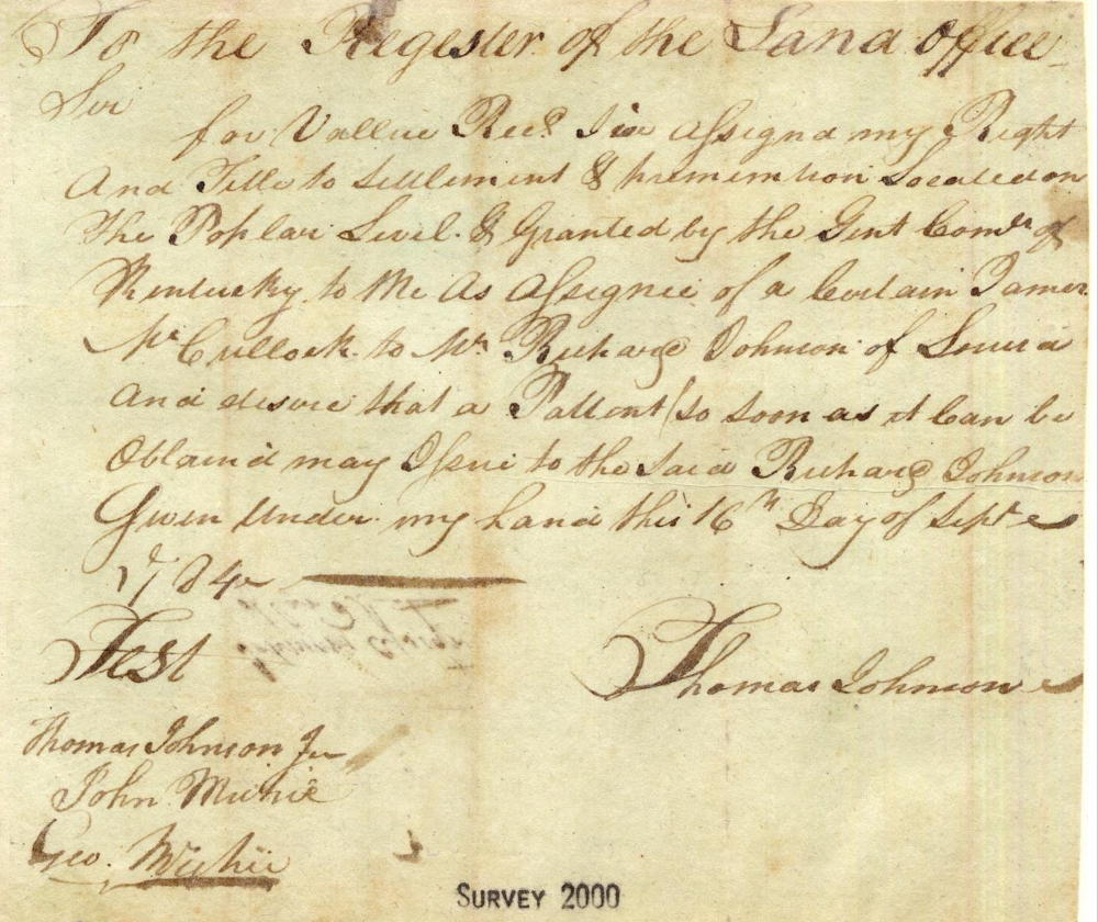
"To the Register of the Land Office.
Sir: For value recd I've assigned my right and title to settlement & preemption located on the poplar level, & granted by the Gent Comrs of Kentucky to me as assignee of a certain James McCullock to Mr. Richard Johnson of Louisa and desire that a patent so soon as it can be obtained may assine to the said Richard Johnson. Given under my hand this 16th day of Sept 1784. (signed) Thomas Johnson"
Richard Johnson obtained his deeds to the two properties on 23 May 1785, as shown below.
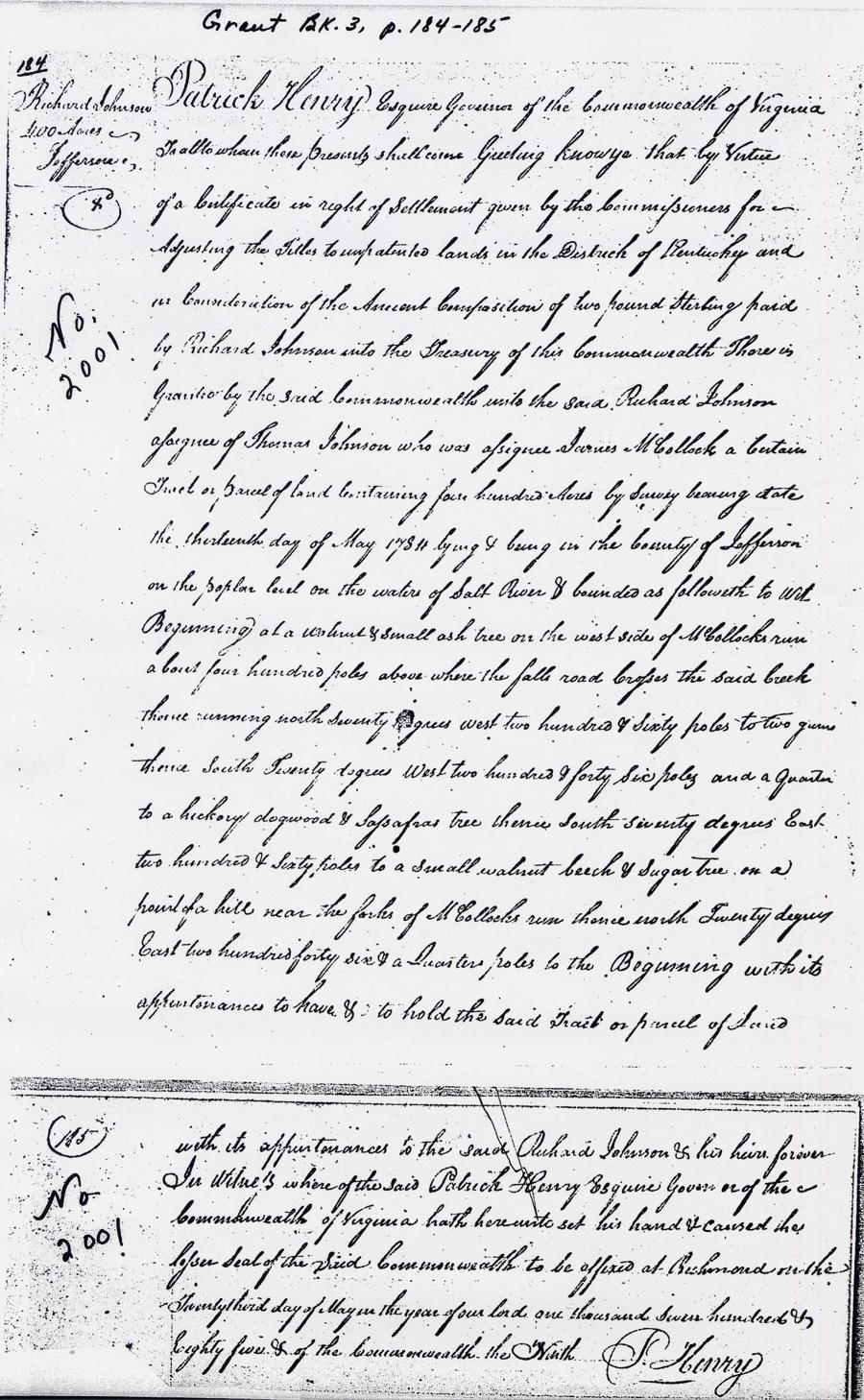
A transcript of the settlement tract deed follows, along with an image of the deed itself.
"Virginia Grant Book 3, pp. 184-185
Patrick Henry Esquire, Governor of the Commonwealth of Virginia, to all to whom these presents shall come, Greeting. Know ye that by virtue of a certificate in right of settlement given by the Commonwealth for adjusting the titles to unpatented lands in the District of Kentucky and in consideration of the amount composition of two pound sterling paid by Richard Johnson into the treasury of the Commonwealth, there is granted by the said Commonwealth unto the said Richard Johnson, assignee of Thomas Johnson who was assignee of James McCollock, a certain tract or parcel of land containing four hundred acres by survey bearing date the thirteenth day of May 1784, lying and being in the County of Jefferson on the poplar level on the waters of Salt River & bounded as followeth to wit: Beginning at a walnut & small ash tree on the west side of McCollock's run about four hundred poles above where the falls road crosses the said creek, thence running north seventy degrees west two hundred & sixty poles to two gums, thence south twenty degrees west two hundred & forty six poles and a quarter to a hickory, dogwood & sassafras tree, thence south seventy degrees east two hundred & sixty poles to a small walnut, beech & sugartree on a front of a hill near the forks of McCollocks run, thense north twenty degrees east two hundred forty six & a quarter poles to the Beginning with its appurtenances, to have & to hold the said tract or parcel of land with its appurtenances to the said Richard Johnson & his heirs forever. In witness whereof the said Patrick Henry Esquire, Governor of the Commonwealth of Virginia hath hereunto set his hand & caused the lesser seal of the said Commonwealth to be affixed at Richmond on the twenty third day of May in the year of our Lord one thousand seven hundred & eighty five, & of the Commonwealth the Ninth.
(signed) P. Henry"
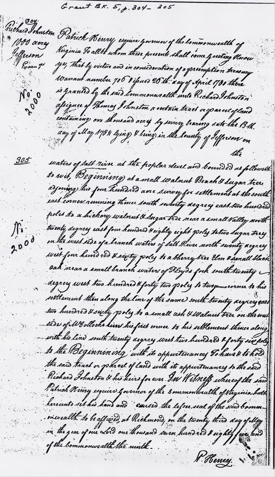
A transcript of the preemption tract deed follows, along with an image of the deed itself.
"Virginia Grant Book 5, pp. 304-305
Patrick Henry Esquire, Governor of the Commonwealth of Virginia, to all to whom these presents shall come, Greeting. Know ye that by virtue and in consideration of a preemption treasury warrant number 706 issued 26th day of April 1780, there is granted by the said Commonwealth unto Richard Johnston, assignee of Thomas Johnston a certain tract or parcel of land containing one thousand acres by survey bearing date the 13th day of May 1784 & lying & being in the County of Jefferson on the waters of Salt River at the poplar level and bounded as followeth to wit: Beginning at a small walnut, beech & sugar tree adjoining his four hundred acre survey for settlement at the southeast corner, running thence south seventy degrees east two hundred poles to a hickory, walnut & sugar tree near a small valley, north twenty degrees east four hundred and eighty eight poles to two sugar trees on the west side of a branch waters of Salt River, north seventy degrees west four hundred & sixty poles to a cherry tree, elm, & small black oak near a small branch waters of Floyds fork, south twenty degrees west two hundred & forty two poles to two gums corner to his settlement, then along the line of the same south twenty degrees east two hundred & sixty poles to a small ash & walnut tree on the west side of McCollocks run, his first corner to his settlement, thence along with his line south twenty degrees west two hundred & forty six poles to the Beginning with its appurtenances to have and to hold the said tract or parcel of land with its appurtenances to the said Richard Johnston & his heirs forever. In witness whereof the said Patrick Henry Esquire, Governor of the Commonwealth of Virginia hath hereunto set his hand and caused the lesser seal of the said Commonwealth to be affixed at Richmond on the twenty third day of May in the year of our Lord one thousand seven hundred & eighty five and of the Commonwealth the ninth.
(signed) P. Henry"
Richard Johnson (or Johnston) also claimed a 2,000 acre tract that bordered on the earlier tracts. Here is the survey followed by its transcription.
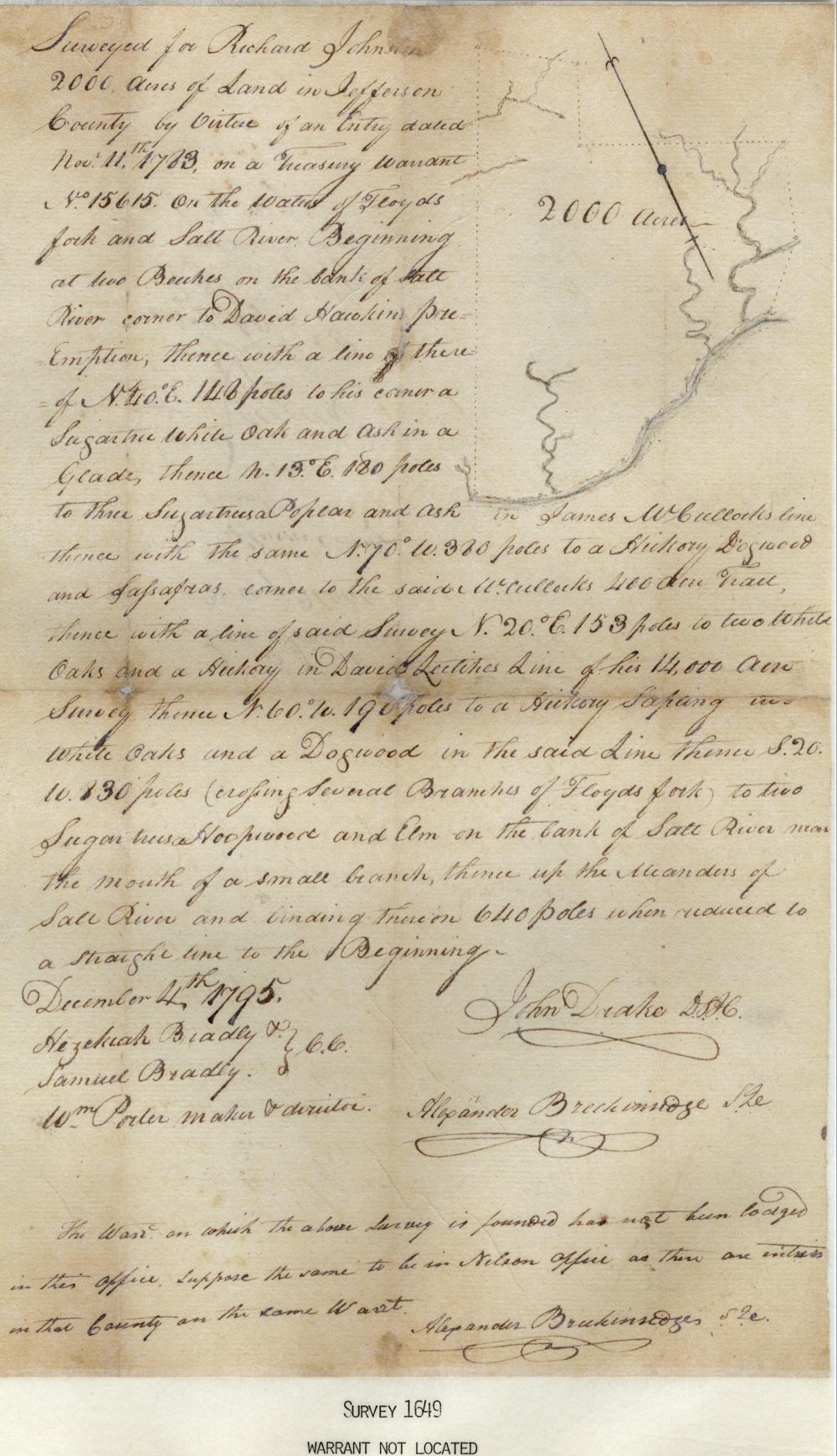
"Surveyed for Richard Johnston 2000 acres of land in Jefferson County by virtue of an entry dated Nov 11th 1783, on a treasury warrant No. 15615 on the waters of Floyd's fork and Salt River. Beginning at two Beeches on the bank of Salt River, corner to David Hawkins' preemption, thence with a line there of N 40° E 148 poles to his corner a Sugartree, white oak and ash in a glade, thence N 13° E 180 poles to three sugartrees, poplar and ash in James McCullock's line, thence with the same N 70° W 380 poles to a Hickory, Dogwood and Sassafras corner to the said McCullock's 400 acre tract, thence with a line of said Survey N 20° E 153 poles to two white oaks and a Hickory in David Leitches line of his 14,000 acre Survey, thence N 60° W 190 poles to a hickory sapling and white oaks and a Dogwood in the same line, thence S 20° W 830 poles (crossing several branches of Floyds fork) to two Sugartrees, Hoopwood and Elm on the bank of Salt River near the mouth of a small branch, thence up the meanders of Salt River and binding thereon 640 poles when reduced to a straight line to the Beginning.
December 4th 1795
John Drake
Alexander Breckinridge"
As you can see, the entry was made in 1783, but the survey was not completed until 1795. There is also some question about the warrant it was based on. However, he was given a deed to it, as shown below.
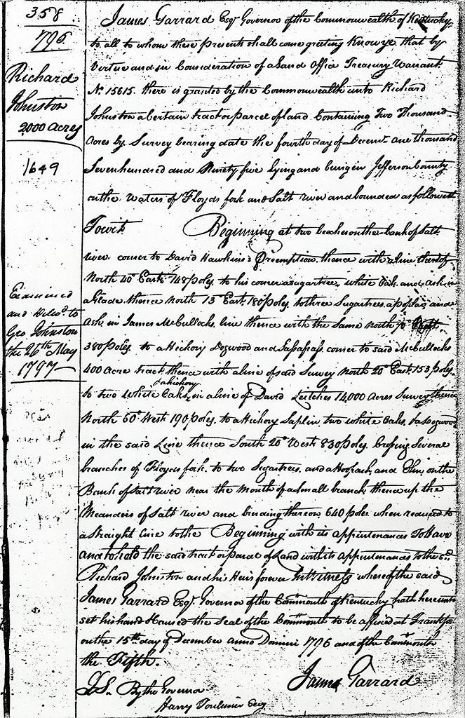
"James Garrard Esq, Governor of the Commonwealth of Kentucky, to all to whom these presents shall come, greeting. Know ye that by virtue and in consideration of a Land Office Treasury Warrant No. 15615, there is granted by the Commonwealth unto Richard Johnston a certain tract or parcel of land containing two thousand acres by survey bearing date the fourth day of December, one thousand seven hundred and ninety five, lying and being in Jefferson County on the waters of Floyd's fork and Salt River and bounded as followeth, towit: Beginning at two Beeches on the bank of Salt River, corner to David Hawkins' preemption, thence with a line thereof North 40˚ East 148 poles to his corner a Sugartree, white oak and ash in a glade, thence North 13˚ East 180 poles to three Sugartrees, a Poplar and ash in James McCullock's line, thence with the same North 70˚ West 380 poles to a Hickory, Dogwood and Sassafras, corner to the said McCullock's 400 acre tract, thence with a line of said survey North 20˚ East 153 poles to two white oaks and a hickory in a line of David Leitches' 14,000 acre Survey, thence North 60˚ West 190 poles to a hickory saplin, two white oaks and a dogwood in the said line, thence South 20˚ West 830 poles (crossing several branches of Floyds fork) to two Sugartrees, and a hoopash, and elm on the bank of Salt River near the mouth of a small branch, thence up the meanders of Salt River and binding thereon 640 poles when reduced to a straight line to the beginning, with its appurtenances, to have to and to hold the said tract or parcel of land with its appurtenances to the said Richard Johnston and his heirs forever. In witness whereof the said James Garrard Esq. Governor of the Commonwealth of Kentucky, hath hereunto set his hand & caused the seal of the Commonwealth to be affixed at Frankfort on the 15th day of December anno dominio 1796 and of the Commonwealth the fifth.
(signed) James Garrard"
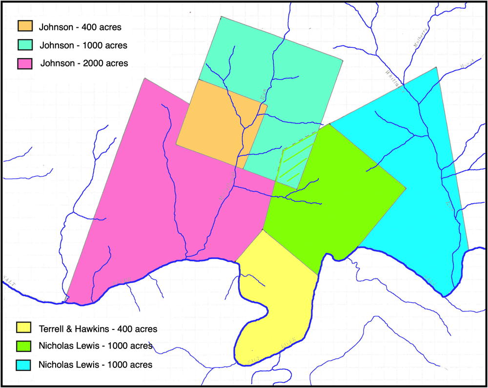
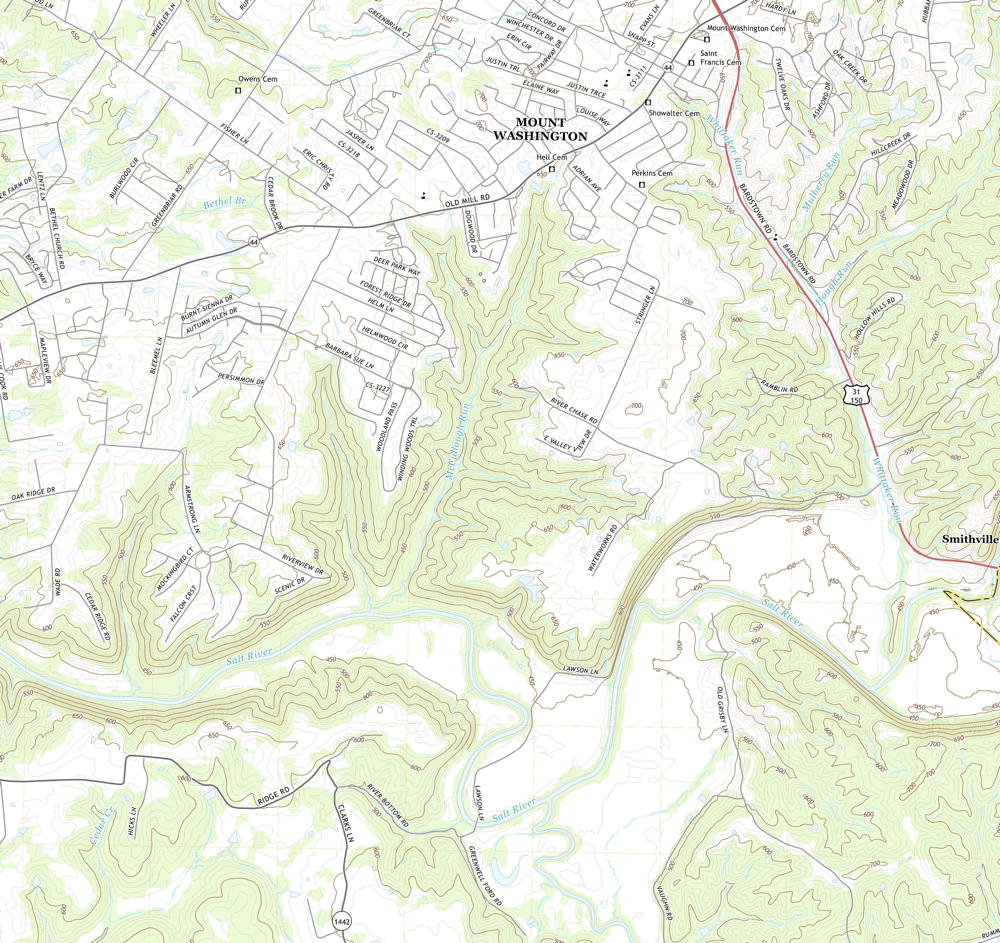
We have attempted to determine the location of these tracts and the map below shows a rough approximation of where they might have been located. The size and shape of the tracts are reasonably accurate; their actual location is our best guess based on the information in the surveys and deeds. This map also shows the approximate locations of adjoining tracts to the east. The second map below is part of topographic maps drawn in 2019 that show the same region This will help you locate these tracts more closely.
Richard Johnson began selling parts of his land as early as 17 Nov 1788. For more information, follow this link.
If you, the reader, have an interest in any particular part of our county history, and wish to contribute to this effort, use the form on our Contact Us page to send us your comments about this, or any Bullitt County History page. We welcome your comments and suggestions. If you feel that we have misspoken at any point, please feel free to point this out to us.
The Bullitt County History Museum, a service of the Bullitt County Genealogical Society, is located in the county courthouse at 300 South Buckman Street (Highway 61) in Shepherdsville, Kentucky. The museum, along with its research room, is open 10 a.m. to 4 p.m. Monday through Friday. Saturday appointments are available by calling 502-921-0161 during our regular weekday hours. Admission is free. The museum, as part of the Bullitt County Genealogical Society, is a 501(c)3 tax exempt organization and is classified as a 509(a)2 public charity. Contributions and bequests are deductible under section 2055, 2106, or 2522 of the Internal Revenue Code. Page last modified: 12 Sep 2024 . Page URL: bullittcountyhistory.org/bchistory/johnson-tract.html