
I first wrote about Paroquet Springs in 2012 in a brief article for The Courier-Journal. This was followed up in 2015 with a two-part article on John D. Colmesnil and his relationship to the Springs. You may learn even more about Mr. Colmesnil's life by following this link.
Then, in January and February 2021, I wrote another two-part article for The Pioneer News that traces the history of the land that became Paroquet Springs. Because it includes virtually all of the original 2012 article, I have modified and expanded it, and placed it here in place of the original article.
By 1781, the Bullitt Lick saltworks had been in operation for more than a year, and folks were living at places along Salt River like Brashear's Station, Dowdall's Station, and Mud Garrison. However much of the land along the north side of the river had yet to be surveyed for claims. Then in March, two surveyors working independently surveyed four different tracts stretching from Colonel Christian's Bullitt Lick tract upstream to the mouth of Floyd's Fork.
This area was then still part of Jefferson County. Benjamin Stansbury and James Hord had been deputized by Jefferson County Surveyor George May, and they both set out to survey the area. Stansbury was hired by Nicholas Brashear to survey his 400 acre patent which would include Brashear's Station near the mouth of Floyd's Fork. Stansbury completed this task on March 12th.
Then three days later, on March 15th, James Hord set to work surveying two tracts, the first for Jacob Myers, the second of Thomas McGee. He began at the river next to the line that Stansbury had marked for Brashear, and proceeded to lay out Myers' 400 acre patent to the west of the Brashear tract. This tract included the location of Dowdall's Station.
Finished with Myers' tract, Hord continued on westward, laying out 450 acres for Thomas McGee, the tract we will be most interested in today.
A week later, on March 22nd, Stansbury was busy again. This time he was working for Adam Shepherd, and laying out his father, Peter Shepherd's 900 acre tract just to the west of McGee's land. It would be on 50 acres of land on the river in this tract that Shepherdsville would begin. Stansbury would also lay out 600 more acres for Peter Shepherd on the opposite side of Salt River from his 900 acre tract.
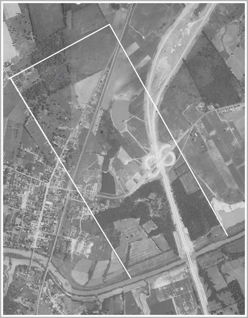
To help us understand better where Thomas McGee's 400 acres was, I've included here an aerial photo taken in 1956 that has the approximate location of his land outlined. As you can see, his land lay upstream from downtown Shepherdsville, and included the interchange for the then-new Kentucky Turnpike. The western border extended up Blue Lick Road, and the upper-right corner included the present-day site of the Shepherdsville post office.
As James Hord worked his way through the forest to lay out Thomas McGee's tract, one can only imagine how amazed he would have been had he known what would take place there in the ensuing years.
At that time some of the old growth forest had begun to give way to the axe as trees were felled for building, or more likely for fuel at the salt works; but it was still mainly a forested area including a large hickory on the river bank that marked the boundary between Myers' and McGee's land.

Just downstream from that hickory a small stream emptied into the river. It wasn't much of a stream, but it did extend northward across most of McGee's land. I'm sure it went by several names, including McGee's Branch or Creek, but the name that stuck to it came from the pretty birds that seemed to enjoy being there.
Known as Carolina parakeets, these small parrots, with bright yellow heads, reddish-orange faces and pale beaks, flocked together in the deep forests. Soon, the creek became known as the Parakeet branch or creek. Unfortunately for the birds, the destruction of old-growth forests across the Eastern United States, combined with a desire for the colorful feathers for fashionable hats would drive these birds to extinction.
Thomas McGee died in 1783, leaving his extensive properties to the various members of his large family. It appears that his brother John inherited the 400 acre tract. John lived in Nelson County, and likely leased the Bullitt County property to various individuals for logging or farming.
Saltmaking continued to be an important industry in this area, and it was well known that the little stream on the McGee property was one of the streams that dissolved various minerals and salts as it traveled to the river. However, the level of salt in the water was insufficient to allow it to compete with the larger licks in the area.
All that changed around 1802 when the larger saltworks attempted to drive up the price of salt by ceasing production and storing what they had. The demand for salt encouraged James Burks to lease the lick on the Parakeet stream from McGee, and, together with John Dunn who provided the kettles, he set to work boiling down the water to produce salt. The need for firewood under the kettles meant that more and more of the tall trees felt the bite of the axe.
Saltmaking and the subsequent logging continued for a couple of years; but then the larger works reopened, and it was soon unprofitable to continue working the Parakeet Lick, as it was then known.
John McGee died in 1811, and his properties were distributed among his offspring. Soon the Parakeet Lick tract was being divided up. John McDowell purchased the property that included the lick, and made his home on the northern end. When his daughter married Reuben Morgan, he settled them on the south end where the lick was located.
Mineral waters, like that found at the Parakeet spring, had been promoted for its supposed medicinal properties for a long time, and Morgan, a Shepherdsville attorney, was the first to see the commercial potential of the mineral spring water.
In the mid 1820s, he interested some locals in its possibilities and a road from town was opened to a well dug beside the stream. They built a shelter over the well, and advertised the healing properties of the water. However, it was mainly used by people living nearby, and Morgan gave up on it and moved away.
In 1836, John McDowell sold the tract to Humphrey Simmons who kept part of it and sold the rest, including the well site, to James Guthrie who was acting as a trustee for Mrs. Sarah Colmesnil, wife of John D. Colmesnil who actually put up the money to purchase the land.
By this time most of the old growth forest was gone, having fallen before the demands of the saltworks. However, new growth was returning shade to the land, filling in the gaps between the scattered remaining old trees.
Colmesnil, whose business took him frequently to New Orleans, purchased the place as a retreat for his wife while he was gone. A shrewd businessman, he also saw the potential for a mineral springs spa on the site, and it was first opened in 1838 to a small number of persons, principally invalids.
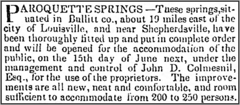
By the summer of 1839 he had built enough accommodations for two hundred or more people, and at the end of May he placed the advertisement you see here from The Louisville Daily Journal.
We learn how he did that summer from an article written in the Louisville paper the following June whose author wrote that they "found their boarding house, cottages, etc., crowded to overflowing. The greatest number of visitors at Paroquet, at one time, is said to have been about two hundred and fifty; and none, we are persuaded, came away otherwise than thoroughly impressed with the conviction that this was destined, at no distant day, to become the most celebrated watering place in the western country."
The reporter continued, "Large additions have been made to the buildings during the past winter and spring, which will enable the proprietors to accommodate this season between 300 and 400 persons. In natural beauty and loveliness, Paroquet has no rival among the different watering places we have visited; and improvements are daily going on under judicious management, which will render the spot one of the most lovely and attractive summer retreats to be found in the Union.
"The grounds belonging to the establishment occupy about two hundred acres, along the west bank of Salt River. You approach them from the west side, through a young grove of hickory, cedar, oak, etc. The middle of the grounds is a sort of table land, quite level, sufficiently elevated to be always dry, thickly carpeted with grass, and shaded with a beautiful growth of young hickory, cedar, oak, sugar-maple, locust, buckeye, etc., all of nature's own planting and set in her own graceful irregularity. Here and there occurs a small sunny glade, in the middle of which a venerable oak rears its head and spreads abroad its giant branches - a solitary sentinel of the spot around which its companions of a former age have long since mouldered into dust. From this level area, the land slopes away gracefully on the east and north-east to the river, along the banks of which, and also in the rear of the principal row of cottages, still stands a heavy growth of timber, affording a deep and sombre shade, rendered often more dense by the thick foliage of the wild grape-vine, whose giant folds have encircled the oak and elm. Along the south side of this area a small stream has cut a channel through the lime rock, resembling a narrow canal; and down to this small stream several little green valleys wind from the table land above."
Colmesnil had to have been happy with this reporter whose article did such a remarkable job of picturing the spa and its grounds.
The writer continued, "The grounds are tastefully enclosed, and walks of gravel or bark wind through them in different directions underneath the trees. A line of neat cottages is built upon the north side of the level area; and across this area, and fronting them, at a distance of a hundred and fifty or sixty yards, stand the boardingehouse, dining-hail, bath houses, etc. Seventy-five yards west of the boarding-house the proprietors have just erected a ball-room, 108 feet by 32. Salt River affords excellent fishing, and the woods for many miles around furnish plenty of game to the sportsman. For those fond of rowing or sailing there are convenient boats upon the river; so that persons can go with oar or sail 'up Salt River,' or down, or - across it. And for the information of those, who, having never tried it, are haunted with an indefinable dread of being 'rowed up Salt River,' we can assure them, from our own experience, there is, after all, nothing fearful in the operation: Nay, when as last summer, we were favored with the company of beautiful and charming ladies we found, it a most delightful kind of navigation. The banks of the river are highly beautiful, and the stately trees that skirt the water's edge, put forth their long arms to caress the stream as it passes quietly and gently by."
His reference with being "rowed up Salt River" alluded to what was by then a common phrase, often used to refer to what happened to losing politicians. A few years earlier The Louisville Advertiser had printed this explanation.
"Salt River is a small stream in this State, which empties into the Ohio River about twenty miles below this city. In the neighborhood of Shepherdsville, where the phrase of 'rowing up Salt river' originated, it is filled with rapids, snags, rocks, and sandbars. Of course, the navigation is extremely difficult, and rowing up Salt River is a matter not to be sneezed at. The labor attending it was so well known to those residing in the vicinity, that it became common among them, whenever any one spoke of some very arduous undertaking, to tell him that he would find it harder than trying to row up Salt River. When some bully had received a sound whipping, it also became common to say that he had been 'rowed up Salt River,' and the same remark was likewise applied to a defeated political party. If the defeat was overwhelming, they were said to be 'rowed very far up Salt River.'"
The reporter concluded his article, saying, "Mr. Colmesneil has associated with himself in the management of the establishment Mr. Noble, late of Lexington, whose polite and gentlemanly attentions to visitors will be well recollected by those who frequented Paroquet last season. Under the direction of two such gentlemen, the establishment, with all the advantages we have enumerated, must prosper."
The spa's reputation spread throughout the region, and the business prospered. In 1844, Colmesneil was advertising that daily stages would bring guests from the Galt House in Louisville, and that there was also a line from Mt. Washington that connected with the Louisville and Bardstown stage.
Gradually however, business faltered and, as Mr. Colmesneil was getting older, he decided to lease the spa to others beginning in 1848. At this point we would be remiss were we to fail to mention the Lone Grave.
Anyone with the slightest notion of our county's history has likely heard stories about the Lone Grave that sits inside the woods on the east side of the I-65 exit ramp, and I certainly have my choice of stories about the mysterious lady who is said to be buried there. However, the one that rings the truest to my ears is the earliest that I have located in any newspaper thus far; one that I found in an Ohio paper dated October 1, 1874.
It begins, "Just beyond a ravine to the right of the buildings in a secluded spot, under a great oak tree, is the grave of a woman whose name and the story of whose life has not been inscribed on a tombstone. It is a simple mound surrounded by a neat and substantial iron railing, having on it no inscription or mark indicating who tenants the grave."
The article tells of a time, perhaps 25 years earlier (1849) when the daughter of a rich family visits the spa and falls in love with a gentleman whose financial and social standing does not satisfy the girl's father. She is whisked off to Europe, remaining there for a few years, before returning to New Orleans where her father finds her a "suitable" husband.
It concludes, "The marriage was only a short time previous to her death. Upon her death bed she asked to be buried upon this spot, and her husband promised that she should rest at Paroquet in the place indicated by her. He complied with her wishes, but made it a stoneless and nameless grave. He raised no monument, nor planted any flower over it. It lies there barren and alone, save that the wild flowers come in the spring, and summer visitors at Paroquet strew myrtle and cut roses upon it."
In other versions of this story the young lady is betrayed by her supposed beau who marries another, or he is killed in the war with Mexico, or he simply disappears without a trace; but, in every case, her unrequited love leads her to her grave at Paroquet Springs.
Picking our Paroquet Springs story up again, things began to look up with the building of the railroad from Louisville to Shepherdsville, completed in October 1855. The following April, Colmesneil once again advertised the spa for lease, and a writer in the same issue wrote, "Louisville needs just such a place of resort in the summer months as the Paroquet Springs afford, and all the city will flock to them when opened again to visitors, now that the railroad has brought them within half an hour's ride from the city."
In December 1857, a group of men received approval from the General Assembly to incorporate the Paroquet Springs Company with the main purpose of purchasing the Paroquet Springs spa and lands. However, they don't appear to have reached a purchase agreement at that time.
Colmesneil was once again offering it for lease in May 1859. All this came to an end in 1861 with the beginning of the Civil War. Union forces sent to protect the railroad bridge at Shepherdsville were quartered at Paroquet Springs, occupying the cottages once reserved for vacationing families.
It was the most accessible place for a military camp near the railroad bridge, and became Camp Washington for much of the duration of the war. It is unclear to what extent the facilities were damaged during that time, but many of its trees were cut for firewood. Then in the late 1860s there was again interest in reopening the spa.
In March 1869, James Guthrie died, requiring Colmesnil to find a new "next friend" to represent his wife's affairs. He turned to Richard H. Field, a local attorney and politician who assumed the role in April 1871. That same month, Field sold the spa and property to a group of Louisville businessmen, doing business as the Paroquet Springs Company, and plans were immediately made to reopen the spa that summer.
A considerable amount of money was borrowed and spent preparing the facilities for an inaugural opening ball to be held in July. Delayed by a week, it finally occurred on July 27th, and by all accounts was a grand success, attracting visitors from as far away as New Orleans. One of them wrote a sparkling article for a New Orleans newspaper in which he described the event in glowing terms, perhaps with a little encouragement by the management.
He described the grounds this way: "The hotel park contains one hundred acres of ground and comprises nearly every variety of trees known, forming a cooling shade and most delightful lawn for children in the gambols, and for enterprising and romantic lovers to hold sweet converse and to enjoy the music from the carols of innumerable songsters. Salt River runs within fifty yards of the hotel, and every afternoon crowds of gaily dressed ladies may be seen floating over its clear bosom in the luxurious gondolas so generously furnished, free, for the use of the guests."
Turning to the hotel itself, he wrote, "The hotel is a wonder of architectural beauty, and a paragon of comfort. It is nearly four hundred feet long and sixty-five feet wide, with a continuous gallery around the entire building, twenty-five hundred feet long and fifteen feet wide (so that plenty of exercise can be had indoors in rainy weather) and eight feet halls between the rooms. The rooms are sixteen feet square with lofty ceilings and thorough ventilation, many of them connected for family use. The ballroom and dining room are each eighty-six feet long by forty feet wide, and the parlors are perfectly elegant. The cuisine is the very best. No expense has been spared to secure the most competent artists in this department, and the table literally groans with its generous load of palatable food, the choicest viands and luscious fruits."
He spent considerable space naming many of the ladies who attended the ball, and describing their gowns. Among the many daughters, nieces, and wives of prominent Kentuckians, there were a handful of local ladies including Miss Katie Hamilton, described as "an exquisite blonde dressed with white satin train, overskirt of blue crepe, looped with pink morning glories and black velvet band fastened with diamond pin." Kate was a daughter of Henry Crist Hamilton and Rachel Eleanor (Swearingen) Hamilton of Mt. Washington.
Despite the social success of the inaugural ball, the proprietors soon found that their expenses had exceeded their income that summer, and in November they were sued by their creditors in Louisville Chancery Court, and forced to place the spa and its land in mortgage to cover their debts. Any hope of recovery by the company was dashed when the U.S. District Court declared them bankrupt in December.
The following March, the spa was advertised for sale, and everything was sold to another group of Louisville businessmen who saw the Springs as an opportunity. Again investments were made to present the spa in the best light, and another grand ball was advertised for the end of June.
A writer for a Louisville newspaper described it this way: "The ball was a grand success. The proprietors spared no pains to make it superior in every respect to the first, and we are not sure but that abundant triumph crowned their efforts. The ballroom was crowded from the first note of the music until its last echoes had died away, when unwelcome morn crept through the windows with as happy a company as we may not often see. It was a beautiful sight, such as only Kentucky's beauty and grace can afford - for the best and the fairest of Kentucky's women lent their presence to the occasion."
He continued, "Yesterday the grounds were alive with happy faces - the majority of those who went down for the ball having remained over for Saturday and Sunday. The beautiful river was crowded with boats; the woods and avenues filled with gay promenaders. It was altogether a brilliant ball and a charming day, and Paroquet Springs will hereafter be connected with many a pleasant remembrance for each one of the hundreds who collected there Friday and yesterday."
I've also read of a "fine racetrack" that was built on the grounds that was in use until about 1879.
Once again, however, it seems that their investment in the spa had not produced the profit they sought. By 1874, the spa had been leased to a Mr. Van Seggern who advertised it more for its medicinal waters than its social climate.
By May 1879, the property was owned by J. W. Calvert, T. B. Curry, S. P. Meyer, and the estate of John Ferry, and was leased by J. W. Hall when the large hotel burned to the ground. Hall and his family were living in the hotel at the time, and barely escaped with their lives.
In February 1881, Thornton B. Curry appears to have gained control of the property by agreeing to pay the other owners' obligations.
By 1882, the property was being offered for sale, described as having "eight buildings with 70 rooms (accommodate 150 guests), billiard and dancing hall, club-house, cottages, beautiful groves, great medicinal spring, finest picnic grounds around Louisville."
Then in 1885, its creditors forced the sale of the property to recover what they could of its debt of nearly $18,000. They didn't get much, the property selling for less than $4,000 to George W. Simmons. By that time the spa had been closed for several seasons, although the grounds had been used by the Methodists as a camp-meeting ground, and was frequently the site of picnics and outings such as the one that took place in the summer of 1887 when a a group of mostly young adults from Louisville decided to have a two-week holiday in the country, as described on another page.
In 1902, newspaper reports suggested that a New York syndicate might be interested in leasing the property and turning it back into a resort; but nothing came of it.
Periodically, someone would remember the days gone by, and a newspaper article would appear, such as the one in 1909 written for The Courier-Journal by J. R. Zimmerman in which he described the spa's glory days, and later one by Howard Hardaway in 1940 that focused on the Lone Grave.
In Zimmerman's article, he wrote that "for years the Paroquet Fishing Club of Louisville had a camp there, and many of Louisville's most prominent men came out to recreate."
But for many years Thomas McGee's original patent of 450 acres that straddled the Shepherdsville - Mt. Washington road was mostly just farmland, woods, and, in wet weather, swamp land.
Then in the early 1950s things began to change with the construction of the Kentucky Turnpike. Opened in 1956, its intersection ramps with Highway 44 all lay on parts of the original McGee tract, with the highway crossing Salt River just upstream from the mouth of Parakeet Creek.
By this time the McGee tract had been divided into multiple pieces, owned by different folks. The part north of Highway 44 and east of Buckman Street contained a number of small fishing lakes along the creek's path; and much of the part south of the highway was either wooded or in cultivation.
In the summer of 1978, Bill Hardy, then executive vice-president of the Peoples Bank of Shepherdsville, was interviewed about the town's growth, and said that the area just west of the interchange, which he remembered as a swamp, was being developed into Paroquet Springs, a commercial park that would soon have a large truck stop, a gas station, and a half-dozen restaurants.
Earlier in that decade, the Paroquet Springs Development Company had been incorporated by Kenny Stout and Danny Rayhill, along with directors Robbie Popplewell, Doris Rayhill, and George Joseph.
They bought approximately 100 acres from the descendants of George Simmons that once included the spa with a vision to create a commercial park. It began in 1976 with a Burger Queen restaurant where Taco Bell sits today. Other restaurants followed along the new Paroquet Springs Drive. This was followed by a Trucker's World facility just north of the river.
By 1980 the spa site had disappeared beneath fill brought in to build Trucker's World. Gone forever was the mineral spring well that had attracted so many visitors a century before.
Things were going quite well for the development until 1993 when Trucker's World abruptly closed when its parent company went bankrupt. Two years later it was sold at auction to James Rice, and by 1998 it was well on its way to becoming Paroquet Springs Convention Center.
Within the center you will find the beautiful model of the old Paroquet Springs hotel, pictured here, which was made by Lloyd Mattingly of Lebanon Junction, one of many models of older times made by him.

Then in 2002, another group purchased part of the former McGee tract north of Highway 44, and began developing a commercial development called Shepherd's Crossing, along with a new roadway that would become Adam Shepherd Parkway. This development was anchored by a new Kroger store.
The next year, Flynn Brothers Contracting Inc. purchased 263 acres of undeveloped Bullitt County property just west of Interstate 65 and north of Ky. 44 in Shepherdsville, and planned to build an industrial and business park there. This included much of the northern half of the original McGee tract.
Before any development was started on this property, the company built a bypass road connecting Highway 44 with Highway 61. We know it today as Conestoga Parkway, the roadway that opened up that whole area to development.
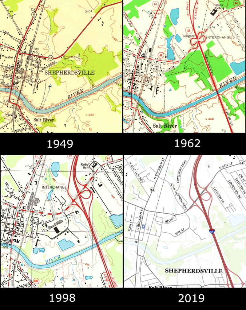
The collection of maps shown below will help you visualize the changes that took place in this area from 1949, before the interstate highway was constructed, through 2019.
March 15th, 2021, marks the 240th anniversary of the day James Hord first laid out Thomas McGee's 450 acre tract. I think we can safely say that neither man could have envisioned all that has occurred there since then. Kinda makes you wonder what the future holds for our communities, doesn't it. And now you know the rest of the story (for now).
The Bullitt County History Museum, a service of the Bullitt County Genealogical Society, is located in the county courthouse at 300 South Buckman Street (Highway 61) in Shepherdsville, Kentucky. The museum, along with its research room, is open 10 a.m. to 4 p.m. Monday through Friday. Saturday appointments are available by calling 502-921-0161 during our regular weekday hours. Admission is free. The museum, as part of the Bullitt County Genealogical Society, is a 501(c)3 tax exempt organization and is classified as a 509(a)2 public charity. Contributions and bequests are deductible under section 2055, 2106, or 2522 of the Internal Revenue Code. Page last modified: 12 Sep 2024 . Page URL: bullittcountyhistory.org/memories/psspa.html